
England's Historic Seascapes: Withernsea to Skegness
Museum of London Archaeology, 2010. https://doi.org/10.5284/1000104. How to cite using this DOI
Data copyright © Historic England unless otherwise stated
This work is licensed under the ADS Terms of Use and Access.


Primary contact
David
Bowsher
Director of Research
Museum of London Archaeology
Mortimer Wheeler House
46 Eagle Wharf Road
London
N1 7ED
UK
Tel: 020 7410 2285
Resource identifiers
- ADS Collection: 935
- ALSF Project Number: 4730
- DOI:https://doi.org/10.5284/1000104
- How to cite using this DOI
Outer Humber Estuary Character Area
Present Day Form
The Outer Humber Estuary character area is situated in the north-western extent of the study area and comprises the Humber Estuary channel from the Humber Bridge to the Estuary mouth at Spurn Point. The area is entirely Riverine and includes the active channel and its drying areas. This part of the Estuary covers a large area and passes through the parishes of Kingston upon Hull, North Lincolnshire, East Riding of Yorkshire and North-East Lincolnshire. The Geology of the area is chalk and boulder clay overlain by deep deposits of alluvium.
The Humber Estuary is the second largest coastal plain estuary in the UK. It has a very large tidal range - the mean spring tidal range is 5.7m at Spurn, 7.4m at Saltend and 6.9m at Hessle (which is 45 miles inland).
Sea Use: Present
The Humber Estuary has 40,000 ship movements per year and is the UK's largest port complex (humberems.co.uk). The area is, therefore, dominated by characteristics associated with navigation. The tidal river estuary is a highly dynamic environment with lots of different channels and drying areas that present a continual hazard to navigation. As a result of the changing environment one of the major activities that takes place in the character area is maintenance dredging. This activity is carried out extensively on the approach to the major settlements along its route, such as at Hull and Grimsby and in the main Estuary approach in Bull Channel. There are set and demarcated dredged navigation routes in these areas.
The hazardous business of navigating the Estuary is well attested by the numerous wreck clusters, which often provide an additional hazard to ongoing navigation in themselves.
The estuary has designated maintenance dredging dump areas, known as 'spoil grounds'. These are mapped and demarcated to prevent them becoming navigation hazards. There are named spoil ground areas opposite Killingholme, Sunk Island and Grimsby. Other designated traffic control areas in the estuary include anchorages opposite Tetney and in the Estuary mouth.
As well as being a major transport route the River is also a spawning ground for species like sole and a nursery for sprat, plaice and lemon sole, etc. Fishing for eel and whitefish takes place at certain times of the year in specific locations along both shores. Other mariculture activities take place seasonally like bait digging between Grimsby and Cleethorpes. This also takes place in Tetney and on the mudflats opposite Kilsea on Sunk Ilsland. There are also shellfish beds between Grimsby and Donna Nook and samphire beds in Tetney.
Many key settlements along the Estuary banks are accessed directly from the Estuary. For instance, the City of Hull and the major towns of Grimsby, Immingham. Key industrial areas are also accessed and operated via the Estuary such as the BP oil docking station at Saltend, on the north bank of the Humber. The BP Chemical works at Salt End produces about 600,000 tonnes of acetic acid per year and is the largest manufacturer in Europe.
As well as the industry that takes place in the area, the Humber Estuary is a designated SSSI. This encourages recreational activities such as walking, bird watching and other nature based activities. The pleasure beach between Grimsby and Cleethorpes also adds to the recreational character of the Estuary.
In addition to all of the above, the Estuary mouth contains features that relate to its past military protection. One of the two Humber Forts, Bull Sand Fort, is located in this character area. The fort was built in 1915 as a defence for the Humber Estuary and is larger than the neighbouring Haile sand fort. It stands 50 foot above sea level on a sandbank in the middle of the river towards Spurn Head. The fort was constructed of concrete and has thick armour plating. Both forts remained in use until 1956 and were very expensive to build because of the difficulty in laying the foundations offshore (ecastles.co.uk).
Sea Use: Past
The Outer Humber Estuary was formed 10,000 years ago during the last ice age when the advancing glaciers buried the old coastline beneath a blanket of boulder clay (Hull University Press 1994). Prior to this the estuary mouth was much further to the west, where the Humber Bridge currently stands. The Estuary has been used as a transport route and fishing area since the prehistoric period, for example some of the earliest known wooden boats in Europe were discovered on the foreshore at North Ferriby (Van de Noort 2000, 167). Many of the surrounding ancient settlements on the Estuary banks accessed the Estuary and grew up because of the opportunities it offered for transport and fishing.
The estuary was largely unconfined until the 12th century, after which it became increasingly embanked. Land was reclaimed in the area and used for agricultural purposes (ibid).
Some of the more minor settlements along the banks also previously accessed the Estuary via small connecting channels and havens. For example, the settlement at Goxhill in the Alkborough to Barton upon Humber character area had a channel that is no longer used. The same is true of Stallingborough, Patrington and Immingham havens.
Archaeological Potential
The highly dynamic and constantly changing coastline in this area means that archaeological deposits are constantly being discovered along the line of the Estuary (Van de Noort 2000, 167). The area has high potential for discovery of prehistoric deposits. The most famous prehistoric finds of recent years were the Bronze Age North Ferriby boats, which date to the early second Millenium BC (ibid). The character area has potential for archaeology from all periods and the waterlogged environment means preservation of artefacts is typically good.
Character Perceptions
The Outer Humber Estuary is perceived as being a historic navigation channel, fishing area historic area and recreation area. It is particularly important as a nature reserve and has, for example, the largest grey seal population in Europe, along with many rare wild birds, fish and invertebrates (humberems.co.uk).
References
http://www.humberems.co.uk/humber/Others
Van de Noort, R, 2000 Reconstructing past wetland landscapes - two case studies from the Humber Wetlands, in Archaeology in the Severn Estuary 11 (2000), 163-174
http://www.ecastles.co.uk/sands.html
University of Hull, 1996 Humber Estuary and coast
Images
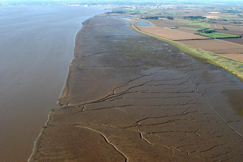
Mud flats along the humber estuary
Web: http://www.pbase.com/clements/image/50216514
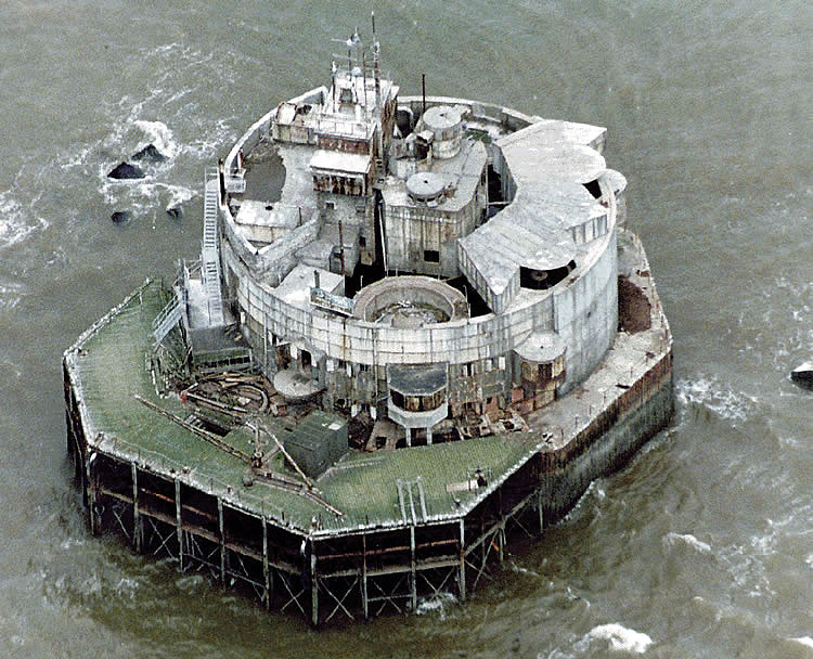
Bull sand fort
Web: http://gallery.nen.gov.uk/image89342-myths.html
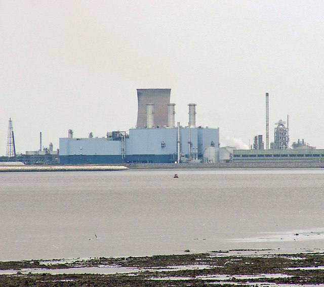
Saltend power station
Web: http://en.wikipedia.org/wiki/File:Saltend_Power_Station_seen_from_Goxhill_Haven.jpg

Cleethorpes pleasure beach
Web: http://www.nelincs.gov.uk/NR/rdonlyres/155CB353-9D13-4B5F-BCF7-AC2973CEACB0/0/promenade.jpg
