
England's Historic Seascapes: Withernsea to Skegness
Museum of London Archaeology, 2010. https://doi.org/10.5284/1000104. How to cite using this DOI
Data copyright © Historic England unless otherwise stated
This work is licensed under the ADS Terms of Use and Access.


Primary contact
David
Bowsher
Director of Research
Museum of London Archaeology
Mortimer Wheeler House
46 Eagle Wharf Road
London
N1 7ED
UK
Tel: 020 7410 2285
Resource identifiers
- ADS Collection: 935
- ALSF Project Number: 4730
- DOI:https://doi.org/10.5284/1000104
- How to cite using this DOI
The Binks Character Area
Present Day Form
The Binks character area is located in the western part of the study area, just off the Spurn Point character area. It includes both intertidal and offshore zones. The Geology of the area is glacial moraine ridge, chalk and boulder clay. Alluviul deposits are also present.
The Binks contains an undulating and pocketed drying area, sometimes called 'Stoney Binks', that extends north-eastwards from the tip Spurn Point. The unevenness of the sand indicates rough tidal flows. The Binks is located on the very edge of the Humber Estuary mouth and the history of its evolution is very closely connected with that of neighbouring Spurn Point.
Sea Use: Present
The area is a navigation hazard, due to the shifting sand and strong tidal currents in the area. It consists of named sand and gravel shoals The Binks, the Outer Binks and Chequer Shoal. The hazardous nature of the area is confirmed by the presence of a number of wreck clusters, some of which are named.
The seabed features in the area are probably related to Spurn Point and may have been earlier versions of the point, in one of its previous 250 year lifecycles (see Spurn Point character area description for more info).
Fishing also takes place in the area, in particular for crab and lobster, although this is restricted at certain times of the year.
Sea Use: Past
The crab and lobster fishing industries known from the area appear to be of some antiquity but it is not possible to state in which period the practice may have originated. It is thought that they may date back as far as the medieval period.
It is probable that the area that is now the beach would have previously been located further inland as the coastline would have been further to the east in the medieval period and earlier. The area may have been dry land from the Roman period onwards. In addition to this it has been shown that Spurn Point has a 250 year life span and so some areas of The Binks may have been dry land only 250 years ago.
The relatively shallow nature of the sea bed means that the area would also have been dry land in the Upper Palaeolithic, Mesolithic. Marine traffic would have historically used this area because of its proximity to the Humber navigation channel. Numerous wrecks will be found here possibly dating from the Roman period onwards.
There is also a vast archive of stories and folk songs describing sailing incidents that happened in the area of The Binks. For example see www.yorkshirefolksong.net/ for more info.
Archaeological Potential
The Binks character area has potential for the presence of drowned land surfaces resulting from the fact that sea level has fluctuated between -120 metres and +10 metres over the past 500,000 years. From the period 500,000 BP to 22,000 BP (before present), human population levels were low, and little more than stray finds may be expected, although these may still be of considerable archaeological importance.
From 22,000 BP to 2100 BP parts of the North Sea were dry land and human population levels were higher, especially in the Mesolithic age. Finds dating to the Mesolithic have been found to a depth of 40m so any area of sea bed above that has potential for habitation.
Inundation of the North Sea landscapes occurred between 10,000 and 6,000 BP and the most likely evidence for human occupation would be, therefore, Mesolithic in date. Earlier Palaeolithic occupation is less likely to be found and later Neolithic occupation is likely to have been limited to the inshore and very highest of the banks and shoals such as the Dogger Bank. The Humber Gateway lies in the position of the Devensian terminal morrain field and it is likely that much of the area was relatively high land but has been subject to severe coastal erosion. This makes it a possible Upper Palaeolithic, Mesolithic and, in the east, Neolithic habitation site. Any residual artefacts, however, would have been eroded and scattered over a wide area by the tidal rip down this coast.
Over the last 6000 years (if not more), humans have used sea faring vessels and this area being close to a navigation channel has many wrecks.
Character Perceptions
The Binks character area is perceived as an important local navigation feature in the Humber Estuary. It is also an intermittent fishing ground.
References
Suddaby, C, P, 1997 Defending your livelihood with little time, no money and few rights, web publication:
http://www.hull.ac.uk/cems/downloads/WOTS_suddaby.pdf
Punnett, N, 2000 Coastal erosion - back to nature in Geofile online, September 2000, web publication:
http://www.hull.ac.uk/coastalobs/general/erosionandflooding/erosion.html
Images
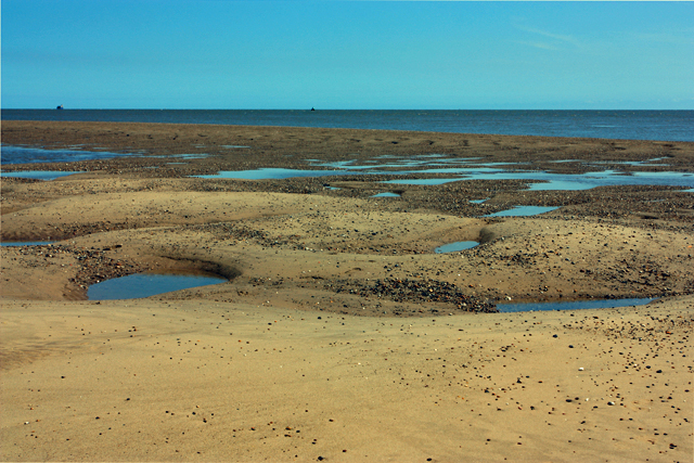
The Binks at low tide
Web: http://www.geograph.org.uk/photo/1352992
