
Elms Farm Portfolio Project
Essex County Council, 2015. (updated 2016) https://doi.org/10.5284/1021668. How to cite using this DOI
Data copyright © Essex County Council unless otherwise stated
This work is licensed under the ADS Terms of Use and Access.

Primary contact
Essex County Council
County Hall
Market Road
Chelmsford
CM1 1QH
Resource identifiers
- ADS Collection: 1169
- DOI:https://doi.org/10.5284/1021668
- How to cite using this DOI

Downloads
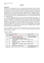
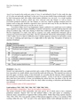
Area Stratigraphy and Phasing Reports
Reports
|
Stratigraphy and Phasing: Area D. | 410 Kb | |
|
Stratigraphy and Phasing: Area E. | 260 Kb | |
|
Stratigraphy and Phasing: Area F. | 385 Kb | |
|
Stratigraphy and Phasing: Area G. | 370 Kb | |
|
Stratigraphy and Phasing: Area H. | 695 Kb | |
|
Stratigraphy and Phasing: Area I. | 500 Kb | |
|
Stratigraphy and Phasing: Area J. | 1 Mb | |
|
Stratigraphy and Phasing: Area K. | 326 Kb | |
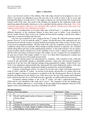
|
Stratigraphy and Phasing: Area L. | 403 Kb | |
|
Stratigraphy and Phasing: Area M. | 429 Kb | |
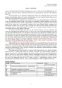
|
Stratigraphy and Phasing: Area N. | 363 Kb | |
|
Stratigraphy and Phasing: Area P. | 290 Kb | |
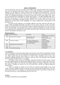
|
Stratigraphy and Phasing: Area Q. | 277 Kb | |
|
Stratigraphy and Phasing: Area R. | 292 Kb | |
|
Stratigraphy and Phasing: Area W. | 404 Kb |
