
Essex Aggregates Archaeology Resource Assessment
Essex County Council, 2011. https://doi.org/10.5284/1000425. How to cite using this DOI
Data copyright © Essex County Council, English Heritage unless otherwise stated
This work is licensed under the ADS Terms of Use and Access.


Primary contact
Paul
Gilman
Heritage Information & Records
Essex County Council
County Hall
Market Road
Chelmsford
CM1 1QH
Resource identifiers
- ADS Collection: 1087
- ALSF Project Number: 5841
- DOI:https://doi.org/10.5284/1000425
- How to cite using this DOI

Introduction
This report provides the results of an assessment of the archaeological resource threatened by the extraction of aggregate minerals within Essex. The assessment was carried out between April 2010 and February 2011 by the Historic Environment Branch of Essex County Council. The assessment comprised a range of projects located within the historic aggregate areas of the County. These included:-
Update of Historic Environment Record: A programme of updating the Historic Environment Record ensured that the Historic Environment advice provided to the MDD consultation was the most up to date and accurate.
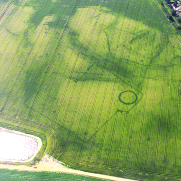
Aerial photographic interpretation: In the aggregates-rich areas this data was enhanced through the digitisation of cropmarks from aerial photographs as part of English Heritage's National Mapping Programme (NMP).
Braintree Historic Environment Characterisation: Through the provision of combined Historic Environment Characterisation data for the main mineral-bearing areas of Essex, the County Council planners, with support from their specialist advisors, will be able to integrate the conservation and management of the historic environment assets both within Mineral Development Frameworks and in turn support the creation of a series of Mineral Development Documents.
Mineral Development Assessment Sheet: The mineral assessment sheet created as part of this project will allow the County Council Planners to be provided with detailed information on all elements of the Historic Environment for the separate sites submitted for consideration for the MDD. Sheets have also been produced for all of the ROMP sites using the same sheet.
