
The Archaeological Landscape of Frampton on Severn, Gloucestershire
Gloucestershire County Council, 2014. https://doi.org/10.5284/1025046. How to cite using this DOI
Data copyright © Gloucestershire County Council unless otherwise stated
This work is licensed under the ADS Terms of Use and Access.


Primary contact
Toby
Catchpole
Archaeology Service
Gloucestershire County Council
Shire Hall
Westgate Street
Gloucester
GL1 2TH
England
Tel: 01452 425681
Fax: 01452 425356
Resource identifiers
- ADS Collection: 1619
- ALSF Project Number: 4625
- ALSF Project Number: 5171
- DOI:https://doi.org/10.5284/1025046
- How to cite using this DOI

Introduction
This archive results from the combination of two ALSF projects.
The Archaeological Landscape of Frampton on Severn (ALSF 4625)
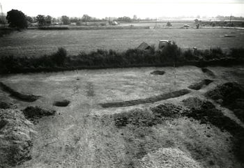
Gravel extraction in Frampton on Severn and adjacent parishes during the twentieth century resulted in the collection of archaeological finds, very few of which had been adequately published. In particular the excavation of five ring ditches at Netherhills Quarry, directed by Richard Atkinson in 1948, had not been written up.
The project involved the examination of the (partial) Atkinson archive and of other finds from the area held in Stroud and Gloucester Museums, in order to publish Atkinsonâs excavations in their landscape context. It also included the mapping and recording of archaeological features visible on available aerial photographs as part of the English Heritage National Mapping Programme.
Netherhills Quarry, Frampton on Severn (ALSF 5171)
While project 4625 was underway Netherhills Quarry was extended into an area south of that excavated by Atkinson. The quarry had old planning permissions, lacking any archaeological condition, and English Heritage provided PPG16 Assistance funding through the ALSF that allowed GCCAS to undertake an evaluation in November 2006, and then 'salvage' excavations in early 2007. This revealed further evidence for prehistoric activity spanning the Neolithic and Bronze Age as well as later features.
