
Hampshire - assessment of archaeological resource in aggregate areas
Cornwall Council, 2008. (updated 2010) https://doi.org/10.5284/1000048. How to cite using this DOI
Data copyright © Cornwall Council, Hampshire County Council unless otherwise stated
This work is licensed under the ADS Terms of Use and Access.


Primary contact
Andrew
Young
Historic Environment Service
Cornwall Council
Kennall Building, Old County Hall
Station Road
Truro
TR1 3AY
UK
Tel: 01872 322654
Fax: 01872 323 811
Resource identifiers
- ADS Collection: 880
- ALSF Project Number: 4766
- DOI:https://doi.org/10.5284/1000048
- How to cite using this DOI
Introduction
The 'Hampshire - assessment of archaeological resource in aggregate areas' project was initially undertaken between March 2006 and March 2008. The project comprised a survey and assessment of the archaeology of the aggregate mineral producing areas within the county of Hampshire. It was carried out by the Historic Environment Service of Cornwall County Council (CCC) in partnership with the Environment Department of Hampshire County Council (HCC). It was funded under Objective 2 of the Aggregates Levy Sustainability Fund (ALSF) as distributed by English Heritage. A second phase of the project (5783) was later commissioned, and comprised an archaeological survey of the New Forest and North West Solent coastal plain based on a review of all available aerial photographs and Environment Agency LiDAR data. It was carried out between March 2009 and January 2010.
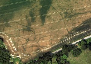
The assessment consists of a consideration of the archaeology within the aggregate producing areas of the county through analysis of data contained in the Hampshire Archaeology and Historic Buildings Record (AHBR). In nine of these areas AHBR data was enhanced through systematic mapping from aerial photographs as part of English Heritage's National Mapping Programme (NMP).
The project outcome includes the formulation of a Resource Assessment and Research Agenda for the aggregate landscapes of Hampshire. These highlight gaps in knowledge of the archaeological resource, the research potential of the resource, and the identification of prioritised research topics. The agenda will feed into the regional Solent Thames Research Framework, which is currently being formulated.
