
Home Front Legacy 1914-18
Claire Corkill, Chris Kolonko, 2020. https://doi.org/10.5284/1059297. How to cite using this DOI
Data copyright © Council for British Archaeology unless otherwise stated
This work is licensed under a Creative Commons Attribution 4.0 International License.

Primary contact
Council for British Archaeology
92 Micklegate
York
YO1 6JX
UK
Tel: 01904 671417
Resource identifiers
- ADS Collection: 3366
- DOI:https://doi.org/10.5284/1059297
- How to cite using this DOI

Full Record - Auburn Farm Pillbox (PRN: 10522)
| PRN | 10522 | ||||
|---|---|---|---|---|---|
| Site or location name | Auburn Farm Pillbox | ||||
| Summary | |||||
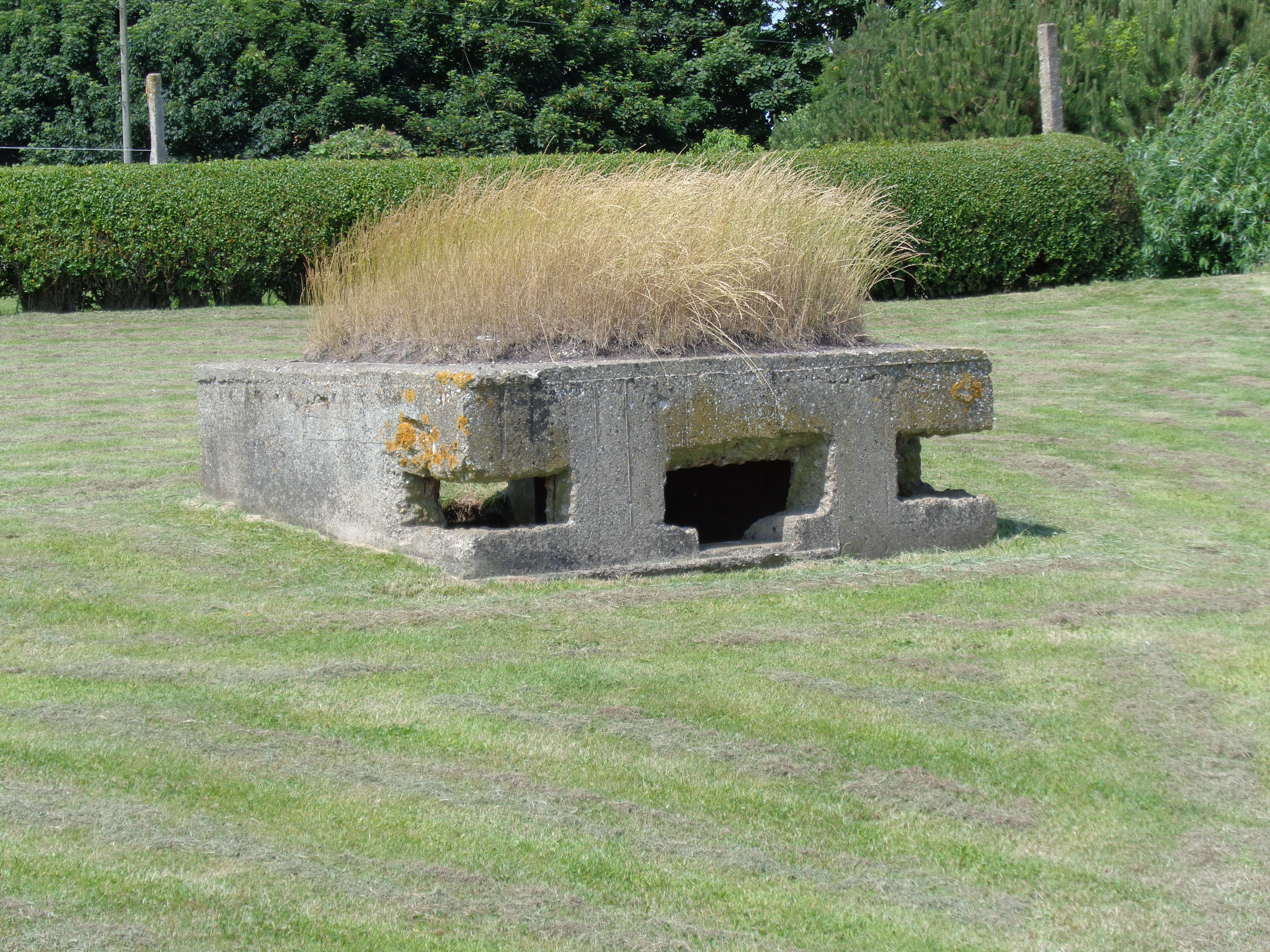
| Description | First World War pillbox located to the West of Auburn Sands/Fraisthorpe Beach. This 'square type' pillbox faces East, covering the nearby beach exit. The pillbox is 247cm x 247cm square with walls 25cm thick. The walls are substantially thicker than other examples in the area (which are approximately 15cm thick). However, they would not be considered 'bullet proof standard' during the Second World War. It is believed that this pillbox would accommodate a machine gun, possibly a Vickers Heavy Machine Gun. However, the original loophole would have also allowed a rifle to be fired from the same position. The pillbox was deliberately constructed in a semi-sunken configuration, ensuring the pillbox's silhouette was reduced, further concealing the position and protecting it from incoming fire. The pillbox was re-used during the Second World War with additional loopholes cut in the North-East & South-East corners and the original loophole being significantly altered to allow a greater field of fire to the East. This pillbox represents a rare survival of a First World War coastal defence system employed to protect the coast of East Yorkshire. This pillbox is now Grade II listed-historicengland.org.uk/listing/the-list/list-entry/1442123 | ||||
| Monument Type | PILLBOX;PILLBOX | ||||
| Desgination | None | ||||
| Material | CONCRETE | ||||
| Location | |||||
| Country | ENGLAND | ||||
|---|---|---|---|---|---|
| County | Fraisthorpe | ||||
| Site Location | Auburn Farm Pillbox | ||||
| Postcode | |||||
| Map Reference | NGR: TA1686762781 (516867, 462781) | ||||
| Condition/Threat | |||||
| Condition (Date) | Good (27-11-2017) | ||||
| Threat | Encroaching development | ||||
| Signif | Low | ||||
| Source | |||||
| Brigham, T/Humber Field Archaeology (2014) Rapid Coastal Zone Assessment Survey Yorkshire and Lincolnshire: Phase 3 Project Overview. Thematic Discussion of Selected Aspects.. Historic England. Portsmouth. 422 https://research.historicengland.org.uk/Report.aspx?i=15629 | |||||
| Administration | |||||
| Recorded By (Date) | Chris Kolonko - Home Front Legacy (11-07-2015) | ||||
| Copiled On | 27-11-2017 | ||||
| Last Updated | 10-01-2018 | ||||
| Associated data |
|---|
Documentation
| Image metadata | CSV | 590 Kb |
Data
. Image taken facing North West. Image taken 11.07.2015 as a JPG image")
|
Auburn Farm Pillbox (Fraisthorpe, East Riding of Yorkshire). Image taken facing North West. Image taken 11.07.2015 (File name: 10522_1159.jpg) |
JPG | 7.90 Mb |
. Interior. Image taken: 10.06.2017 as a JPG image")
|
Auburn Farm Pillbox (Fraisthorpe, East Riding of Yorkshire). Interior. Image taken: 10.06.2017 (File name: 10522_1160.jpg) |
JPG | 7.86 Mb |
