
Home Front Legacy 1914-18
Claire Corkill, Chris Kolonko, 2020. https://doi.org/10.5284/1059297. How to cite using this DOI
Data copyright © Council for British Archaeology unless otherwise stated
This work is licensed under a Creative Commons Attribution 4.0 International License.

Primary contact
Council for British Archaeology
92 Micklegate
York
YO1 6JX
UK
Tel: 01904 671417
Resource identifiers
- ADS Collection: 3366
- DOI:https://doi.org/10.5284/1059297
- How to cite using this DOI

Full Record - unknown (PRN: 11458)
| PRN | 11458 | ||||
|---|---|---|---|---|---|
| Site or location name | unknown | ||||
| Summary | |||||
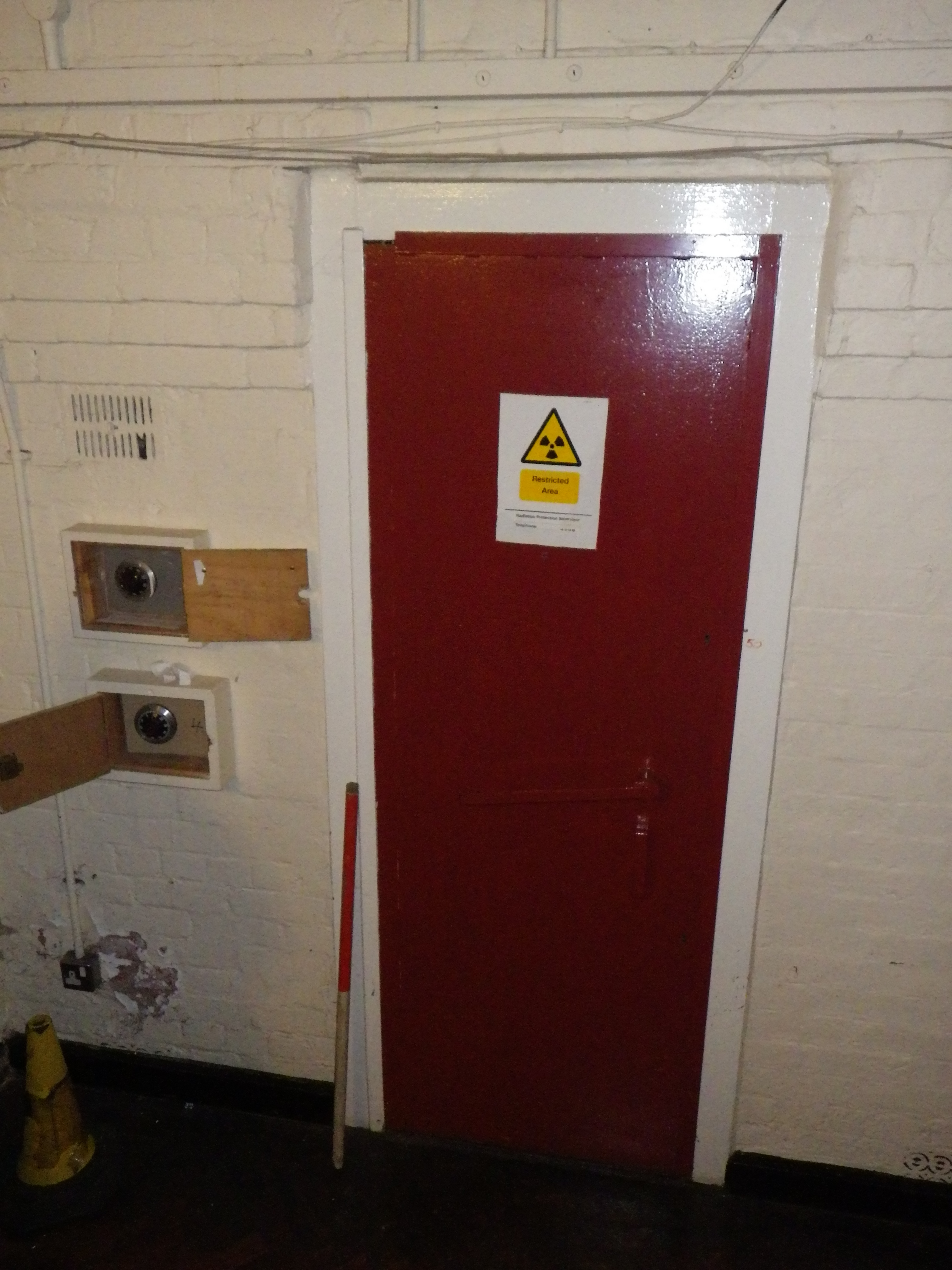
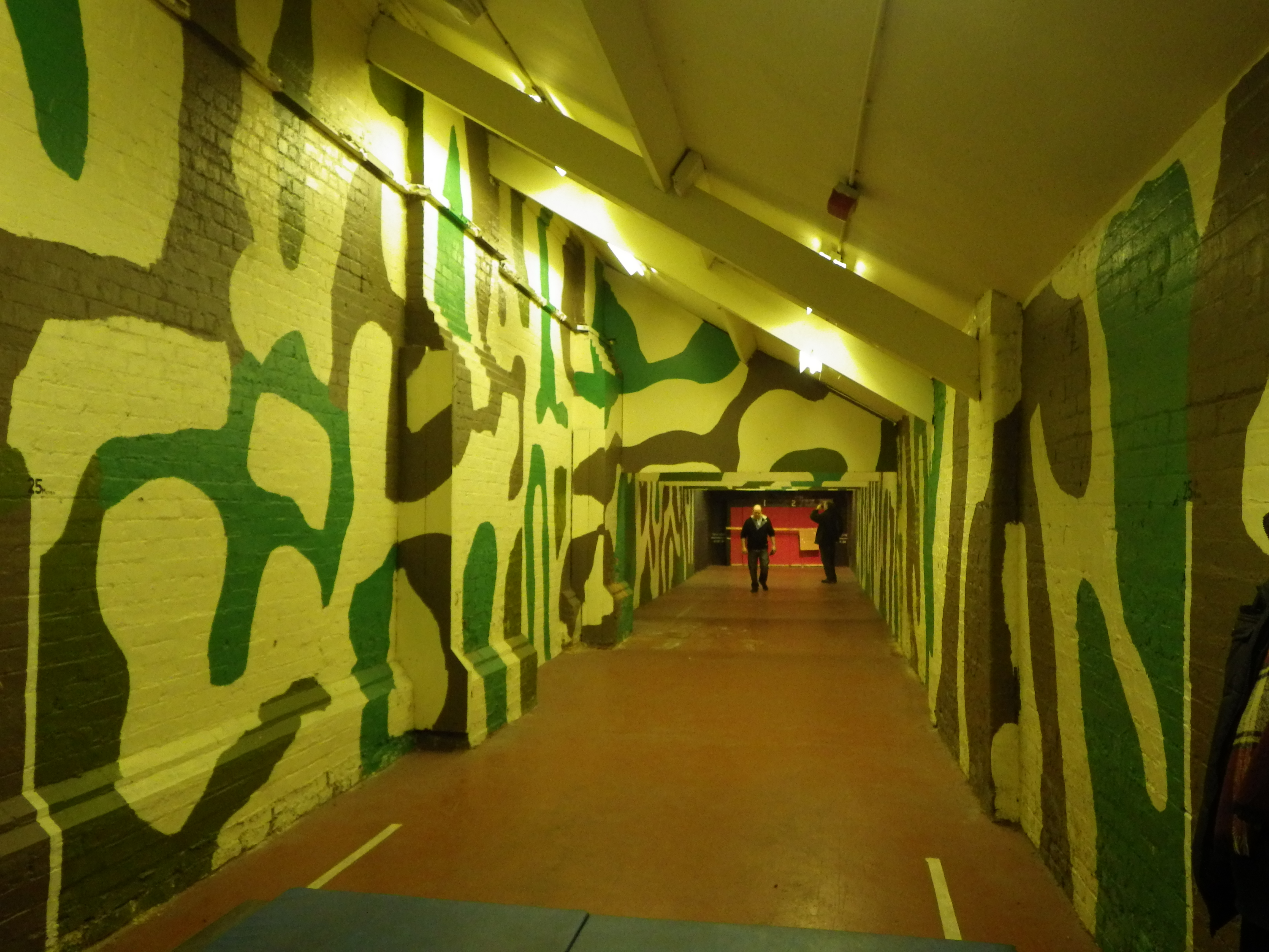
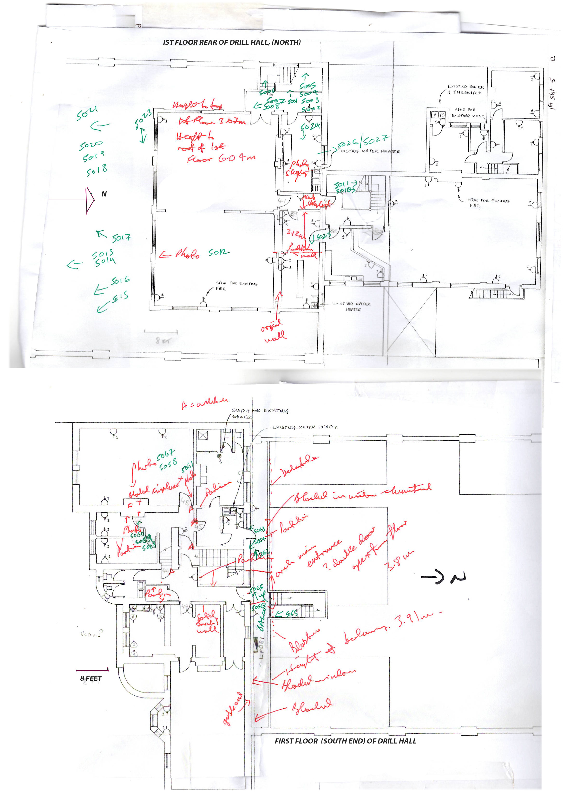
| Description | Significant alteration inside main building. False ceiling to main drill hall. Drill hall now contains 3 portable structures acting as offices/kitchen. Original sotrage rooms unchanged. Front entrance had a large double gated entrance to allow guns/horse entry similiar to bricked in rear entrance(to north). Viewing areas on first floor to each end of the drill hall one open and one closed in. One a officers bar(North end). Rifle range unmodified on the east side of the building with associated strong storage rooms with gun blast door. Front of building contains offices on two floors and toilets (? post WW1). Main building extended on west side (post WW1). Attached brick building to rear presently caretaker with direct access. Front wall (south) has coal chute to cellars, possible original boiler room. Post WW1 boiler room now on west wall mid drill hall. Main drill hall floor looks original, with drill hall clock south facing wall and asscoiated WW1 memorabilla. First floor at front of building contains a post WW1 small bar for TA members, bar contains glass doors from the pub opposite used during WW1. Building has one flag bearing tower with staircase. Main building contains upright iron column supports dated 1886 Derby & London to support roof structure. Building used by AIr Cadets. | ||||
| Monument Type | TRAINING CENTRE;GUN STORE;TRAINING CENTRE | ||||
| Desgination | None | ||||
| Material | BRICK, IRON | ||||
| Location | |||||
| Country | ENGLAND | ||||
|---|---|---|---|---|---|
| County | Ashton under lyne | ||||
| Site Location | unknown | ||||
| Postcode | OL6 7SG | ||||
| Map Reference | NGR: SJ93569895 (393560, 398950) | ||||
| Condition/Threat | |||||
| Condition (Date) | Fair (27-07-2018) | ||||
| Threat | Encroaching development | ||||
| Signif | Moderate | ||||
| Related Sites | |||||
| Ashton Armoury 178 | |||||
| Source | |||||
| Ordnance Survey (1923) Lancashire CV (includes: Ashton Under Lyne; Audenshaw; Denton; Dukinfield; Hurst; Hyde). National Library of Scotland . Edinburgh. https://maps.nls.uk/view/102344090 | |||||
| Edwards Dewhurst Ltd (1995) Plan1 with TAS survey 2016. | |||||
| Edwards Dewhurst Ltd (1995) Plan2 with TAS survey 2016. | |||||
| (1915) [article]. The Reporter | |||||
| Administration | |||||
| Recorded By (Date) | Kevin Wright - Tameside Archaeological Society Ltd (01-02-2016) | ||||
| Copiled On | 27-07-2018 | ||||
| Last Updated | 27-07-2018 | ||||
| Associated data |
|---|
Documentation
| Image metadata | CSV | 590 Kb |
| Text metadata | CSV | 14 Kb |
Data
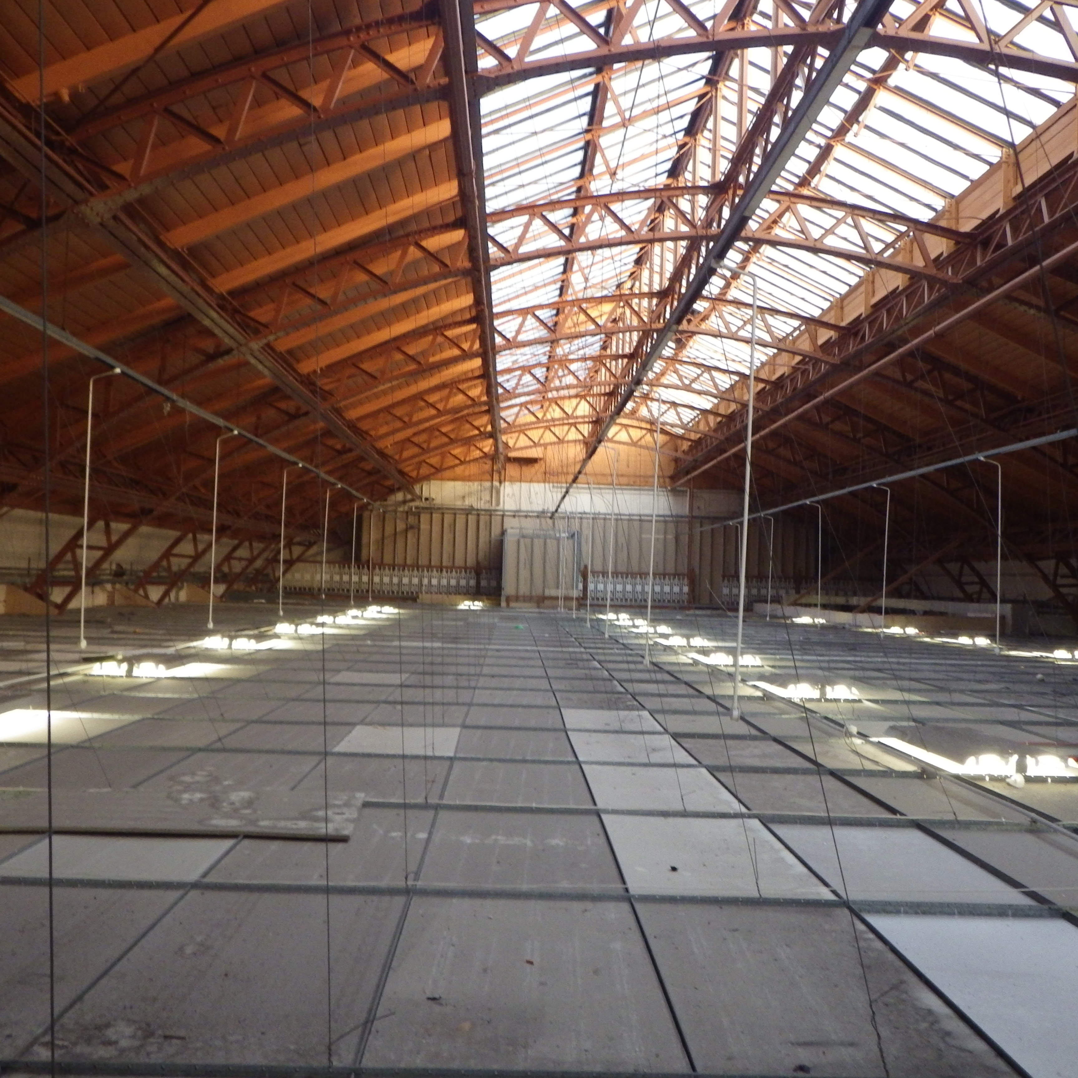
. Belfast roof structure. as a JPG image")
|
Former training centre at Old Street Drill Hall (Cavendish Street, Ashton-under-Lyne). Belfast roof structure. (File name: 11458_1266.jpg) |
JPG | 3.72 Mb |
. Double. as a JPG image")
|
Former training centre at Old Street Drill Hall (Cavendish Street, Ashton-under-Lyne). Double. (File name: 11458_1264.jpg) |
JPG | 4.27 Mb |
. Indoor Rifle range. as a JPG image")
|
Former training centre at Old Street Drill Hall (Cavendish Street, Ashton-under-Lyne). Indoor Rifle range. (File name: 11458_1265.jpg) |
JPG | 4.37 Mb |
. Plan1 with Tees Archaeology Society Survey 2016. as a JPG image")
|
Former training centre at Old Street Drill Hall (Cavendish Street, Ashton-under-Lyne). Plan1 with Tees Archaeology Society Survey 2016. (File name: 11458_2983.jpg) |
JPG | 11.15 Mb |
. Plan2 with Tees Archaeology Society Survey 2016. as a JPG image")
|
Former training centre at Old Street Drill Hall (Cavendish Street, Ashton-under-Lyne). Plan2 with Tees Archaeology Society Survey 2016. (File name: 11458_2984.jpg) |
JPG | 1.59 Mb |
| National Library of Scotland, Ordnance Survey (1923) Lancashire CV (includes: Ashton Under Lyne; Audenshaw; Denton; Dukinfield; Hurst; Hyde). | 1 Mb | ||

|
Training centre at Cavendish Street, Ashton-under-Lyne. (File name: 11458_1267.jpg) |
JPG | 4.06 Mb |
