
Home Front Legacy 1914-18
Claire Corkill, Chris Kolonko, 2020. https://doi.org/10.5284/1059297. How to cite using this DOI
Data copyright © Council for British Archaeology unless otherwise stated
This work is licensed under a Creative Commons Attribution 4.0 International License.

Primary contact
Council for British Archaeology
92 Micklegate
York
YO1 6JX
UK
Tel: 01904 671417
Resource identifiers
- ADS Collection: 3366
- DOI:https://doi.org/10.5284/1059297
- How to cite using this DOI

Full Record - Larkhill Army Camp RailwayTerminus (PRN: 11463)
| PRN | 11463 | ||||
|---|---|---|---|---|---|
| Site or location name | Larkhill Army Camp RailwayTerminus | ||||
| Summary | |||||
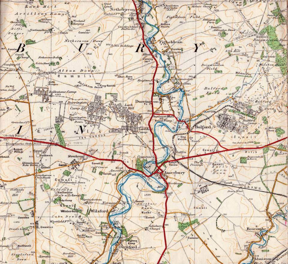
| Description | This was the approximate location of the Larkhill Military Railway Terminus serving the Camp. The track ran next to the Packway on the north-side of the road, and lay just inside of the current camp. It is shown on the 1920 issue of the Military Edition of the Salisbury Plain Map.' | ||||
| Monument Type | RAILWAY WORKS;RAILWAY WORKS | ||||
| Desgination | None | ||||
| Material | |||||
| Location | |||||
| Country | ENGLAND | ||||
|---|---|---|---|---|---|
| County | |||||
| Site Location | Larkhill Army Camp RailwayTerminus | ||||
| Postcode | |||||
| Map Reference | NGR: SU12794428 (412790, 144280) | ||||
| Condition/Threat | |||||
| Condition (Date) | Destroyed (28-07-2018) | ||||
| Source | |||||
| (1920) Salisbury Plain Artillery Ranges Map Military Edition. Ordnance Survey. | |||||
| (2005) Return to Larkhill. Sheetlines (Charles Close Society). London. 72 (pp23-25). https://www.charlesclosesociety.org/ | |||||
| Administration | |||||
| Recorded By (Date) | Tim Darch - Salisbury Plain Training Area | ||||
| Copiled On | 28-07-2018 | ||||
| Last Updated | 28-07-2018 | ||||
| Associated data |
|---|
Documentation
| Image metadata (scanned documents) | CSV | 36 Kb |
Data
. Salisbury Plain Artillery Ranges Map Military Edition. as a JPG image")
|
Larkhill Army Camp RailwayTerminus (The Packway, Durrington, Larkhill, Wiltshire). Salisbury Plain Artillery Ranges Map Military Edition. (File name: 11463_2994.jpg) |
JPG | 198 Kb |
| Charles Close Society (nd) Return to Larkhill. Charles Close Society | 526 Kb | ||
