
Home Front Legacy 1914-18
Claire Corkill, Chris Kolonko, 2020. https://doi.org/10.5284/1059297. How to cite using this DOI
Data copyright © Council for British Archaeology unless otherwise stated
This work is licensed under a Creative Commons Attribution 4.0 International License.

Primary contact
Council for British Archaeology
92 Micklegate
York
YO1 6JX
UK
Tel: 01904 671417
Resource identifiers
- ADS Collection: 3366
- DOI:https://doi.org/10.5284/1059297
- How to cite using this DOI

Full Record - Downs Haven Shelter, Blackboy Hill, Bristol (WWI convalescent shelter) (PRN: 120)
| PRN | 120 | ||||
|---|---|---|---|---|---|
| Site or location name | Downs Haven Shelter, Blackboy Hill, Bristol (WWI convalescent shelter) | ||||
| Summary | Durdham Downs Shelter | ||||
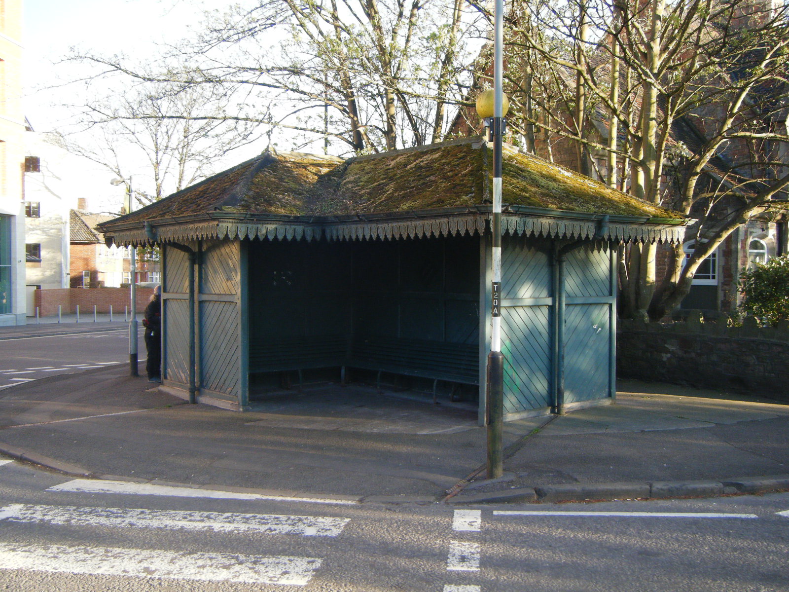
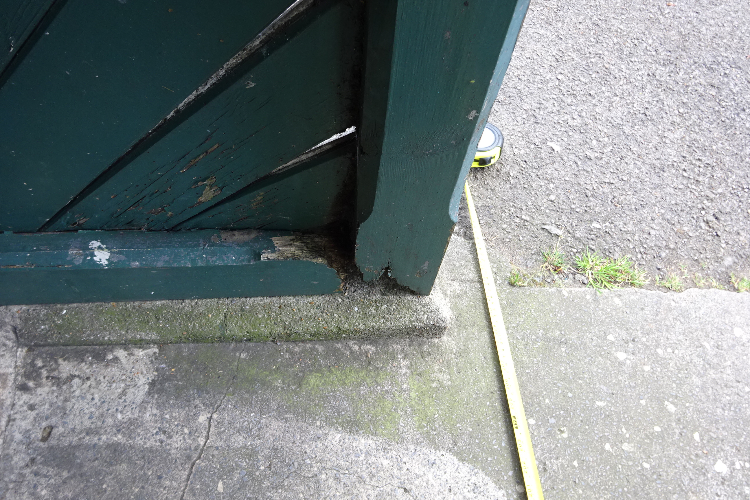
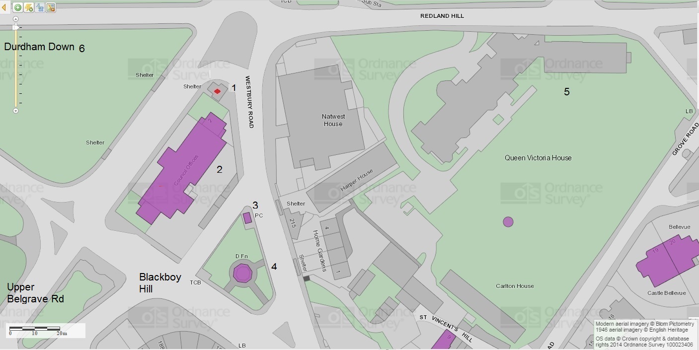
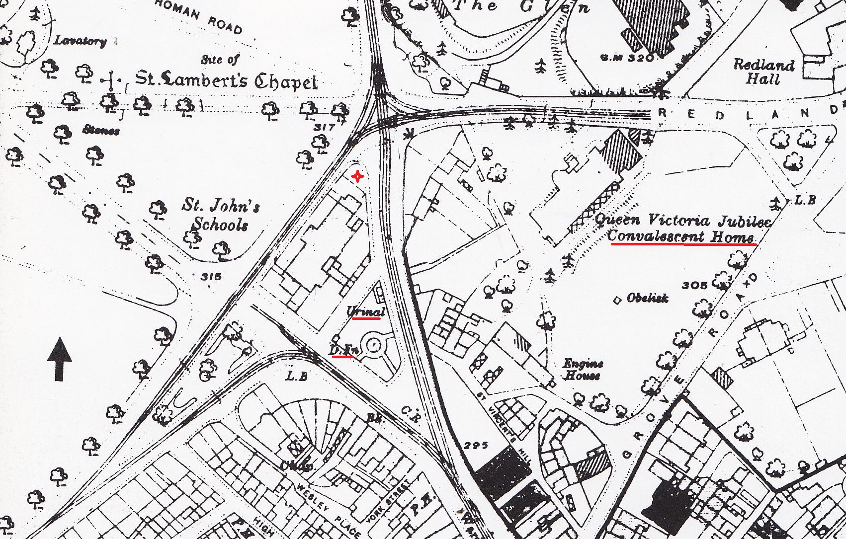
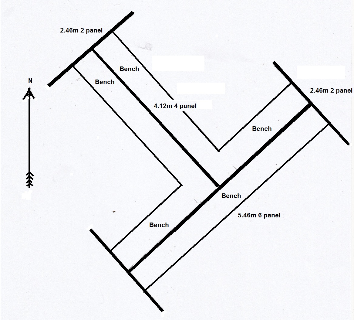
| Description | 'Location: The setting is provided by a numbered 2015 map (image mapn.jpg) showing the location of the shelter (1), the Old School (2), public urinal (3), drinking fountain (4) and Convalescent Home (5) in relationship to the Downs (6) . It also shows the group of listed buildings on the island. The map can be compared with a 1913 map (image map1913.jpg). The convalescent only needed to walk 100 yards from the Home to the shelter by crossing the Westbury Road, to get a break and change of scenery in a sheltered place away from the wind and rain with three independent sides to choose. This would have been an alternative to the large gardens of the Home and slightly further afield. No shelter is shown in the Ordnance survey map from 1913 (map1913.jpg) so there was no cabmans shelter here before. The urinal and fountain are shown. The fountain was not installed until 1904. Tram lines can be seen in Redland Hill, Upper Belgrave Road, Westbury Road and Blackboy Hill. Durdham Down tramway terminus where road island is now. This was a good location for a shelter. Trams, cars, cabs, delivery vehicles, the downs and passers by could be observed instead of nurses and injured people. Orientation: A large symmetrical T shaped ornamental wooden structure with north, south and east entrances to three wooden slatted benches well sheltered from the weather by large panels. It is in very good condition. The north west side is more secluded than the others. Dimensions: Sectional Plan is provided giving dimensions and shows how people are sheltered by side panels. Internal Height 2.15m. Total Height 4.15m. South east length 5.46m, north west length 4.12m, side panels 2.46m Function and Setting: The shelter was built by public subscription, during the first world war to provide shelter for convalescent servicemen and women from the nearby Queen Victoria Hospital.' | ||||
| Monument Type | COMMEMORATIVE MONUMENT;SICK QUARTERS;COMMEMORATIVE MONUMENT | ||||
| Desgination | None | ||||
| Material | WOOD, CAST IRON | ||||
| Location | |||||
| Country | ENGLAND | ||||
|---|---|---|---|---|---|
| County | Clifton East. The site is within the Durdham Down | ||||
| Site Location | A public shelter sited on a large roundabout with junctions leading to Upper Belgrave Road to the south west (which leads to the Zoo), Blackboy Hill to the south east, Westbury Road to the east, Stoke | ||||
| Postcode | BS8 2AY? | ||||
| Map Reference | NGR: ST57347488 (357340, 174880) | ||||
| Condition/Threat | |||||
| Condition (Date) | Good (07-06-2015) | ||||
| Threat | Delapidation | ||||
| Signif | Moderate | ||||
| Source | |||||
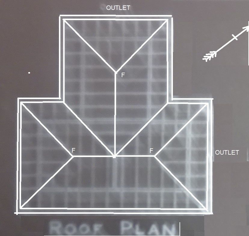
| Bristol Corporation Engineers (1916) Roof Plan 1 December 1916. Bristol Corporation Engineers Department. Shows rainwater outlets (Bristol Records Office Plans 42054.G.Drawer 4/16959-16963). | |||||
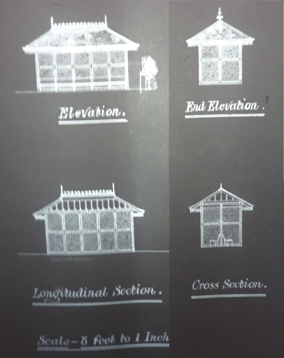
| Bristol Corporation Engineers (1916) Section Plan 1 December 1916. Bristol Corporation Engineers Department. Shows fascia board ornamentation, finials and ridge tiles (no longer present) as well as chevron patterned panels and seat construction in the elevations and cross section. Bristol Re. | |||||
| Davey, Peter (1995) British Tramways. Ordnance Survey map obtained from Peter Davey's 'Bristol's Tramways book' plate 10 (which also gives a photograph of the site in 1938). The introduction states that the ordnance survey maps are to the scale of 1 in 2500 and date from 1903 to 1913.. Midhurst. Middleton. https://maps.bristol.gov.uk/pinpoint/ | |||||
| (2015) Ordnance Survey 2015 map with numbers added showing the location of the shelter (1), the Old School (2), public urinal (3), drinking fountain (4) and Convalescent Home (5) in relationship to the Downs (6) Produced using website https://maps.bristol.gov.uk/pinpoint/.. Bristol City Council/Getmapping/English Heritage/Crown Copyright. Bristol. https://maps.bristol.gov.uk/pinpoint/ | |||||
| Shapland, Maggie (2015) Sectional Plan giving dimensions and shows how people sheltered by side panels. Internal Height 2.15m. Total Height 4.15m. South east length 5.46m, north west length 4.12m, side panels 2.46m. . | |||||
| King, SJ (1917) A War Memorial. Western Daily Press | |||||
| Administration | |||||
| Recorded By (Date) | Maggie Shapland - Clifton and Hotwells Improvement Society | ||||
| Copiled On | 07-06-2015 | ||||
| Last Updated | 07-06-2015 | ||||
| Associated data |
|---|
Documentation
| Image metadata | CSV | 590 Kb |
| Image metadata (scanned documents) | CSV | 36 Kb |
Data
. as a JPG image")
|
Downs Haven Shelter, also Durdham Downs Shelter (Upper Belgrave Road/Blackboy Hill/Westbury Road, Durdham Down, Bristol). (File name: 120_193.jpg) |
JPG | 558 Kb |
. as a JPG image")
|
Downs Haven Shelter, also Durdham Downs Shelter (Upper Belgrave Road/Blackboy Hill/Westbury Road, Durdham Down, Bristol). (File name: 120_194.jpg) |
JPG | 1.91 Mb |
. Ordnance Survey 2015 map with numbers added showing the location of the shelter (1), the Old School (2), public urinal (3), drinking fountain (4) and Convalescent Home (5) in relationship to the Downs (6) Produced using website maps.bristol.gov.uk pinpoin as a JPG image")
|
Downs Haven Shelter, also Durdham Downs Shelter (Upper Belgrave Road/Blackboy Hill/Westbury Road, Durdham Down, Bristol). Ordnance Survey 2015 map with numbers added showing the location of the shelter (1), the Old School (2), public urinal (3), drinking fountain (4) and Convalescent Home (5) in relationship to the Downs (6) Produced using website maps.bristol.gov.uk pinpoin (File name: 120_107.jpg) |
JPG | 202 Kb |
. Ordnance Survey map obtained from Peter Davey's 'Bristol's Tramways book' plate 10 (which also gives a photograph of the site in 1938). The introduction states that the ordnance survey maps are to the scale of 1 in 2500 and date from 1903 to 1913. The fou as a JPG image")
|
Downs Haven Shelter, also Durdham Downs Shelter (Upper Belgrave Road/Blackboy Hill/Westbury Road, Durdham Down, Bristol). Ordnance Survey map obtained from Peter Davey's 'Bristol's Tramways book' plate 10 (which also gives a photograph of the site in 1938). The introduction states that the ordnance survey maps are to the scale of 1 in 2500 and date from 1903 to 1913. The fou (File name: 120_108.jpg) |
JPG | 892 Kb |
. Ornamental palmette cast iron fascia on overhanging eaves. as a JPG image")
|
Downs Haven Shelter, also Durdham Downs Shelter (Upper Belgrave Road/Blackboy Hill/Westbury Road, Durdham Down, Bristol). Ornamental palmette cast iron fascia on overhanging eaves. (File name: 120_196.jpg) |
JPG | 1.81 Mb |
. Roof Plan 1 December 1916. Bristol Corporation Engineers Department. Shows rainwater outlets. Bristol Records Office Plans 42054.G.Drawer 4/16959-16963 as a JPG image")
|
Downs Haven Shelter, also Durdham Downs Shelter (Upper Belgrave Road/Blackboy Hill/Westbury Road, Durdham Down, Bristol). Roof Plan 1 December 1916. Bristol Corporation Engineers Department. Shows rainwater outlets. Bristol Records Office Plans 42054.G.Drawer 4/16959-16963 (File name: 120_109.jpg) |
JPG | 193 Kb |
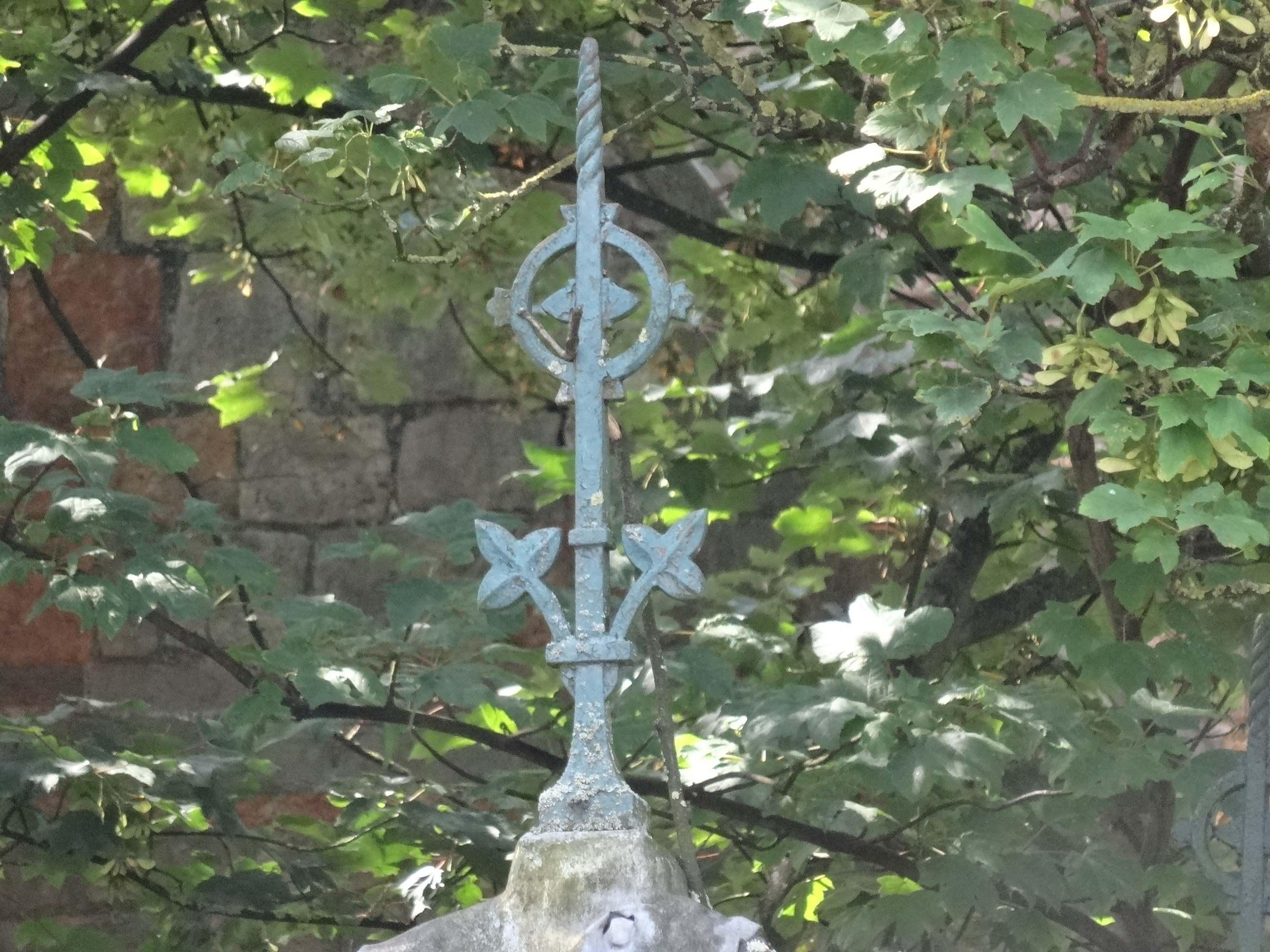
. Roof ridge finial. as a JPG image")
|
Downs Haven Shelter, also Durdham Downs Shelter (Upper Belgrave Road/Blackboy Hill/Westbury Road, Durdham Down, Bristol). Roof ridge finial. (File name: 120_195.jpg) |
JPG | 2.92 Mb |
. Section Plan 1 December 1916. Bristol Corporation Engineers Department. Shows fascia board ornamentation, finials and ridge tiles (no longer present) as well as chevron patterned panels and seat construction in the elevations and cross section. Bristol Re as a JPG image")
|
Downs Haven Shelter, also Durdham Downs Shelter (Upper Belgrave Road/Blackboy Hill/Westbury Road, Durdham Down, Bristol). Section Plan 1 December 1916. Bristol Corporation Engineers Department. Shows fascia board ornamentation, finials and ridge tiles (no longer present) as well as chevron patterned panels and seat construction in the elevations and cross section. Bristol Re (File name: 120_110.jpg) |
JPG | 442 Kb |
. Sectional Plan giving dimensions and shows how people sheltered by side panels. Internal Height 2.15m. Total Height 4.15m. South east length 5.46m, north west length 4.12m, side panels 2.46m. as a JPG image")
|
Downs Haven Shelter, also Durdham Downs Shelter (Upper Belgrave Road/Blackboy Hill/Westbury Road, Durdham Down, Bristol). Sectional Plan giving dimensions and shows how people sheltered by side panels. Internal Height 2.15m. Total Height 4.15m. South east length 5.46m, north west length 4.12m, side panels 2.46m. (File name: 120_111.jpg) |
JPG | 308 Kb |
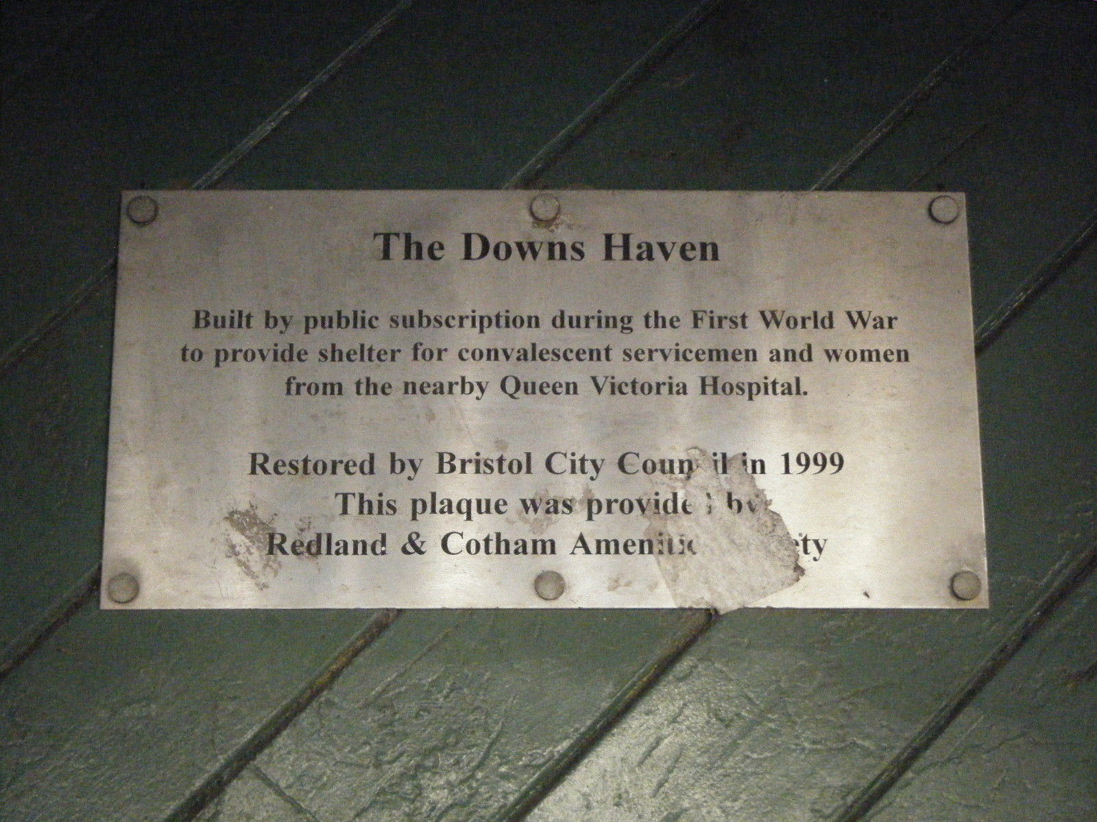
. Sign provided by the Redland and Community Amenity Society confirming the use of the shelter and when it was last restored. as a JPG image")
|
Downs Haven Shelter, also Durdham Downs Shelter (Upper Belgrave Road/Blackboy Hill/Westbury Road, Durdham Down, Bristol). Sign provided by the Redland and Community Amenity Society confirming the use of the shelter and when it was last restored. (File name: 120_197.jpg) |
JPG | 574 Kb |
. Western Daily Press 27 June 1917: Reference to Councillor S..J. King providing the Haven for the comfort of members of H.M. forces. 281 men of the 4th Gloucesters giving their lives. as a JPG image")
|
Downs Haven Shelter, also Durdham Downs Shelter (Upper Belgrave Road/Blackboy Hill/Westbury Road, Durdham Down, Bristol). Western Daily Press 27 June 1917: Reference to Councillor S..J. King providing the Haven for the comfort of members of H.M. forces. 281 men of the 4th Gloucesters giving their lives. (File name: 120_112.jpg) |
JPG | 148 Kb |
