
Home Front Legacy 1914-18
Claire Corkill, Chris Kolonko, 2020. https://doi.org/10.5284/1059297. How to cite using this DOI
Data copyright © Council for British Archaeology unless otherwise stated
This work is licensed under a Creative Commons Attribution 4.0 International License.

Primary contact
Council for British Archaeology
92 Micklegate
York
YO1 6JX
UK
Tel: 01904 671417
Resource identifiers
- ADS Collection: 3366
- DOI:https://doi.org/10.5284/1059297
- How to cite using this DOI

Full Record - Bacton Stokes Mortar Position (PRN: 8238)
| PRN | 8238 | ||||
|---|---|---|---|---|---|
| Site or location name | Bacton Stokes Mortar Position | ||||
| Summary | |||||
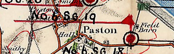
| Description | Site of Stokes Gun Position according to a military map of First World War defences in North Norfolk. The Stokes Mortar, referred to at the time as the 'Stokes Gun', was introduced into service towards the end of 1916 and had a maximum range of 800yds (731m). The mortar was often emplaced in a simple earthwork known as a 'pit'. In this location the Mortar position would have been able to bring down fire onto the beach exit to the North-East, and also the surrounding area. The map on which this defence work is recorded dates from 1918, this emplacement may have been part of the wider defences constructed in the area during 1916. The emplacement is designated 'No.6 S.G. 18', possibly referring to the unit that manned this position. Located on private property. Site not visited; further archive research and field work may reveal more about this defence site. Map reproduced by kind permission of the map's owner, Mr. J. Hall. | ||||
| Monument Type | GUN EMPLACEMENT;DEFENCE WORK;GUN EMPLACEMENT | ||||
| Desgination | None | ||||
| Material | |||||
| Location | |||||
| Country | ENGLAND | ||||
|---|---|---|---|---|---|
| County | |||||
| Site Location | Located to the South of the WW2 Pillbox adjacent Coast Rd., Bacton | ||||
| Postcode | |||||
| Map Reference | NGR: TG3388734048 (633887, 334048) | ||||
| Condition/Threat | |||||
| Condition (Date) | Destroyed (08-08-2016) | ||||
| Administration | |||||
| Recorded By (Date) | Chris Kolonko - Home Front Legacy | ||||
| Copiled On | 08-08-2016 | ||||
| Last Updated | 08-08-2016 | ||||
| Associated data |
|---|
Documentation
| Image metadata | CSV | 590 Kb |
Data
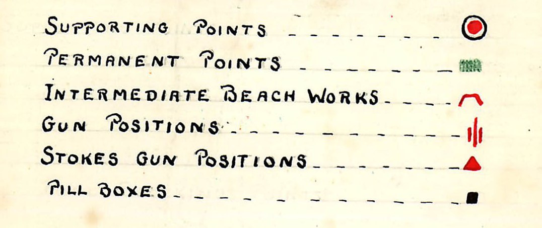
. Map key, (c) J Hall. as a JPG image")
|
Bacton Stokes Mortar Position, site of Stokes Gun Position according to a military map of First World War defences in North Norfolk (Coast Road, Bacton, North Norfolk, Norfolk). Map key, (c) J Hall. (File name: 8238_708.jpg) |
JPG | 81 Kb |
. Map, (c) J Hall. as a JPG image")
|
Bacton Stokes Mortar Position, site of Stokes Gun Position according to a military map of First World War defences in North Norfolk (Coast Road, Bacton, North Norfolk, Norfolk). Map, (c) J Hall. (File name: 8238_707.jpg) |
JPG | 51 Kb |
