
North Yorkshire, York and Lower Tees Valley Historic Landscape Characterisation (HLC)
Melanie Dalton, Peter Rowe, Steve Toase, 2013. https://doi.org/10.5284/1022583. How to cite using this DOI
Data copyright © Historic England, North Yorkshire County Council, City of York Council, North York Moors National Park Authority, Yorkshire Dales National Park Authority, Tees Archaeology unless otherwise stated
This work is licensed under the ADS Terms of Use and Access.

Primary contact
Gail
Falkingham
Historic Environment Team Leader
Waste and Countryside Services, Business and Environmental Services
North Yorkshire County Council
County Hall
Northallerton
North Yorkshire
DL7 8AH
England
Resource identifiers
- ADS Collection: 1634
- DOI:https://doi.org/10.5284/1022583
- How to cite using this DOI


Overview
The specific aims of the project were:
- To characterise the present landscape of North Yorkshire and Lower Tees Valley, in terms of the visible evidence of the human processes that formed it.
- To improve and promote the understanding and appreciation of the historic environment of North Yorkshire and the Lower Tees Valley, both locally and regionally, to a variety of users.
- To create a body of data and a tool to enable informed decisions to be undertaken on conservation and future development.
- To assist partnership with other agencies, particularly with regard to targeting of agri-environment schemes and schemes for rural diversification.
- To inform and generate research agendas for the historic environment.
Project Outputs:
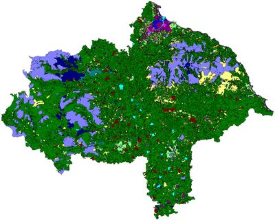
The GIS mapping and digital database are the main products of the project, which consist of a GIS map layer covering all of North Yorkshire including the North York Moors and Yorkshire Dales National Parks, the City of York and the Lower Tees Valley, made up of thousands of polygons defining areas of specific historic character. Each polygon links to a record within the database which holds information on the current landscape of that area and on any previous landscape characters that have been identified.
A final report summarises details about the project and its methodology and gives an overview of the historic landscape character types. There are also overviews of the characterisation results for each of the project partner areas, as well as examples of how the data may be analysed at national character level, as well as parish and estate level. There is also a section outlining potential for future research.
There is also a technical user guide, which includes additional details about the project methodology and terminology.
The HLC dataset is also available via the North Yorkshire County Council Historic Landscape Characterisation website.
