
Retreat Farm Quarry, Grimley, Worcestershire
Worcestershire Historic Environment and Archaeology Service, 2007. https://doi.org/10.5284/1000015. How to cite using this DOI
Data copyright © Worcestershire Historic Environment and Archaeology Service unless otherwise stated
This work is licensed under the ADS Terms of Use and Access.


Primary contact
Robin
Jackson
Project manager
Worcestershire Historic Environment and Archaeology Service
Woodbury
Worcester University
Henwick Grove, Worcester
WR2 6AJ
England
Tel: 01905 855401
Resource identifiers
- ADS Collection: 754
- ALSF Project Number: 3371
- DOI:https://doi.org/10.5284/1000015
- How to cite using this DOI

Introduction
The Project at Retreat Farm Quarry, Grimley, Worcestershire was undertaken by Worcestershire Historic Environment and Archaeology Service (WHEAS) and commissioned by English Heritage through the Aggregates Levy Sustainability Fund.
The project comprised a staged programme of archaeological investigation undertaken in response to an ongoing programme of mineral extraction by Tarmac Limited. The site was subject to a pre-PPG 16 planning permission and the project aim was to assess the impact of quarrying upon archaeological remains, and inform proposals for subsequent stages of mitigation within yet to be quarried areas.
The first stage comprised collation and assessment of existing documentary and aerial photographic evidence from within a study area centred on the permitted quarry. This covered approximately 406 ha and encompassed four scheduled sites and the village of Grimley.
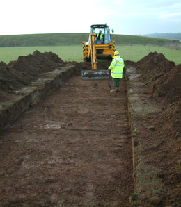
Mapping of an extensive cropmark complex crossing the study area revealed a series of multi-period cut features, representing a diverse range of landscape use including occupation, cultivation and funerary activity. These extended into the permitted area quarry but unfortunately, by the end of Stage 1, quarrying had already removed much of the surviving complex except one limited area of cropmarks indicative of small pits. A second stage of fieldwork, comprising geophysical survey, appeared to confirm the presence of these features, leading to targeted evaluation trenching of this surviving fragment of the site. These were, however, revealed to be irregular, amorphous hollows and probably can be related to orchards or hopyards which are common locally. No further works were recommended.
Since much of the area has now been quarried away, the mapping and analysis of this multi-phase cropmark complex along the western banks of the River Severn provides the sole record for many sites within a wider cropmark complex.
