Tim Evans
In June 2013 I wrote the first in what I planned to be a two part blog describing my work on the Rural Settlement of Roman Britain Project (henceforth RRS). A little later than planned, here it is.
Background
The RRS project arose from a two-stage pilot project undertaken by Cotswold Archaeology and funded by English Heritage (now Historic England), Assessing The Research Potential of Grey Literature in the study of Roman England. This project identified the large levels of grey literature, the colloquial term for unpublished reports produced primarily through the planning process containing significant information about the Roman period.
The RRS project is being undertaken by the University of Reading and Cotswold Archaeology and funded by a grant from the Leverhulme Trust with additional backing from Historic England. The project has built on the pilot by reviewing all sources – traditional published journals/monographs and grey literature – for the excavated evidence for the rural settlement of Roman Britain with the over-arching aim to inform a comprehensive reassessment of the countryside of Roman Britain.
Phase 1 (April 2015) publishes the settlement evidence from Roman England. Subsequent phases will add Roman Wales (by December 2015) and the related finds, environmental and burial data (by 1st April 2017). These will be used alongside the specific site data in a series of integrative studies on rural settlement, economy, people and ritual to be published by the Society for the Promotion of Roman Studies as Britannia Monographs between 2016 and 2018.
Methodology
Given the levels of grey literature previously identified, a large part of the project was obtaining access to these files, primarily through the relevant Historic Environment Record (HER). Once identified, and if not already in digital form the report was scanned, and all reports passed over to the researchers at Reading. Whilst this was going on, one of my roles was to look at the organisations that had written these reports and go about securing relevant permissions to archive and disseminate online via the ADS’ Library of Unpublished Fieldwork Reports. This task was made easier by the fact that most organisations had already signed a licence with us to disseminate their reports via OASIS, and it was a simple task to get in touch and ask if extra reports could be added in as an extension of this agreement. Unsurprisingly, there was an overwhelmingly positive response.
Slightly trickier were the reports written by organisations not using OASIS, or predating the system. In this case an element of detective work was required, scouring the web as well as the IFA (now CIFA) directories for contact details. Again, there was an overwhelmingly positive response, which I think goes to show the impact and perceived value of making fieldwork reports available online.
So, thanks must me given to all those who helped in this undertaking, especially the HERs who provided reports and exports from their systems. Quite simply the project couldn’t have progressed without them.
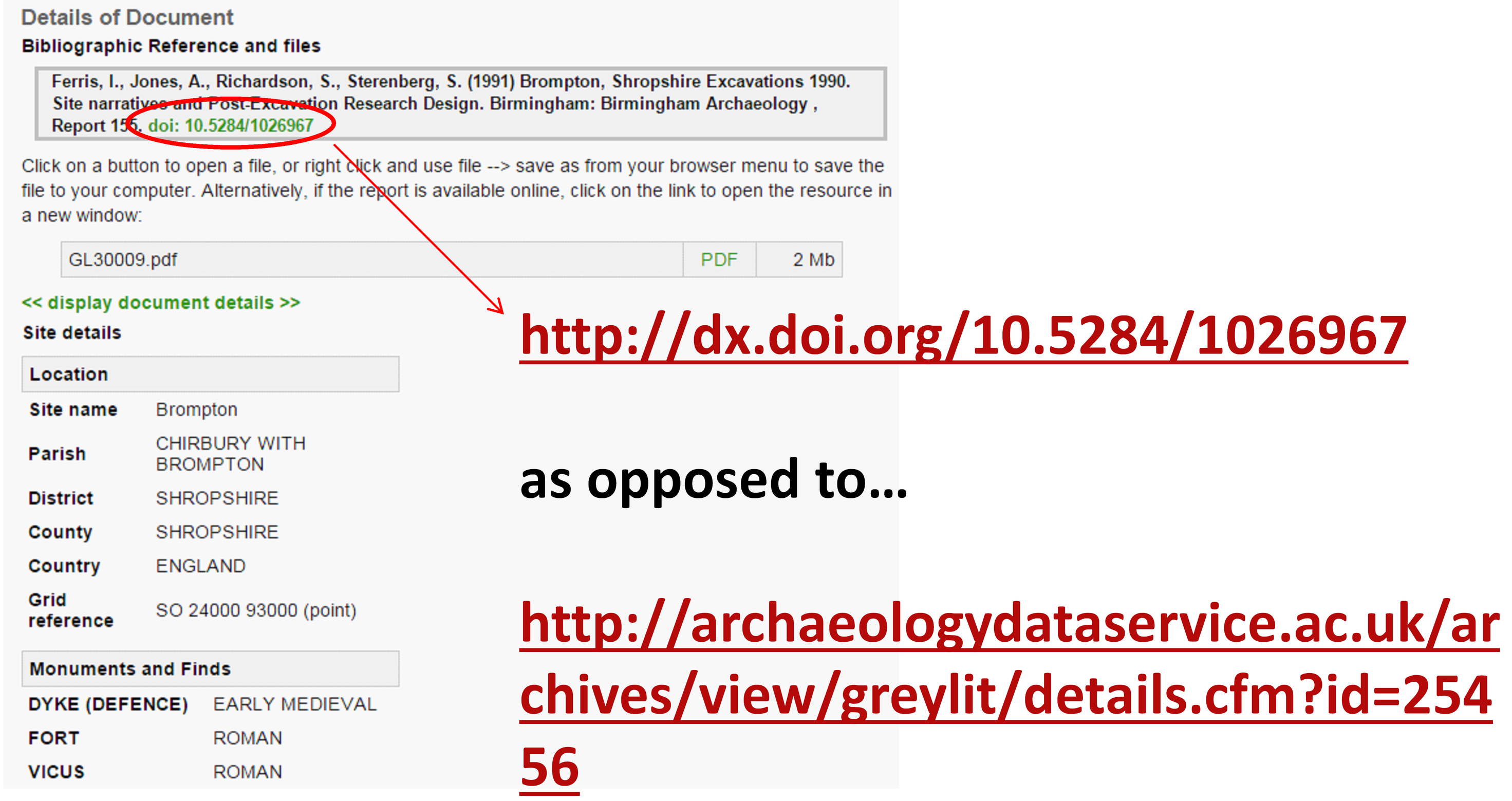
Reports were then passed to me, where they were OCR’d and converted into a suitable archival format. Metadata was then created using the Information Standards in Heritage (FISH) Thesauri, reports added to the library and finally, a DOI created for citation purposes. As demonstrated below, this provides a consistent, reliable and authoritative method of citing these reports.
Grey Reports
In total 1898 reports were added to the library, in addition to 557 that were already online via OASIS. It should be stated that this number was just that which included excavated evidence, including a small number of non-intrusive investigations such as geophysical surveys which produced plans that assisted subsequent interpretation. It should also be stated that not all of these reports were actually used (or I should say cited) by the RRS research team. In some cases this is as reports were subsequently found to not contain significant information (‘false positives’) or were interim statements or small post-excavation assessments that were subsequently surpassed by a publication. However, all reports were retained and disseminated for future reference by the community. As an aside, in the numbers of reports there’s some very interesting (to me at least) insights into reporting practices and the use of OASIS across the country. However I’ll save that for another blog post.
As a corpus, these reports represent a fascinating snapshot of fieldwork reporting over 30 years, and it’s interesting to compare the reporting styles and conventions of, for example:
- A watching brief (and excavation) from 1984 doi: 10.5284/1023763
- An excavation report from 2014: doi: 10.5284/1030479
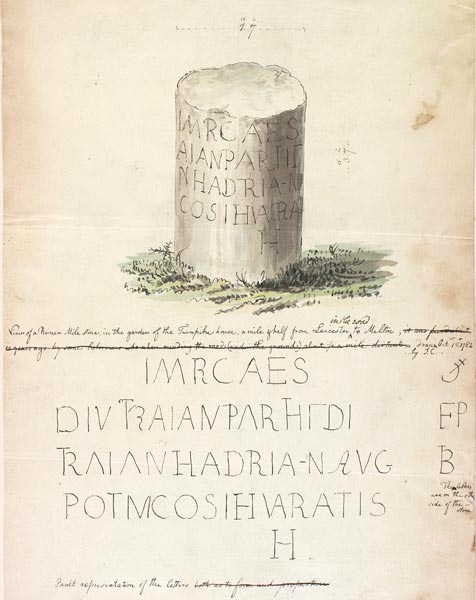
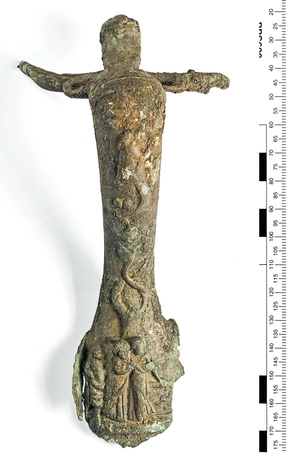
In-particular, the increased use of software in creating born-digital files allows far more information and images to be included in these reports, such as the Bronze jug handle from Creslow Manor Farm Buckinghamshire (below).
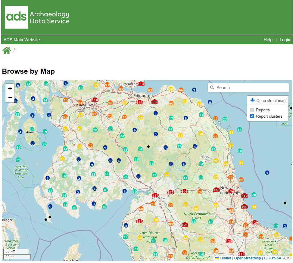
Creating the project interface
Once the reports were all in the library, my next task was to create an interface that allowed the project database to be queried. I settled on two parts, a traditional database form builder, and some Web mapping. The interface was released in early April 2015 and can be found here: doi:10.5284/1030449
This database is incredibly detailed, recording both site type and the features within. It also includes details on the type of investigation (including organisation) and the sources consulted. The database can thus be searched as a standard ‘show me all the sites of type x‘ query, but also ‘show me all the sites of type x where the source is grey literature‘. This type of detail can hopefully allow some interesting meta-studies to be carried out, allowing users to focus purely on grey literature, or to compare reporting practices for types of sites or regions. Something I also added in here was external identifiers, something that admittedly I started to become fixated by. To explain, alot of data came with HER ids (event, source, monument), for OASIS reports there were also things like museum accession id, OASIS id, Site ID etc etc. The museum accession id was raised as an important piece of information at the West Midlands Regional Seminar (where interim progress was reported back to local units, HERs etc), as significant bones assemblages from the region had not been reported. Hopefully, by providing this information it may spur researchers (PhD students of the future?) into identifying such backlogs, and consulting the physical archives.
I started compiling these on a ‘best efforts’ basis, and have incorporated some of them into the search options. It’s not comprehensive, and hopefully I’ll be able to add some extra details and functionality in with the Phase 2 update (see below). But to show an example:
- Query ‘Gloucestershire’ and ‘Recorded HER Identifier’ returns 134 results
- Click on the results for Totterdown Lane, Horcott and you’ll see that it covers two HER monuments: 15370 and 21693
Alternatively, if you already knew a Monument ID you could enter 21693 in the HER Monument ID field and see if it has been referenced. As stated, this isn’t comprehensive and does have gaps based on the information (and time) available. It is however something to build upon.
For the results page I decided to present records spatially. At first this was just using a standard OpenStreetMap / Google Maps backdrop. However, I soon discovered the an excellent set of map tiles created by Johan Åhlfeldt as part of his work creating a digital atlas of the Roman Empire The tiles are free to use under a CC-BY licence and, quite honestly, have been a god-send in providing some context for results.
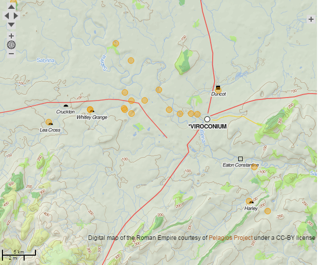
The usual backdrops are also there, as well as data from the Ordnance Survey and NRHE (via our own holdings in Archsearch) for those who’d prefer alternative views.
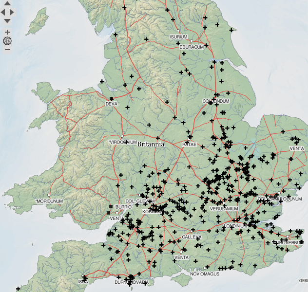
The dots on maps then take you to a record page based on the database entry, this includes description and classifications used, but also all sources consulted which – if they’re online – includes the link. Below is an example of Alconbury Hill in Cambridgeshire with a link to its grey literature, an overview of the plan of the site and its external identifiers.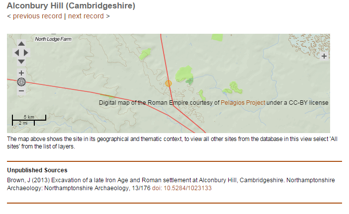
The Map
As well as the form builder, I was also requested to build an online atlas. I’d done quite a few of these before on other projects, notably the original pilot. Previously I’d been using various ESRI web servers such as ArcIMS (Arc Internet Map Server), however in recent years the ADS have been looking at alternatives such as OpenLayers (OL) (which we use for display of Archsearch results). This was the perfect opportunity to look more closely at OL, but also Geoserver, an open source server for spatial data.
Working with these tools was great fun, in-particular Geoserver has proved an intuitive and simple to use system for hosting spatial data. Little things like being able to cache tiles (enabling smoother performance) and customization of datasets using an implementation of XML has saved time, and I think enabled the creation of a useful map interface:
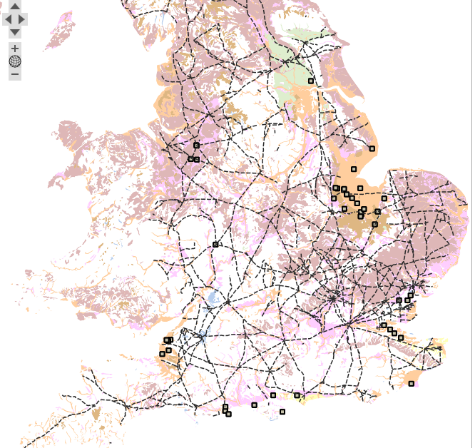

The dataset is broken down into major site types, allowing you to compare distributions against for example geology, road networks and terrain. There’s also the option to filter results by date, so for example comparing recorded sites at ADS 200 and AD 400 in the Yorkshire region there is a demonstrable decrease in coverage
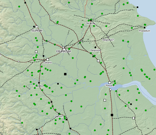
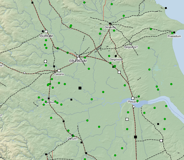
Farms in use at AD200 (left) and AD400 (right).
As with the database, each record will take you through to the full dataset. I’ve personally spent hours exploring the map and it stands as a rich and detailed record of the excavated resource.
Final thoughts and plans for subsequent phases
The interface was officially launched at the project research conference at the University of Reading on 14th April. Somewhat bravely/foolishly (delete as applicable) I went for a live demonstration in front of 200 of the great and good of UK archaeology. Fortunately all went well and I can see from the stats pages that people are using the interface in large numbers, and with individual users spending hours trawling through records. I must offer my thanks to Mike Fulford, Alex Smith and the rest of the team at Reading and Cotswold for the faith placed in me to deliver this on time. It was alot of work but ultimately great fun to work on, and its pleasing to see people re-using the data in such large numbers.
We’re not done yet though! Settlement data from Wales is due to be added in by December 2015. This will add c.100+ records into the current dataset (both database and map). If time permits, I’ll also be adding in a few more sets of HER identifiers and functionality for searching these. I’ll also look at switching the map interface over from OL2 to OL3. The latter was released towards the end of my initial map work, however it includes a number of features that I’d like to add into the RRS interface. My colleague Jenny O’Brien has already incorporated OL3 into her excellent work creating an interface for the Ipswich backlog project , so I’m hoping to get inspiration from there.
One response to “Rural Settlement of Roman Britain”