
Defence of Britain Archive
Council for British Archaeology, 2002. (updated 2006) https://doi.org/10.5284/1000327. How to cite using this DOI
Data copyright © Council for British Archaeology unless otherwise stated
This work is licensed under the ADS Terms of Use and Access.

Primary contact
Council for British Archaeology
92 Micklegate
York
YO1 6JX
England
Tel: +44 (0)1904
Fax: 671417
Resource identifiers
- ADS Collection: 324
- DOI:https://doi.org/10.5284/1000327
- How to cite using this DOI
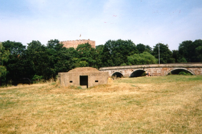
Type 24, thin-walled pillbox.
(Source: Field Visit )
Hexagonal pillbox defending Lady Bridge.
(Source: Field Visit 1996)
Pillbox, concrete-faced, sunk partly into ground, and with some top earth cover remaining [camouflage]. Entrance is only 49ins high, so there is probably about 2ft below ground. Water-logged. Internal anti-ricochet wall. Sides 60ins long. Entrance, 28ins wide. Overlooked by medieval castle to NE.
(Source: Field Visit 2000/08/24)
| Type of site | PILLBOX (TYPE FW3/24) |
|---|---|
| Location | Tamworth, in parkland just to SW of Lady Bridge at junction of River Tame with the Flood Relief Channel. |
| Area |
Tamworth, Staffordshire, England |
| Grid reference |
SK 2046 0379
(Scale: 1:25000
, 2000)
|
| Period | WW2 |
| Condition | Good |
| Materials | Reinforced Concrete |
| Threats |
Type: Flooding (Medium Term) Detail: Site of pillbox is waterlogged. |
| Recorder | Regan, A. J. (Pillbox Study Group) |
| Defence grouping |
Western Command Stop Line No 6 - Tamworth via Trent Valley, E side of Stoke-on-Trent, to Macclesfield and Stockport, thence to 6 miles SE of Manchester. Western Command Stop Line No 5 - Tamworth to Burton-on-Trent and thence by River Dove to Ashbourne |
| Photographs |

(3) - site and exterior views (2 DIGITISED). |
| DOB site reference: | S0005332 |
| Associated Identifier | Staffordshire SMR (ref: 05032) |
| Event |
Construction, In the period 1940 1941 Field Visit, On 2000/08/24 Field Visit, During 1996 |
