
Defence of Britain Archive
Council for British Archaeology, 2002. (updated 2006) https://doi.org/10.5284/1000327. How to cite using this DOI
Data copyright © Council for British Archaeology unless otherwise stated
This work is licensed under the ADS Terms of Use and Access.

Primary contact
Council for British Archaeology
92 Micklegate
York
YO1 6JX
England
Tel: +44 (0)1904
Fax: 671417
Resource identifiers
- ADS Collection: 324
- DOI:https://doi.org/10.5284/1000327
- How to cite using this DOI
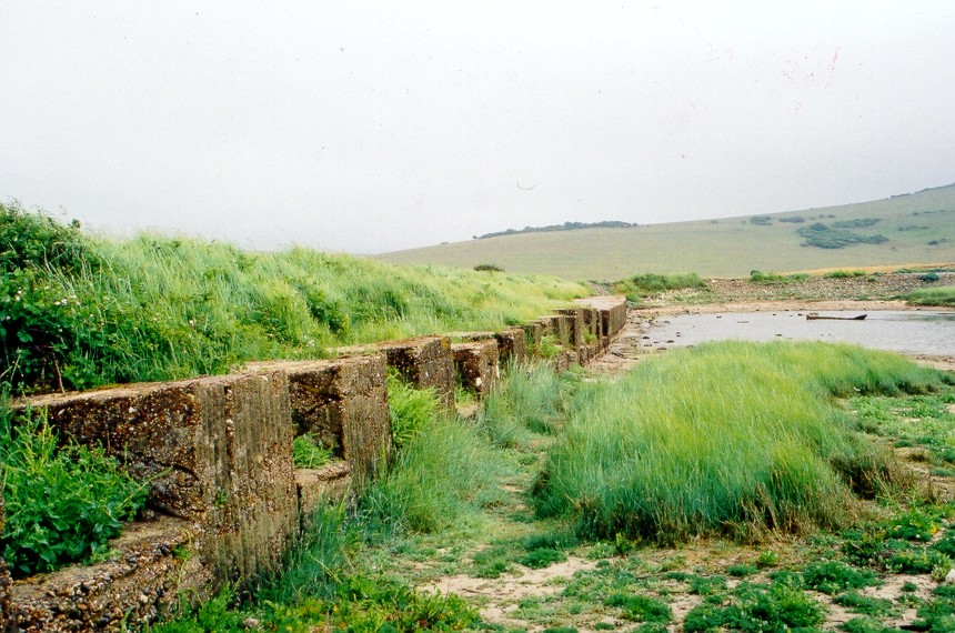
Anti-tank blocks and anti-tank wall running E - W across Cuckmere Valley. 17 blocks and anti-tank wall.
with PLAN drawn on form.
(Source: Field Visit 1997/11/09)
Line of massive anti-tank cubes (corrugated-iron shuttered) on concrete base. There are 18 x blocks, the end two of which turn at right angles to head towards the sea. Each block is 6ft-7ft long and 4ft-5ft high from its concrete base. Towards the E, the line is continued by a solid anti-tank wall [see UORN 8610], which itself was continued at a sharp angle to the edge of the river by further blocks (and two blockhouses - see UORNs 13678 and 13709) now destroyed.
[See also UORN 14830].
(Source: Field Visit 2001/06/28)
Line of anti-tank cubes, making angle as it approaches the river [seen on wartime and post war APs - 16 cubes can be counted at the W end of the line]. Most had disappeared by 1977.
(Source: Air Photograph 1940)
APs (German and British) show a double line of anti-tank blocks running to the E of the Cable House towards the shore.
(Source: Air Photograph 1942)
| Type of site | CUBE |
|---|---|
| Location | W of Cuckmere Haven, nr. River Cuckmere and the Cable House. |
| Area |
Seaford, Sussex, East, England |
| Grid reference |
TV 51509 97774
TV 51467 97750 (Scale: 1:10000 , 1990) |
| Period | WW2 |
| Condition | Good |
| Materials | Concrete |
| Recorder | Farthing, Geoff (Pillbox Study Group) |
| Defence grouping |
Sussex coast defences - Defences of the East and West Sussex coastlines, and their immediate hinterland. Sussex coast defences (Cuckmere Haven) - Fortifications protecting the coastal valley of the River Cuckmere, East Sussex. |
| Photographs |

(1) - site view. |
| Adjacent sites | Non-standard pillbox to NW at TV 514978. |
| DOB site reference: | S0008609 |
| Reference |
1940/10/23 Taktisches Luftbildbuch Nr.3 |
| Event |
Construction, In the period 1940 1941 Field Visit, On 1997/11/09 Field Visit, On 2001/06/28 |
