
England's Historic Seascapes: Scarborough to Hartlepool
Cornwall Council, 2007. https://doi.org/10.5284/1000201. How to cite using this DOI
Data copyright © Historic England unless otherwise stated
This work is licensed under the ADS Terms of Use and Access.


Primary contact
Charlie
Johns
Cornwall Council
Kennall Building, Old County Hall
Station Road
Truro
TR1 3AY
UK
Tel: 01872 322056
Resource identifiers
- ADS Collection: 744
- ALSF Project Number: 4731
- DOI:https://doi.org/10.5284/1000201
- How to cite using this DOI
Introduction | Seascapes Character Types
Cliff
- Introduction: defining/distinguishing attributes and principal locations
- Historical processes; components, features and variability
- Values and perceptions
- Research, amenity and education
- Condition & forces for change
- Rarity and vulnerability
- Sources
Introduction: defining/distinguishing attributes and principal locations
The Type Cliff includes the following sub-types:
- Bare cliffs;
- Precipitous vegetated cliffs.
Typical components of this Type include:
- military defences (eg pillboxes, anti-tank cubes, signal stations, fortifications, radar stations);
- maritime safety services (eg coastguard lookouts);
- navigation aids (eg lighthouses, fog stations, landmarks);
- industrial extraction and processing sites (e.g. quarries, mines, lime kilns, railway tunnels).
Historical processes; components, features and variability
The cliffs along this stretch of coast provide some outstanding exposures and breathtaking scenery. They are formed of sedimentary rocks laid down in the Tethyen ocean of the Jurassic and Cretaceous periods with a capping of glacial tills from the Ice Age. From this manner of formation the rocks are stratified, and are composed chiefly of shales, sandstones and limestones, with iron mineral spread generously through the whole (Owen 1986, 2).
Cliff-tops have been utilised since prehistory, as areas of summer grazing, sources of fuel, military lookouts and as navigational aids. These agricultural, domestic, military and navigational uses continued through the medieval and post-medieval periods and into the first decades of the 20th century.
Looking out from cliff-tops to the sea have been, from at least the 16th century, generations of military men, coastguards (and excise men or smugglers), and fishermen. Military sites found on cliff-tops include look-outs, pill-boxes, batteries, radar stations, castles and forts. There are also coastguard look-outs and lighthouses. The cliffs at Scarborough are dominated by Castle Hill, a cliff promontory rising to nearly 100m above sea level upon which Scarborough Castle is situated, as well as a former site of a Roman signal station (Figure 9.47). Roman signal stations were also sited at other cliff-top locations along this coast, at Kettleness, Goldborough, Ravenscar and at Huntcliff and purportedly at Whitby.
.jpg)
Figure 9.47. Aerial view of the remains of the Roman signal station at Scarborough Castle
(© English Heritage/Skyscan)
There is a long tradition of religious houses being located on remote coastlines, and this coastline is no exception with the remains of Whitby Abbey situated high up on the cliff-top overlooking Whitby town (Figure 9.48) and St Hilda's Church located on the Heugh headland at Hartlepool. This is primarily due to the fact that monasteries were closely involved with exploiting marine resources and foreign trade.
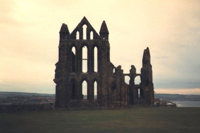
Figure 9.48. Whitby Abbey (© Dave Hooley)
From the crumbling shale cliffs of Staithes to the 200m (660 feet) high cliffs at Boulby (the highest vertical cliffs in England), the cliffs can be seen to exhibit a wide variety of rock types and coastal features associated with them. To the south east of Saltburn the coast changes rapidly from the low-lying cliffs and sand dunes at Hartlepool and Tees Mouth to high irregular cliffs, cleft at intervals by narrow defiles and small valleys. From Staithes to Port Mulgrave these give way to the shales and ironstones of the Cleveland Ironstone Formation, with the ironstone being of economic importance and extensively mined. All these rocks contain abundant fossils such as ammonites, especially the ironstones and alum shales. Of further economic importance, especially in the Victorian times, is the Jet Rock in the cliffs at Port Mulgrave, Sandsend and Saltwick Bay where the shale rocks of the Upper Lias are exposed along the cliffs and also contain many fossils.
From at least the 17th century the shale in these cliffs was worked for alum as can be seen at Sandsend, Boulby, Loftus, Peak, Stoup Brow, Saltwick Bay and Kettleness. The upper part of the alum shales was exploited to make cement and so are called the Cement Shales.
Around the turn of the 19th century, learned societies devoted to natural history, science, literature and philosophy were springing up all over Britain. It was also a time when the new science of geology was becoming a popular subject, new theories were being propounded and spectacular finds were being made. Amongst these discoveries were large skeletons of fossil marine reptiles found along the Yorkshire coast largely as a result of excavating industrial quantities of alum shale. The first reptile to be reported from the area was a marine crocodile. The Gentleman's Magazine of 1759 was given a description of the 'Skeleton of an Allegator found in the Allom Rock near Whitby, January 3, 1758'. It was discovered by Captain William Chapman (Osborne 1998, 29).
A poster advertising the exhibition of a Plesiosaur fossil found near Whitby in 1841 read:
'A splendid and very valuable fossil '"Pleiosaurus Dolochodeirus" recently found Whitby Cliffs. This unparalleled organic specimen of so extraordinary an animal measures 15 feet in length, and 8 feet 5 inches across the fore paddles. The neck is 6 feet 6 inches long, exclusive of the head.
Among the multiplicity of fossil petrifications discovered in the neighbourhood of Whitby, this by far surpasses all, even the famed crocodile in the Whitby Museum; indeed it is questioned whether any fossil remains were ever discovered equal to that of this wonderful species of the Plesiosaurus tribe...' (Osborne 1998, 180).
The alum quarrymen uncovering these large skeletons sold them as curiosities to other parts of Britain. Certain citizens of Whitby, under the Rev George Young, became concerned that whilst these curiosities were being found locally they were being lost to Whitby and this concern spurred them on to form the Whitby Literary and Philosophical Society in 1823 with the prime purpose to set up a Museum.
The alum quarries have significantly altered the cliffs, in some places beyond former recognition, and as a result in places, they are often unstable and prone to collapse (Figures 9.49 & 9.50). Natural erosive forces are also responsible for the discovery of many prehistoric and Roman remains, exposed as a result of these falls. For example a hoard of Bronze Age socketed axes was found scattered on the beach at Scalby Ness after a cliff fall in 1916 and a Neolithic stone axe was found in the Scarborough Castle Dykes in 1950. Flint scatters have also been found along the cliff-tops here, for example at Hart Warren just north of Hartlepool.
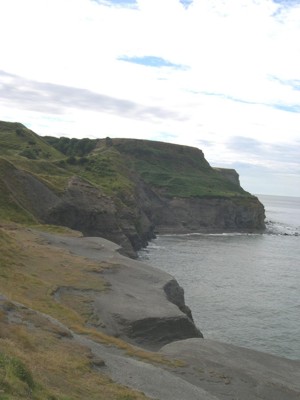
Figure 9.49. Cliffs altered by alum quarrying at Sandsend
Cliff erosion also takes place along small faults and joints, often forming small caves, some of which were probably utilised for the smuggling notorious along this stretch of coast in the 18th and early 19th centuries.
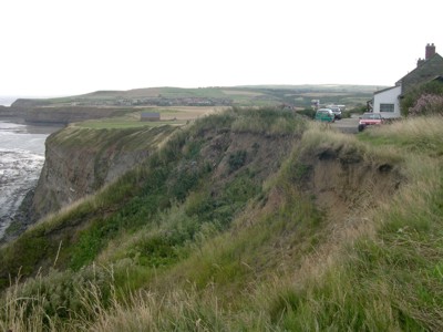
Figure 9.50. Cliff erosion at Boulby
The generally accepted theory that the cliffs along this stretch of coast have eroded up to three miles in some places, based on the assumption that cliffs erode at an average rate approximately 30ft per century or 10cm per year (Agar 1960, 409-428), has recently been challenged by Cleveland Potash Ltd. Their research with Durham University (Department of Geography) has been looking at coastal processes at what is arguably a higher resolution than elsewhere in the UK or beyond, taking advantage of newly available monitoring technology. The work includes the historic and contemporary land-surface deformation, the development of a subsidence model for predictive use, the scale and extent of historical activity, and cliff development, evolution and recession. This research has identified rates of cliff retreat an order of magnitude lower than previous estimates, with relatively ancient cliffs remaining in similar positions in the post glacial period. Work is continuing developing this research agenda with efforts being made to identify underlying mechanisms for cliff erosion, and extending contemporary monitoring data to the long term evolution of the coastline (David Pybus pers comm).
Values and Perceptions
Much visited, mainly via the Cleveland Way coastal path, and much loved. Most people would probably be surprised to learn how much human activity took place on these cliffs up to the early 20th century. As the boundary between the sea and the land cliffs have considerable psychological and mythic meaning and value for many people. Buildings and structures relating to watching the sea (e.g. lighthouses, military installations) dot the cliff-line and observant visitors will always be able to see some historic features, even on the wildest, most windswept stretch.
The rocks outcropping along these cliffs have long provided a fertile stamping ground for successive generations of geologists and fossil collectors. The interesting rock outcrops here and the spectacular fossils contained within them were the basis of many theories propositioned by the likes of James Hutton ('the father of modern geology') and William Smith and George Young. In this respect the cliffs here may be considered of significant value in terms of their contribution to the development of modern geology.
A local legend goes that when St Hilda first came to Whitby, then just a collection of fishing huts, she found the place infested with snakes. Such was her power that, with a wave of her hand, she turned them all to stone. This myth no doubt grew from the great quantity of fossil ammonite 'snakestones' that were found everywhere in the rocks of the cliffs and on the beaches around Whitby. They were so abundant that the town put them on its coat of arms (Osborne 1998, 296).
Research, amenity and education
In addition to their pioneering work on cliff development, evolution and recession, Durham University and Cleveland Potash have also mapped detailed extents of massive coastal landslides from Saltburn to Whitby. Instabilities as a result of the Alum works are suggested to have caused most of the recent landslides. Present day processes have been monitored using high resolution terrestrial laser scanning and digital photogrammetry. These high resolution techniques have identified 0.5 million individual rock fall events to date. The research is now analysing the nature of this rock fall activity in order to create a predictive model for analysing scenarios of future change. So far it appears that no one particular environmental control dominates coastal erosion, with a significant degree of preparation required in order for large changes to the coastline to be induced. The Failure Erosion Model in development attempts to identify these thresholds with respect to future anticipated changes (David Pybus pers comm).
Archaeological and historical research has also been carried out on alum, jet, ironstone and other industries that took place in this Type, as well as on the Roman signal stations, prehistoric flints, smuggling/excise activities. The geological history of these cliffs has also been extensively researched.
In terms of amenity cliffs are frequently visited by walkers, climbers, etc, and there is potential here to enhance their understanding, appreciation and enjoyment of the heritage they encounter.
Condition & forces for change
There will continue to be gradual erosion by the sea and the more longer-term threat of sea-level rise. Human forces for change include the construction of sewerage schemes and coastal defences. As well as the construction itself, the movement of water and sediments can damage historical and archaeological remains.
Rarity and vulnerability
Much of this cliff line falls within Sites of Specific Scientific Interest (SSSIs), Special Protection Areas (SPAs), Special Areas of Conservation (SACs) and RAMSARs, as well as being designated as a Heritage Coast from Scarborough to Saltburn and as part of North York Moors National Park.
The late Roman signal stations at Huntcliff, Goldsborough, Ravenscar and Scarborough are celebrated cliff-top features of this north east coast, but some are being eroded away. Part of the signal station at Scarborough has been lost through cliff erosion. As sites become more dangerous they are made less accessible to the public.
Recommendations
This Types importance lies in its research and amenity potential and in its high value for local people.
The potential existence of buried archaeological features within cliffs should be considered when dealing with cliff falls and proposed developments.
Careful maintenance of extant features should be encouraged and, if they are protected, statutory constraints should be enforced. The active recording of features and thus their preservation should also be promoted as this is more sustainable manner than building and maintaining sea walls, etc, to prevent their loss (David Pybus Pers Comm).
More research into this Type is required and good management will be made easier through the production and implementation of integrated management plans.
Both natural and historical interests should be fully considered. As well as protecting vulnerable but important remains, plans should aim to improve the interpretation of this Type and thus increase public enjoyment of it.
With regards to Roman signal stations, English Heritage have highlighted a number of considerations involved in managing these sites, including coastal defence, transport, tourism, agriculture, public and private property interests and ecology, as well as the archaeological value of the monument itself (Fulford et al 1997, 179).
Sources
Publications:
Agar R 1960. Post-Glacial erosion of the North Yorkshire coast from the Tees estuary to Ravenscar. Proceedings of the Yorkshire Geological Society 32, 409-428.
British Regional Geology, 2000. Eastern England from the Tees to the Wash. 2nd Ed. Institute of Geological Sciences
Fulford, N, Champion, T and Long, A (eds), 1997. England's Costal Heritage: a survey for English Heritage and the RCHME. RCHME and English Heritage Report 15
Herring P, 1998. Cornwall's Historic Landscape. Cornwall Archaeological Unit, Truro
Lewis, D B (ed), 1991. The Yorkshire Coast.
Osborne, R, 1998. The Floating Egg. Episodes in the Making of Geology
Owen, J.S, 1986. Cleveland Ironstone Mining
Rawson, P F and Wright, J K, 2000. The Yorkshire Coast
Websites:
http://www.fortunecity.com/greenfield/ecolodge/25/scarborough.htm
http://www.whitbymuseum.org.uk/d12/foss/index.htm
