
England's Historic Seascapes: Scarborough to Hartlepool
Cornwall Council, 2007. https://doi.org/10.5284/1000201. How to cite using this DOI
Data copyright © Historic England unless otherwise stated
This work is licensed under the ADS Terms of Use and Access.


Primary contact
Charlie
Johns
Cornwall Council
Kennall Building, Old County Hall
Station Road
Truro
TR1 3AY
UK
Tel: 01872 322056
Resource identifiers
- ADS Collection: 744
- ALSF Project Number: 4731
- DOI:https://doi.org/10.5284/1000201
- How to cite using this DOI
Introduction | Seascapes Character Types
Coastal Rough Ground
- Introduction: defining/distinguishing attributes and principal locations
- Historical processes; components, features and variability
- Values and perceptions
- Research, amenity and education
- Condition & forces for change
- Rarity and vulnerability
- Sources
Introduction: defining/distinguishing attributes and principal locations
The Type Coastal Rough Ground includes the following sub-types:
- Rough ground;
- Scrub.
Typical components include:
- military defences (eg pillboxes, anti-tank cubes, Roman signal stations, fortifications, radar stations);
- prehistoric and Roman sites, finds and field systems (flint scatters, barrows, coin hoards, settlements);
- maritime safety services (eg coastguard lookouts);
- navigation aids (eg lighthouses, fog stations, landmarks);
- industrial extraction and processing sites (eg quarries, mines, limekilns);
- Recreational facilities (eg caravan and chalet parks, golf links).
Coastal rough ground is defined as the unenclosed sloping ground beyond enclosed fields but above precipitous cliffs that runs along most stretches of the Yorkshire coast (Figure 9.56).
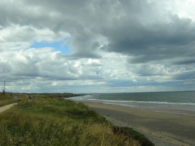
Figure 9.56. Coastal Rough Ground at Marske
The semi-natural habitats here are, to a considerable extent, the product of thousands of years of human activity, particularly summer grazing and extractive industry. Now almost entirely neglected; very little grazing. Long distance coastal footpaths run through the Type which is therefore quite busy in the summer months.
Historical processes; components, features and variability
The scrubby vegetation on most coastal rough ground has developed after several decades of neglect. Until its abandonment by farmers, vegetation would generally have been herb-rich rough grassland.
Archaeological sites are generally less varied than in upland rough ground as this has always been strictly marginal land.
Prehistoric components of this Type include flint scatters and ritual/ceremonial sites such as barrows.
Military sites are often found on this type, including look-outs, pill-boxes, batteries, radar stations and forts. There are maritime safety sites such as coastguard look-outs, daymarks and lighthouses.
Coastal rough ground would have previously been dependent on other neighbouring Historic Landscape Types, principally medieval and post-medieval enclosures. As summer grazing and fuel grounds, it formed an essential element of the mixed farming landscape.
Values and Perceptions
Much visited, mainly via the coastal paths, and much loved. Most people would probably be surprised to learn how much human activity took place on coastal rough ground up to the early 20th century (Herring, 1998). This is probably regarded rightly as one of the most 'natural' Types along the Yorkshire coast. As the boundary between the sea and the land, the coastal rough ground has considerable psychological and mythical meaning and value for historically-aware Yorkshire people.
It is from the buildings and structures found on coastal rough ground that relate to watching the sea (lighthouses, military installations, beacons etc) that the watchers would have passed messages along to neighbouring military installations, to neighbouring coastguards, excise men or to local seine fishing boat crews. Many of their sites survive and these flickering communications can be reconstructed in the minds of imaginative visitors.
Observant visitors will always be able to see some historic features, even on the wildest, most windswept stretch.
Research, amenity and education
Research and documentation of this Type is increasing. There are, however, long stretches for which historical documentation and research are still vague.
Survey, excavation and analysis of the well-preserved archaeological sites has already yielded valuable information and will continue to do so.
Potential for amenity and education is great. There are very few unspectacular Yorkshire coastlines. The semi-natural vegetation is itself of interest to many people, supporting insects, birds and mammals. Many people visit the more famous archaeological sites (eg Scarborough Castle) and could be encouraged, where safe, to visit more.
Many interest groups already make use of this Type: walkers, artists, writers, historians. There is great potential for further presentation of any coherent and well-preserved historical remains to the public.
Condition & forces for change
Survival is generally good as most coastal rough ground has been difficult to improve agriculturally but as this is increasingly neglected, many archaeological sites are becoming obscured by dense vegetation.
There are few forces for negative change beyond a minimal encroachment by farmers and an expansion onto certain cliffs of recreation facilities (eg caravan/chalet parks at Cayton Bay). Continued neglect of coastal rough ground for grazing will lead to the gradual submergence of less visible archaeological remains beneath a vegetation community which becomes annually less varied and more dominated by one or two vigorous species.
The use of coastal rough ground by long-distance walkers will continue to increase and so the place will become more widely valued; there are some problems of erosion but with careful management these can be contained.
Rarity and vulnerability
This Type is subject to numerous protective designations, such as SSSIs, SPAs, SACs and RAMSARs, as well as being part of the Heritage Coast that extends from Scarborough to Saltburn and of the North York Moors National Park.
This Type is of considerable importance. Its rare and well-preserved archaeological features survive in understandable complexes where time-depth is clearly visible. The Type is highly valued by both local people and visitors and has good potential for research and presentation.
Recommendations
Safeguarding this Type is potentially difficult because the neglect of cliff grazing has lasted for longer than most people's memories. The re-introduction of grazing may then be challenged as modern improvement of what is perceived to be natural landscape. Reintroducing cliff grazing should be encouraged, however, as this would facilitate the management of surviving historic and archaeological remains. Further loss of Coastal Rough Ground to agriculture (eg ploughing to cliff-edges), recreation and other development should be resisted.
The good maintenance of extant features should be encouraged and if they are protected statutory constraints should be enforced. More research into this Type is required and good management will be made easier through the production and implementation of integrated management plans. Both natural and historical interests should be fully considered. As well as protecting vulnerable but important remains, these plans should aim to improve the interpretation of this Type and thus increase public enjoyment of it.
Closely control further expansion of sea and river side settlements. Identify and secure key features.
Sources
Publications:
Herring P, 1998. Cornwall's Historic Landscape. Cornwall Archaeological Unit, Truro
Petts, D and Gerrard, C, 2006. Shared Visions: The North East Regional Research Framework for the Historic Environment. Durham County Council
