
England's Historic Seascapes: Scarborough to Hartlepool
Cornwall Council, 2007. https://doi.org/10.5284/1000201. How to cite using this DOI
Data copyright © Historic England unless otherwise stated
This work is licensed under the ADS Terms of Use and Access.


Primary contact
Charlie
Johns
Cornwall Council
Kennall Building, Old County Hall
Station Road
Truro
TR1 3AY
UK
Tel: 01872 322056
Resource identifiers
- ADS Collection: 744
- ALSF Project Number: 4731
- DOI:https://doi.org/10.5284/1000201
- How to cite using this DOI
Introduction | Seascapes Character Types
Dunes
- Introduction: defining/distinguishing attributes and principal locations
- Historical processes; components, features and variability
- Values and perceptions
- Research, amenity and education
- Condition & forces for change
- Rarity and vulnerability
- Sources
Introduction: defining/distinguishing attributes and principal locations
Components of the Type Dunes include:
- Military defence structures (anti-tank cubes, batteries, minefields, pillboxes, trenches and weapons pits);
- Recreation facilities (caravan and chalet parks, golf links);
- Ecclesiastical buildings (chapels, cemeteries).
Dunes are a localized habitat, principally located in the northern section of the study area, lining the River Tees and the coastal areas surrounding Teesmouth, at Marske-by-the-Sea, Redcar, Warrenby, Coatham, Seaton and West Hartlepool (Hart Warren).
Historical processes; components, features and variability
Dunes are areas of blown sand and shell deposits along low-lying stretches of shoreline. Locally they are sometimes called warrens (e.g. Hart Warren and Warrenby), presumably because of historical landuse (rabbits and other game). Marram grass holds together the seaward sides of dune complexes while more mixed plant communities and dune-pastures have developed on sheltered lees and lower dune-slopes. This apparently natural habitat has been influenced and affected by human activity, mainly through summer grazing of farm animals, and can be regarded as semi-natural. The marram grass itself has been introduced to some dunes to aid stability.
Within most of the dunes in this area are abandoned military structures, including anti-tank cubes, batteries, minefields, pillboxes, trenches and weapons pits. There is also the potential for important prehistoric and medieval features and complexes buried beneath Dunes.
The dunes themselves are post-glacial creations. An important historical feature of the development of dunes is the succession of sand movements and stabilizations; a stabilised land surface may be used for pasture, cultivation and settlement before being sealed by a further sand blow, the surface of which may in due course become stabilised and again used for pasture, cultivation and settlement.
In the second half of the 20th century, extensive caravan and chalet parks (eg Warrenby) and golf courses (eg Seaton Carew Golf Links) have been established on sand dunes in this area, considerably altering their character (Figure 9.51). People have been attracted by the long sandy beaches which edge most dunes since the later 19th century.
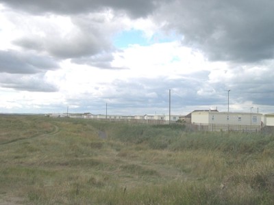
Figure 9.51. Cleveland golf links and caravan park
Ecclesiastical structures and features are also found in this type, for example the remains of St Sepulchre chapel at Warrenby and the old Hartlepool cemetery at Hart Warren.
Values and Perceptions
Most dunes are regarded as exciting wildernesses often tainted by modern caravan/chalet/golf course developments. Few people appreciate how the dunes fitted into local farming economies.
Research, amenity and education
Potential for research and documentation is reasonable. Archaeological sites possess considerable potential. Dunes are likely to contain well-preserved and well-stratified prehistoric and medieval settlements and fields and to have the best survival of bones, both animal and human. The study of dune formation and local environmental/climate history will be important as will the study of the more recent use made of dunes by local farming communities.
Potential for amenity and education research is good. Recreation has thus far used dunes mainly as adjuncts to desirable beaches or as bunker-filled golf courses but there is potential for encouraging the appreciation of the dunes themselves; their flora and some of the military and earlier sites within them.
Condition & forces for change
Sand dune systems are complex entities prone to instability and sudden, large-scale shifts. This may have important consequences for recognising, dating, and conserving archaeological sites in these areas (Petts and Gerrard 2006, 203).
The main threat to dunes appears to be from the expansion of recreation facilities. Most dunes are now fairly stable, thanks to the planting of marram grass. There is little likelihood of loss to agricultural expansion, road provision or housing.
Rarity and vulnerability
The dunes from Seaton Carew to Redcar are designated Sites of Special Scientific Interest (SSSIs), as well as being part of a Special Protected Area (SPA). North Gare Sands are also a National Nature Reserve (NNR).
Dunes are generally rich in buried archaeological remains. These are usually well-preserved, the dunes being non-acidic, and may date back to the Bronze Age or earlier. As such they are of the highest importance. Industrial and early recreation sites survive well. Dunes are themselves relatively rare formations, but the prehistoric and medieval features found within and beneath them and some of the industrial and military remains found on them may be very rare. Surviving features tend to be isolated and unrelated except when in industrial/recreational complexes.
Recommendations
Further research on the geomorphology of sand dunes should be a priority. Dune formation and destruction can be rapid; there is a need to ensure regular resurvey of dunes for archaeological remains, particularly after major storm events (Petts and Gerrard 2006, 203).
Excavations may reveal earlier phases and sand blows expose sections showing layers of old land surfaces interspersed with layers of sand; vividly demonstrating time-depth.
Historical and archaeological sites can be more closely studied and carefully presented as a means of raising awareness of the historical element of what is often perceived to be a natural environment.
The combined ecological and historical value of dunes should be borne in mind when considering expansion of recreation sites or the developments and presumptions should be made in favour of conserving these important places. The continued monitoring of dunes is important.
Petts and Gerrard (2006) recommend that 'a regression map showing changing patterns of sand dune distribution, based on Ordnance Survey maps and aerial photographs, should be constructed. This may indicate areas of rapid change and significant stability and should be supplemented by a campaign of coring and palaeo-environmental investigation' (Petts and Gerrard 2006, 203).
Sources
Publications:
Herring P, 1998. Cornwall's Historic Landscape. Cornwall Archaeological Unit, Truro
Petts, D and Gerrard, C, 2006. Shared Visions: The North East Regional Research Framework for the Historic Environment. Durham County Council
