
England's Historic Seascapes: Scarborough to Hartlepool
Cornwall Council, 2007. https://doi.org/10.5284/1000201. How to cite using this DOI
Data copyright © Historic England unless otherwise stated
This work is licensed under the ADS Terms of Use and Access.


Primary contact
Charlie
Johns
Cornwall Council
Kennall Building, Old County Hall
Station Road
Truro
TR1 3AY
UK
Tel: 01872 322056
Resource identifiers
- ADS Collection: 744
- ALSF Project Number: 4731
- DOI:https://doi.org/10.5284/1000201
- How to cite using this DOI
Introduction | Seascapes Character Types
Energy Industry
- Introduction: defining/distinguishing attributes and principal locations
- Historical processes; components, features and variability
- Values and perceptions
- Research, amenity and education
- Condition & forces for change
- Rarity and vulnerability
- Sources
Introduction: defining/distinguishing attributes and principal locations
The Type Energy Industry includes the following sub-types:
- Oil refineries;
- Gas refineries;
- Power stations;
- Renewable energy installations.
Within this study area the Type energy industry tends to be confined to the region in and around Teesside.
Oil and gas refineries at Greatham, Seal Sands, Port Clarence and Tees Dock are sprawling industrial complexes with extensive piping running throughout, carrying streams of fluids or gas between large chemical processing units. Oil is refined into more useful petroleum products, such as gasoline, diesel fuel, asphalt base, heating oil, kerosene, and liquefied petroleum gas. Gas is stored, canistered or piped onwards to provide heating, lighting and energy for both homes and industry.
One nuclear power station operates in the area, Teesside Power Station, at the mouth of the Tees estuary near Hartlepool.
Historical processes; components, features and variability
Typical historical components include:
- large, sprawling industrial complexes (including extensive piping, storage units, etc);
- cooling towers, chimneys;
- distribution depots and customer service centres;
- associated transport systems (such as railways, roads, ships, docks and tanker terminals).
The North Sea oil and gas industry has become a major economic activity since the late 1960s. The north east coast plays an important role in providing infrastructural support and there are a number of oil and gas installations on the North East coast, including terminals, storage facilities, refineries and tanker terminals. This is partly responsible for the relatively high shipping densities in the surrounding coastal waters (DTI, 2002).
These installations tend to have been built on large tracts of reclaimed land along the River Tees. The first attempt at land reclamation on the Tees was carried out early in the 18th century, when some embankments were built to protect Coatham Marshes from the sea. Considerable tracts of land were also reclaimed at Mandale and Jenny's Mill island, by the Tees Navigation Company, early in the 19th century (Le Guillou 1975, 48). The largest areas of reclaimed land before 1890 resulted from what were known as the Saltholme and Greatham reclamation.
The work had to be undertaken during neap tides and on occasions up to 600 men, and horses worked frantically 'to beat the tide' (Le Guillou 1975, 50).

'The reclamation projects at Saltholme and Greatham, together with smaller ones at Portrack Lake and Haverton Hill totalled 2523 acres. The Tees Conservancy Commissioners embarked upon further reclamation schemes in the 1890s; five additional miles of training wall were built together with the construction of High Water embankments. By 1906, the total acreage of reclaimed foreshore had been increased to 2800' (Le Guillou 1975, 50-51).
In the 1960s, while the coalmines and railways were closing with huge consequences for the communities they supported, oil and gas refineries were opening at the mouth of the Tees. From 1964 to 1968 three oil refineries were built here to supply the chemical industry and also local demand for fuels for heating and transport.
Natural gas from land-based reservoirs has been utilised to provide heating and lighting since the late 18th century (Figure 9.6). When, from the late 1960s and early 1970s, safer, cleaner, natural gas began to be extracted from the North and Irish Seas, there was a national conversion programme from 'town' gas to natural gas. Most gasworks became surplus to requirements, some being reused as local distribution depots, others being rebuilt as customer service centres or sold for redevelopment, many - in full or in part - have lain derelict and contaminated by the former manufacturing processes.
.jpg)
Figure 9.6. Gas works, River Esk (© Sutcliffe Gallery (www.sutcliffe-gallery.co.uk)
The Tees is now one of Britain's most industrialised river estuaries with a dramatic and seemingly endless landscape of chimneys and towers. Most notable are the giant chemical complexes, the oil refineries, the steel works and the nuclear power station (Figure 9.7) to the north of the river. Seal Sands are now only half their 19th century size, having been largely reclaimed for the site of an oil refinery and chemical works.
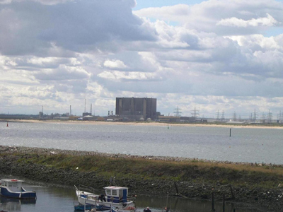
Figure 9.7. Teesside Nuclear Power Station
Values and Perceptions
Because of the finite nature of hydrocarbons, the decline in this industry was always inevitable, and with increasing issues relating to the effect of these resources on global warming, the feelings with regard to this industry are invariably mixed. The use of nuclear power is also becoming increasingly controversial because of the problems of storing radioactive waste for indefinite periods, but also in relation to the potential for possibly severe radioactive contamination by accident or sabotage, and the possibility that its use could indirectly lead to a proliferation of nuclear weapons. Renewable sources of energy may be perceived as benign, symbols of hope. Energy complexes are generally highly visible features in the landscape and often contribute significantly to levels of noise, smell and activity; they can be expected to engender strong feelings.
The area is important for its wildlife and the partly industrialised Seal Sands on the north bank of the Tees are the winter home to thousands of wildfowl and waders. Seals may also be regularly seen 'basking' in their 'man�made' or semi-natural surroundings.
Research, amenity and education
As this is a relatively recently developed Type, the extent of archaeological and historical research on the development of both the Type itself and also its typical components is fairly limited. Decommissioning of plants may allow opportunity for some research to be undertaken, with previous historic character Types possibly still well-preserved beneath these complexes in some cases. It is known that considerable extents of these industrial areas are founded on reclaimed land, often drained saltmarsh and mudflats, and infilled from the late 19th century onwards. These buried deposits may have considerable potential for preserving palaeo-environmental material as well as artefacts and features associated with estuarine environments. Public amenity is limited due to health and safety restrictions.
There has been a lot of recent interesting work being carried out on off-shore archaeology. Work such as Birmingham University's research into North Sea palaeo-landscapes is extremely important. It aims to better understand the early landscape of areas now covered by water. Whilst of undoubted inherent importance, this research also has clear implications for resource management. With policy trends towards the expansion of renewable energy, there is inevitably going to be a greater push towards wind power, particularly in off-shore locations where more consistent winds are available and there is likely to be less opposition from local interest groups. However, this HSC project and the work at Birmingham serves as a useful reminder that such projects need to remember that seabeds are as much historic landscapes as on-shore locations. As such it is encouraging to see that COWRIE (Collaborative Offshore Wind Research Into The Environment), an company set up by the Crown Estate to raise awareness and understanding of the potential environmental impacts of the UK offshore windfarm programme, has just published a guidance note for best practice in survey, appraisal and monitoring of the historic environment during the development of offshore renewable energy projects in the United Kingdom.
Condition & forces for change
Increasing concerns relating to the finite nature of hydrocarbons and the effect burning these resources has on global warming will place increasing pressure on that sector of the energy industry. Nuclear power has been the main form of alternative energy production. Renewable alternatives are fast becoming a preferred choice and there appear likely to be significant changes in the generation of energy in the study area.
Potential sources of renewable energy of relevance to this area include wind, wave and tidal power. A proposition has already been made for a potential offshore wind farm with thirty wind turbines to be sited at Tees Mouth. The Tees Valley's status as a UK centre for the development of new, cleaner energy technologies has received a major boost in recent years and has acquired an option to participate in what would be the UK's first complete clean coal power generation project. As fossil fuels run out and we seek to replace them, hydrogen may be a suitable replacement. It would seem that the Tees Valley is well placed to take advantage of the move towards the 'hydrogen economy' as it is already home to the largest hydrogen system in the UK
Rarity and vulnerability
These sites may be under threat considering that the hydrocarbon industry is on a downturn. It is important to manage these sites following their abandonment to prevent secondary pollution to the surrounding environment.
Recommendations
There may be limited scope for archaeological recording following the abandonment and/or redevelopment of these sites, particularly if it can be shown that there is archaeological or historical potential for buried remains.
Coastal and seabed developments of any sort have the potential to have significant effects on the archaeological sites and materials that make up the historic environment and this needs to be considered during the course of any such development.
Renewable energy is an essential element of the Government's programme of action to tackle climate change, and their aim is that 10% of our electricity is generated by renewable sources by 2010 and 20% by 2020. Through the Marine Bill, they aim to facilitate the achievement of this target by simplifying the licensing process for marine renewable energy installations (DEFRA March 2007, 57).
- COWRIE's (2007) recently published guidance notes for best practice in survey, appraisal and monitoring of the historic environment during the development of offshore renewable energy projects in the United Kingdom suggest a number of general principles that are applicable to sites and materials likely to be affected by coastal or offshore developments. These are:
- The use of the precautionary principle, the aim of which is to prevent damage to sites and material by proactively putting in place protective measures, rather than having to attempt to repair damage after it has occurred
- The assumption that archaeological sites should be subject to as little disturbance as possible, and should preferably, be preserved in situ
- The requirement, where preservation in situ is not practicable or reasonable, for disturbance to be offset by appropriate and satisfactory provisions to mitigate the effects of disturbance
- The requirement to create and deposit an accessible archive of the results of all archaeological investigations to ensure the 'preservation by record' of this non-renewable resource.
Sources
Publications:
COWRIE, 2007. Historic Environment Guidance for the Offshore Renewable Energy Sector
Department of Trade and Industry. August 2002. Human Activities in the SEA 3 Area.
Le Guillou, M, 1975. A History of the River Tees
Websites:
http://www.og.dti.gov.uk/downstream/refining/index.htm
http://www.northeastengland.talktalk.net/page92.htm
http://www.fuelcellmarkets.com/fuel_cell_markets/1,1,1.html
http://www.hse.gov.uk/nuclear/psr2.htm
http://www.northeastengland.talktalk.net/Teesside.htm
http://www.northeastengland.talktalk.net/Whitby.htm
http://www.gasarchive.org/index.htm
http://www.northeastengland.talktalk.net/Stockton.htm
http://www.mining-technology.com/projects/boulby/
http://www.pancrack.tv/subject.html
http://www.nationalgrid.com/property/about_background.asp
