
England's Historic Seascapes: Scarborough to Hartlepool
Cornwall Council, 2007. https://doi.org/10.5284/1000201. How to cite using this DOI
Data copyright © Historic England unless otherwise stated
This work is licensed under the ADS Terms of Use and Access.


Primary contact
Charlie
Johns
Cornwall Council
Kennall Building, Old County Hall
Station Road
Truro
TR1 3AY
UK
Tel: 01872 322056
Resource identifiers
- ADS Collection: 744
- ALSF Project Number: 4731
- DOI:https://doi.org/10.5284/1000201
- How to cite using this DOI
Introduction | Seascapes Character Types
Fishing and Mariculture
- Introduction: defining/distinguishing attributes and principal locations
- Historical processes; components, features and variability
- Values and perceptions
- Research, amenity and education
- Condition & forces for change
- Rarity and vulnerability
- Sources
Introduction: defining/distinguishing attributes and principal locations
The Type Fishery includes the following sub-types:
- Seining;
- Netting and Lining;
- Beam Trawling;
- Trunking and Potting;
- Mariculture
- Hazardous Fishing Grounds.
Sea fishing is both an ancient and unique activity. Though defying classification either as industry, agriculture or transport, it exhibits characteristics of all three (Starkey et al, 2000; 9). Historically of the huge variety of fish populating northern seas, two species - cod and herring - and their close relations, figured heavily in north-west European fisheries. Herring and related types are 'pelagic', and mainly caught in the upper layers of the sea. Such fish are normally taken during their spawning season, when they shoal in great numbers on breeding grounds. In contrast, cod, like haddock, hake, whiting, and many flat fish species mainly live on or near the seabed. Such 'demersal' fish are caught most of the year round.
Pelagic and demersal fisheries have each evolved distinctive characteristics. Herring, for example, were normally taken by drift netting, in which curtains of nets trap fish by the gills as their shoals swim through, or in purse shaped nets called seines. Baited hooks on hand or long lines have, until comparatively recently, been the most important means of taking demersal species, although stationary nets on the sea bed have sometimes been used. Later, these techniques lost ground to various forms of trawling in which bag-shaped nets were dragged along the sea floor (Starkey et al, 2000, 10).
Pelagic fisheries, such as Herring, tend to be located off the east coast and demersal fisheries, such as Cod and Haddock, are located further offshore around the Dogger Bank (Starkey et al, 2000; 19). Historically, however, every part of the North Sea can be considered a fishery, or having been fished in one way or another, from at least the medieval period, if not before. The early fisheries tended to be inshore, farmed by small craft staying out for short periods. However offshore fisheries were also farmed but it was not until the improvement of fish curing techniques in the medieval period and the age of steam, in the 19th century, that extensive and intensive fishing took place.
Today the main North Sea demersal fisheries target a mixture of roundfish species (cod, haddock, and whiting) or flatfish species (plaice and sole). Pelagic fisheries mainly target herring and mackerel. These are all predominantly for human consumption, although a proportion of the pelagic fisheries are used for fishmeal and fish oil production. There are also industrial fisheries for sandeel, Norway pout and sprat which are used in the production of fishmeal. Besides these finfish fisheries there are also fisheries for the crustaceans Nephrops, Panadalus borealis and brown shrimp. Norway, Denmark, UK and The Netherlands are the major North Sea fishing nations.
Historical processes; components, features and variability
Without doubt fishing has been an integral part of human activity since prehistory. Little direct evidence is known about prehistoric fishing activity in the area. However Mesolithic archaeological sites discovered in Danish coastal waters provide a useful analogy. Most known sites are submerged settlements and almost every one had one or more fish weirs associated with it. The largest recorded is perpendicular to the former shore at the small island of Neksel. Extending over a distance of 250m, it consists of vertical poles up to 150mm wide to which up to 4m high wickerwork panels were tied. The panels were made of perfectly straight sticks of coppiced hazel (Fischer 2004, 27).
Medieval fishing and fisheries
By 1300 AD England's east coast fisheries were a complex, highly regulated and widely dispersed industry the scale of which was immense by medieval standards. They were of international importance, supplying not only local demand but also supporting a major export trade. The main fishing centres were generally distinct from the main trading ports. In Yorkshire, Hull was the principal trading port while Scarborough led in fishing. A wide variety of species was caught, including ling, whiting, haddock, plaice, thornbacks, skate, hake, mackerel, dogfish and pollack. However the main fishing trade concentrated on herring and cod; the former proliferated off the east coast and the latter were known to congregate about Dogger Bank (Starkey et al 2000, 19).
The North Sea, Norwegian coast, and Baltic were all known to English fishermen by the early 14th century, and Iceland became familiar at the beginning of the 15th century. However it is probable that inshore fishing grounds were the most frequently exploited at this time. Herring contracts of the time generally refer to unloading fish after fishing for one or two nights, but only rarely after three. Common practice was to land catches quickly at seasonal stations for immediate salting and barrelling. By the 15th century there was a trend away from inshore to distant-water fishing as a result of the improved curing techniques that allowed vessels to stay at sea longer and so venture further. England and Wales were integrated into a network of European trade routes stretching from the Baltic to the Mediterranean, within which fish was an important commodity (ibid 2000, 20).
More is known about fishing seasons than about precise grounds. Records of fishing tithes for Scarborough indicate that they were paid according to the type of vessel used, the species of fish caught, or area worked. They reveal an all year round business. In winter, 'deep sea' herring were sought, as were inshore species from boats and cobles, and lobster, which were taken in Lent and summer. By the summer, skate, cod, and coastal herring fishing took place, the latter beginning in late summer and extending through autumn (ibid 2000, 19). Herring and cod fairs took place during the autumn, the busiest at Scarborough and Great Yarmouth. Scarborough Fair lasted 98 days, from 24 June to 29 September (ibid 2000, 19).
In the early 14th century hundreds of ships are recorded as landing herring at Scarborough during each year's season. Individual cargoes were modest, usually 0.5 to 1.5 lasts - 5,000 to 15,000 fish - worth between 10s and 60s. In Scarborough's peak year 1304-5, 237 foreign landings brought 355 lasts of herrings - 810 tonnes or 3,550,000 fish - worth �444. In 1321, at the height of herring season from June to October , around 630 ships paid quayage dues, at least half of which, and possibly two thirds 315-420 - were English. The English boats came from all over - the majority from Lincolnshire, East Anglia and Kent, but others came from as far away as Devon and Cornwall. Many foreign vessels also fished, Flemish and French in particular. Dutch boats are recorded as having landed salt, herring and other fish at Hartlepool between 1326 and 1333 and between 1303 and 1311, foreign fishermen landed an average of 21 lasts of herring a year at Whitby, worth �44 (ibid, 20-21).
Whitby was described as 'a great fischer Toune' when Leland visited it in 1536 (Frank 2002, 2). According to Burghley, writing in the 1570s, the east coast was fished by the Dutch and French. English and Dutch rights to fish anywhere and use each others ports had been agreed by Elizabeth I in 1596, though the outcome was the Dutch take-over of the English coastline (Starkey et al 2000, 35).
The English fishery was waning by the early 17th century as a result of competition from foreign vessels, especially the Dutch herring fleets. In 1609 foreigners were prohibited from fishing in all the fisheries off the coasts of Britain and Ireland, unless they bought licences: the seas were no longer free (ibid 2000, 49).
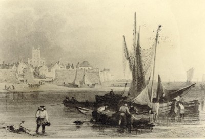
Figure 9.24. Old fishing boat etching, Hartlepool (1702) (© Hartlepool Arts & Museum Service)
The Herring Fisheries, 1750-1970s
The most important herring grounds were in the North Sea where fishermen followed the shoals down the east coast, starting at the Shetlands in late winter and ending in the waters off East Anglia in the following autumn. The autumn fishery off Yarmouth, which lasted until St Andrew's Day (30 November), was the culmination of this great annual migration of ships and men, attracting 'all the herring-fishermen of England', including those of 'the North-counties beyond Scarborough' who came in poor 'little boats, called Five-men cobbles' (Frank 2002, 132). The Dutch possessed Europe's largest commercial herring fisheries from the 17th century to mid-18th century although during the 19th century the Scottish herring fishery rose to pre-eminence.
Around the 1830s, there was a resurgence in the Yorkshire coastal fisheries. In 1834, Whitby harbour was said to be busier than ever, with boats visiting from as far afield as Cromer, Hastings and Yarmouth. By the 1836 season, some 400 vessels were reported to be engaged in the Yorkshire herring industry.
'In the 19th century Staithes yawls ventured as far north as Aberdeen and vessels from Scarborough and Filey continued fishing down to Yarmouth. Off the Yorkshire coast the main herring season was in August and September, harvest months in the agricultural calendar. By the 1870s Yorkshire harbours were packed in the late summer months with vessels come to share in the herring harvest. Zulus and fifies from the Moray Firth lay alongside stately East Anglians together with boats from Cornwall Mount's Bay and from the Isle of Man and the local fleets too. By 1880 more than two hundred boats were fishing for herring off Whitby and in 1885 it was reported that over 80 boats came from Cornwall alone, their home ports being mainly Penzance Mousehole, Fowey, St Ives and Newlyn (Figure 9.25). A few fished the off-ground with the bigger Staithes yawls, venturing as far as 60 miles from land, but usually the fishing ground was three to seven miles off Whitby.' (Frank 2002, 133).
In late mid-late 18th century the government, concerned at the state of the English fishery took measures to support and improve the industry, giving money inducements to craft that could rival the Dutch. By c1800 80 vessels based themselves at Great Yarmouth and Lowestoft (down from 205 in 1760), measuring between 45 and 50 tons, and half of them had sailed from bases in Yorkshire (Starkey et al 2000, 64).
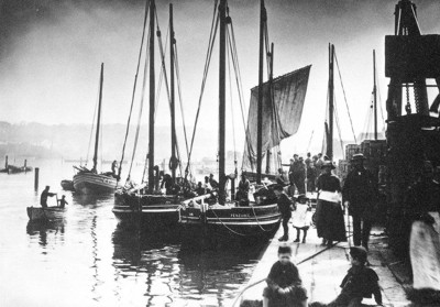
Figure 9.25. Cornish herring boats at Whitby (© Whitby Museum)
'The demise of the herring fishery at Whitby has been, by some, attributed to a series of poor seasons ... however a more likely reason was the state of the harbour. Principal complaint was the insufficiency of water in the harbour at ordinary times for the accommodation of such boats as hail from Yarmouth, Lowestoft and Penzance ... thus cargoes off load at Hartlepool or Scarborough' (Frank 2002, 147). By August 1885, 91 fewer fishing boats used the port than in the same month the previous year. Scarborough maintained its primacy as the chief Yorkshire herring port up to the outbreak of war in 1914. Between the wars, herring fishing on any scale virtually disappeared at Whitby, and was at a low ebb all along the Yorkshire coast. There was a boom again in 1940s and 1950s as Scottish boats fished off Yorkshire but this was short-lived (Frank 2002, 147-9). The change to round-the-year trawling and seine-netting contributed to the serious depletion of herring stocks in the North Sea (Frank 2002, 88).
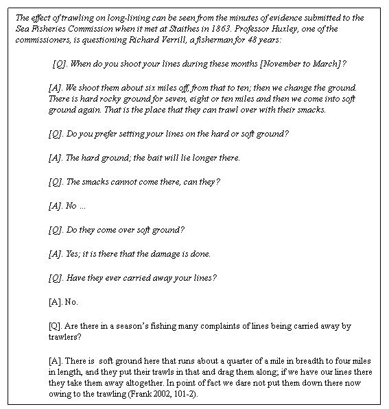
The Line and Trawl Fisheries in the Age of Sail
On the Yorkshire coast, Scarborough, Staithes, Robin Hood's Bay, Flamborough and Runswick deployed fleets of three-masted luggers, each over 50ft in length, which were fitted out to follow the great-line fishery for cod and ling off the Dogger Bank. Voyages typically lasted from Monday to Friday. A proportion of the catch was then dry salted on the shore, and later sold for consumption, much going to inland towns and cities, supplying York, Leeds, Bradford, Halifax, Thirsk and Malton. By the 1780s, Manchester was receiving supplies, and some even went as far as Liverpool. Exports provided a further valuable outlet. Some went to the West Indies and Ireland, but the major markets were in northern Spain and the Mediterranean. Towns such as Bilbao, Santander, La Coruña and San Sebastian were important to the Yorkshire trade in 1820.
In 1817 Staithes was by far the biggest fishing station on the Yorkshire coast. Out of 28 five-men boats, 14 belonged to Staithes, six to Runswick, five to Robin Hood's Bay and three to Scarborough. At the same time, there were between 250-300 smaller cobles (Figure 9.26), of which 70 belonged to Staithes, 35 to Runswick and 35 to Robin Hood's Bay. Ord writing in 1846 notes 'The fishery of Staithes - especially in cod, haddocks and herring - is very important, being the main branch of commerce and chief support of the place (Frank 2002, 18).

Figure 9.26. Whitby sailing coble (Lily WY185) (© Whitby Museum)
The changes that transformed the offshore fishing industry between 1840s and 1870s were revolutionary. Yorkshire coast ports enjoyed a considerable expansion of inshore fishing and also of increased offshore line fisheries. The two most notable areas of expansion were the herring and trawl fisheries. (Starkey et al 2000, 94). The key factor was the construction of the railway network, which radically transformed markets and distributions. The demand for fresh food had been growing since the early 18th century. The Stockton-Darlington railway line was extended to Middlesbrough in 1830, and the isolated Whitby to Pickering railway was fully operational by 1836. Many of the fishing communities from Whitby southwards were linked to the network by 1845.
Long-lining and netting
In long-line fishing a number of strings, each consisting of a main line (Figure 9.27) with baited hooks on branch lines called snoods are connected end to end and placed on or just off the seabed with an anchor and marker buoy at each end. Vessels engaged in this fishery are typically small inshore vessels, 10m or less, generally operating on grounds near their home port.
_new.jpg)
Figure 9.27. A fisherwoman fetching in the lines at Whitby (� Sutcliffe Gallery www.sutcliffe-gallery.co.uk)
Netting is predominantly carried out in two ways, using set nets and seine nets. Set nets are walls of netting up to 3m high and 70m long used singly or as a series joined end to end moored on the sea bottom. Fish are caught either by gilling or entanglement. As with long-lining, netting is confined for the most part to inshore vessels.
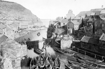
Figure 9.28. Fishing boats and nets at Staithes (© Whitby Museum)
Seining is carried out for demersal and pelagic species. Fish are 'herded' into the path of the net as the gear is hauled. Seining for Pelagic species uses purse seiners that capture shoaling fish that aggregate into large, dense concentrations near the surface by surrounding the shoal with a deep curtain of netting supported at the surface by floats. The net is then pursed under the shoal by heaving on a wire that runs through rings attached to the bottom edge of the net. Seine net vessels range from 12 to 30m whilst purse seiners range from 30 to 60m in length.
Historically long-lining for white fish from cobles was the most common activity, forming the backbone of the fisherman's year. A typical year for a sailing coble or mule began about the second week in October with the winter line fishing. A single line might have between 300 and 500 hooks; so, with each man having two lines, a three-man coble could fish up to 3000 hooks in a single night (Frank 2002, 95). This method alone was used up to the end of February, when it was carried on alongside potting for crabs and lobsters.
Boats often had both herring nets and long lines on board and engaged in netting and overing. This involved catching small spring herrings in the nets to use as bait on the big over hooks. Springtime lasted a month or six weeks and then the cobles started driving (drift-netting) for herrings. In August, however, most Whitby boats followed the main herring fishery to East Anglia which lasted through to the end of September or October, when the winter line fishing came around again (Frank 2002, 86). This basic pattern seems to have remained unchanged from at least the 1650s until the mid-19th century (Starkey et al 2000, 92).
'The lines are shot across the tide, left on the bottom for several hours, usually during the time of a tide's ebbing or flowing, say six hours. While the lines are shot one man keeps a lookout, the other two wrap themselves in the sail and go to sleep in the bottom of the coble. Each man has three lines, each line 200 to 240 fathoms, 240 to 300 hooks to each line are tied or whipped to a length of twisted horse hair called 'snoods', each about two and a half foot long, fastened to the line 5ft apart. When the lines are baited they are regularly coiled up on oval piece of wickerwork like the bottom of a clothes basket, called by Yorkshire fishermen a 'skep', at Hartlepool in Durham a 'rip'. The lines are baited by wives and children before the coble proceeds to sea, all are fastened together and when each is 240 fathoms the length of the whole is nearly two and a half miles. An anchor and buoy are at the end of each man's set of lines, or four anchors and four buoys to each coble's entire line. The buoys at the extremities are tarred dogskin, inflated like bladders with pole and flat, intermediate buoys are usually cork. The anchors are large stones, as an iron anchor is liable to get fast among rocks' (Frank 2002, 88-9).
Trawling
A number of trawling practices have been and are still employed in this area of the North Sea. Bottom Trawling is the most widely used method. Trawl nets are funnel shaped, with sides extended forward to form wings to guide fish into the funnel. The net is held open horizontally and floats attached to the upper edge of the net mouth provide lift. Weights distributed along the lower edge (ground rope) ensures good contact with the sea bottom and disturbs the fish for catching. Trawlers range in size from small inshore vessels of less than 10m to large factory ships 60m or more.
The main device used was the beam-trawl, taking its name from the beam of wood (usually elm) keeping the net mouth open. Beam length of varied from 36ft (11m) to 50ft (15.2m), while the triangular, purse-shaped net was up to 100ft (30.5m) long. The beam itself ran over the sea-bed on stirrup-shaped runners (known variously as shoes, heads, or irons) which had the effect of keeping the beam itself about three feet above the sea-floor and allowing the lower part of the mouth of the net to funnel and billow out behind it. This lower edge was attached to the ground rope. When the trawl was in motion, the fish disturbed by the ground rope are caught in the net as it passes. However the trawl also bagged anything else in the way as it swept by, and it was this feature which constituted the core of the traditional inshore fishermen's complaints against trawling. This fishing method is widely used by Dutch, Belgian and English fishermen for species such as sole and plaice (Frank 2002, 21-22).
Shellfish trawls, for species such as Nephrops or shrimps, differ very little from whitefish gear apart from being generally more lightly rigged. Scallop dredges consist of a ruggedly constructed triangular steel frame and tooth-bearing bar, behind which a mat of linked steel rings is secured. A heavy netting cover joins the sides and back of this mat to form the bag in which the catch is retained. Scallops, which usually lie in sand or fine gravel, are raked out by the teeth and swept into the bag.
In the mid-18th century trawling in English waters was mainly confined to stretches off the south west and south east coasts. Devon sailing trawlers worked out of Brixham and Plymouth, while Barking was the centre for craft trawling in the Thames approaches. Though the Barking fleets tended to limit their trawling activities to the Southern Bight of the North Sea, the Torbay smacks took the lead in opening up other grounds further up England's eastern seaboard. In the summer of 1831, two southern smacks worked the Yorkshire coast grounds and landed their catches at Scarborough (Starkey et al 2000, 73-4).
Between 1840 and 1860, trawling expanded dramatically, rapidly overhauling lining as the principal means of capturing white fish. This led to the rise of the new fishing ports of Hull and Grimsby. In 1840, the two Humber ports possessed no more than a handful of smacks between them, but by 1880 there were almost a thousand sailing from the estuary.
By the mid-1870s, the expansion of the smack trawl fishery was nearing its peak. Sailing trawlers had opened up much of the North Sea, trawling intensively to a depth of 30 fathoms [c55m] or more. In summer, they visited grounds off the Danish, German, Dutch and Belgian coasts. In winter, they mainly worked banks adjacent to the Dogger, including the Silver Pits and Botney Gut.
The widespread introduction of bottom and beam trawling had a revolutionary impact on the fishing industry in Britain as a whole. By the last quarter of the 19th century the dynamic sector of the English fisheries was North Sea trawling. The primacy of line fishing in Yorkshire's coastal villages was being challenged and by the mid-1870s, Scarborough supported a fleet of around 40 specialist trawling vessels, and at least 40 dual - even triple - purpose boats; that might go drifting and/or lining in other seasons. These vessels joined the fleets sailing out of Hull and Grimsby, but they also ranged right across the North Sea to the coasts of Holland and Denmark. From the 1880s as steam propulsion and other technological advances enhanced their range and productivity, trawling increased further (Starkey et al 2000, 94-5).
The remarkable development of the Humber ports was due to the accidental discovery, in 1843 or thereabouts, of Silver Pits. At the southern end of the Dogger Bank, and due east of Flamborough, was a deeper area marked on the Admiralty chart 'Outer Silver Pit'. One exceptionally severe winter trawling was tried there on chance: 'soles were found during that very cold season in almost incredible numbers; the nets were hauled up 'bristling with fish trying to escape through the meshes', and such enormous catches were made as the most experienced fishermen had never before thought possible. Thereafter, the development of Hull as a fishing station was rapid. From 40 trawlers in 1845 the numbers grew to 270 by 1863 and by 1877 440 smacks were registered there (Frank 2002, 20).
The central factor of such impressive growth was undoubtedly the introduction of trawling as an entirely new method of catching fish. Trawling was destroying spawn and fry, with a consequent depletion of fish stocks; and the trawl-smacks were interfering with the gear of the inshore fishermen, so taken together, the livelihoods of traditional inshore fishing communities were being threatened. The worst affected stretch of coastline in England was that between Berwick and the Humber, which includes the Hartlepool to Scarborough stretch (Frank 2002, 21-22).
Trawling had created a fishing industry, with its own socio-economic pyramid - a small group of owners speculating at the top, and a large number of workers at the bottom. It had its own national market, brought by the railways, telegraphic communication, the use of ice, and later, refrigeration. Against this kind of highly organised and powerful set of interests, the small scattered fishing communities, using traditional methods (partly out of preference and partly because of lack of capital), and operating on a communal basis within essentially local or regional economies, stood little chance in a situation of 'free' competition (Frank 2002, 25).
From about 1880 onwards the fishing industry was rapidly assuming its present-day character. Around Britain's coastline there were still thousands of small craft propelled by sail and oar; but in the Irish Sea, the Channel, and the North Sea fleets of steam-powered trawlers were operating (Figure 9.29). In 1891 the first steam screw-trawler fished off Iceland and the era of modern distant-water fishing had begun (Frank 2002, 32).
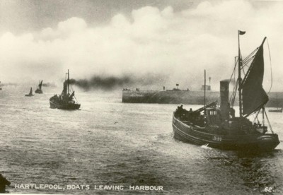
Figure 9.29. Steam Drifters leaving harbour, Hartlepool (© Hartlepool Arts & Museum Service)
The following extract comes from Albert Close's Fisherman's Chart of 1952, compiled from first hand evidence from fishermen of the North Sea. It provides a good indication on how these grounds are perceived by the men who worked them (Figure 9.30):
Area 67:
The NW of Area 67 is good for Dabs, Haddock, and Cod in July; catchy for Seine-Nets, and in the north boulders are picked up. Whitby Fine Ground is fairly good and clean. It is rough as a rule for 10 miles offshore, and strewn with wrecks. For 15 miles off shore from Scarborough to Hartlepool is stony ground.
Area 68:
All of Area 68 is good for all kinds of fish. The south half of Brucey's Garden is good for Seine-Nets. Off it's South end, from about Lat. 54.47 to 54.33 for about 14 miles West of the southern Rough of Dogger-Bank, is catchy, but trawlers, and some Seine-Nets work it. On its west edge it is catchy in 35-40 fathoms. The ST Huxley found Jan, Mar, May, June, July and Oct good months. The Western half of this area, as far north as Lat 54.45 is reported stony ground, and smaller stones in the middle of the Eastern half, extending right across to Lon 2 and from then about NE by N for another 80 miles. It averages about 120 miles in width.
Area 69:
Area 69 is good for Plaice, Haddock and Cod, but rough in places. Trawlers work all over it. Seine-nets work off the West edge in 28-32 fathoms, as marked, and in between the roughs on the Dogger. In the Dogger Bight is a good Plaice ground May to Nov. Curly weed bad May to July, Mar, May, June, July and Sept. are considered good months for general fishing. Trawlers report the easternmost Rough is little more than gravel, with a few stones. The 18 fathom shoal is a small pinnacle, with 40 fathoms on the north edge. It is rich round the foot of the shoal. A strip of stony ground, averaging about 15 miles wide runs right across the centre of this area, and in the north for 10 miles to the west of Lon 2 as far north as about 55. 10. It continues into Areas 61 and 70.
Area 70:
Area 70 is good, with patches of Roughs. Jan to Oct best. Fish: Cod, Plaice and Haddock. Good for Seine-nets clear of the roughs. Curly Weed is bad in the north of area May to Sept. The northern half of this area reported stones. These extend in a NNW direction fro 40 miles by about 10 miles wide, from the SE corner of Area 61 to about Lat. 55.45.
In 1909, a local observer wrote of Staithes: 'The lads are all going down the mines and inland to the big towns, for the line fishing is poor indeed'. By the outbreak of World War One, the last of Staithes' yawls had stopped fishing, and a tradition which can be traced back, through documentary sources, nearly 1300 years came to an end (Frank 2002, 37).
'Fixed engines, Jazzing, Blashing and Driving'
Salmon and sea trout were so prolific in the River Esk in the 1770s that part of the catch was exported by ship to London to be sold. But by 1817 they were 'very scarce, the quantity being much diminished since the establishment of the in-land (Littlebeck) alum works' (Frank 2002, 124). The closure of the Littlebeck alum works, however, allowed the Esk to purify itself and it has remained ever since one of the most important salmon rivers in England. The great quantity of fish which annually aggregate off the harbour mouth waiting to go upstream to spawn has created an important sea fishery. Tees Bay, Scarborough and, particularly, Filey and Bridlington bays all are, or have been, excellent salmon grounds (Frank 2002, 124).
One salmoning technique was known as 'fixed engines' where the end of the net is left at the water's edge (often weighted to prevent movement and therefore known as sand-fishing) and pulled out to form a hook into which the salmon are caught.
Jazzing was peculiar to Whitby where coblemen, after a storm, would catch, at the entrance to Whitby harbour, the salmon as they attempted to move upstream to spawn (Frank, 2002; 126).
Blashing, for sea trout, involved casting nets, at night in calm conditions, on the seaward side of the trout which had come in with the tide to lie in pools close to the shore beneath the rugged cliffs then making as much noise as possible (blashing) the fishermen would drive (using long sticks to slap the water's surface) the startled trout seawards and into the nets (Frank 2002, 126-7).
Trunking and Potting
Trunks and pots are small traps baited with fresh or salted bait and set on the sea bed in coastal waters to catch lobsters, crabs and Nephrops. The frames, constructed from wood, metal or plastic, are netting covered with an entrance through one or both sides, or through the ends. A laced slit in the netting facilitates baiting and removal of catch.
Historically the taking of crabs and lobsters was carried on in both summer and winter, but usually beginning at the end of March, when the weather became more settled, going on to July. It was undertaken mostly by the elder fishermen (Figure 9.31). Before about 1850 the method used was called trunking, a form of fishing which had virtually died out by the 1860s. A trunk comprised an iron hoop to which was attached a net bag. A two-man coble normally had a fleet of 24 trunks. The fishing ground was rarely more than a mile offshore and almost invariably on a rocky bottom. The depth of water ranged from a few feet up to ten fathoms, the maximum at which trunks could be effectively sunk, but usually they were shot at a depth of three fathoms. They were shot mainly at night, but fished by day if there was a swell which stirred up the sea-bed making the water cloudy, such conditions being known as crab swell. 'Clear water by night, cloudy water by day' - this was the maxim when trunking (Frank 2002, 110-11).
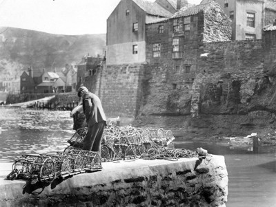
Figure 9.31. Staithes-man with pots (© Whitby Museum)
The Yorkshire coast is one of the best crabbing grounds in Britain. The introduction of pots round about 1850 and the expanding national market, created by the railways, had profound economic consequences. There was an over-fishing crisis and consequently a serious depletion of crab and lobster stocks. Potting is still an important activity for Yorkshire coblemen and the crews of some of the smaller keel-boats. Whitby alone accounts for about thirteen per cent of the national catch of crabs and lobsters (Frank 2002, 113-6).
The shore (except at the entrance of Scarborough Pier and some few other places) is composed of covered rocks, which abound with lobsters and crabs, and many other kinds of shellfish: Beyond these rocks, there is a space covered with clean sand, extending, in different places, from one to three or four miles. The bottom, from hence, all the way to the edge of the Dogger-Bank is a scarr, in some places very rugged and cavernous; in others smooth and overgrown with variety of marine plants, corallines, &c. some parts again spread with sand and shells, others, for many leagues in length, with soft mud and ooze, furnished by the discharge of the Tees and Humber' (Hinderwell, History and Antiquities of Scarborough, 1769) cited in (Frank 2002, 100).
Mariculture
There is limited mariculture in the study area although the area of Cockle Gait, near Haverton Hill, in the River Tees was farmed for cockles in the early part of the 19th century. A modern shellfishing area exists along the coast from Scarborough Bay to Cayton Bay extending to about a kilometre offshore.
Mariculture is the cultivation of marine species within coastal waters and includes shellfish farming, finfish farming and algae cultivation. Shellfish farming is the only form of mariculture activity currently undertaken in this area. In the UK, shellfish for human consumption must be harvested from designated production areas. In 2000, there were 112 shellfish farm sites active in England producing 6,718 tonnes of shellfish with an estimated value of �4.5 million (DTI 2001, 28).
Baiting
Fisherwomen played a vitally important role in the fish production process, their work carried out largely at home. Their main responsibility was to gather and prepare the bait for the long-lines. The scale of this work was enormous. Once the men had sailed, wives, sisters and daughters went down onto the bleak, exposed scaurs typical on the rocky Yorkshire coast to prise the limpets off the rocks, gathering them in wicker baskets called swills. Often if bait was exhausted in one area the women would travel great distances, round trips of up to 30 or 40 miles (48-64 km) to acquire bait from other sources, eg Staithes women are recorded as having walked to Robin Hood's Bay on such a search (Frank 2002, 165).
By far the most popular and effective bait were mussels which once they had been gathered needed to be skaned (skeined)- the removal of the soft part, the actual bait, from the shell. A crude guide, for a single night's fishing the number of hooks to be baited for the crew of the three man coble ranged from a minimum of 2600 to a maximum of 3360. The yawls and mules, larger boats, used an even greater quantity of bait; and given that long-lining was the dominant mode of fishing from the Humber to the Forth, until the advent of trawling, it was obvious that prodigious quantities of bait were used every year (Frank 2002, 165).
Unsurprisingly bait became increasingly difficult to obtain. Increased landings of fish by trawlers had the effect of depressing the market with the consequence that line-fishermen were having to double the quantity of their gear in an attempt to achieve the same financial return with consequential upsurge in demand for bait. This shortage of mussels saw growing reliance on limpets (called in local dialect 'flithers') (Frank 2002, 157).
'Flither was the name given by North East Coast fishermen to their preferred baitstuffs (Figure 9.32). When a fisherman, or his wife, goes out flithering, it's a limpet that may come off the rock but a flither that goes in the basket. A limpet would be discarded. This is because there are separate species of limpets on a rocky shore, something that is apparent only to those dealing with them....Poor-quality bait is orange or red in colour. Bait which catches fish is grey....In order to distinguish between the two, fishermen named the preferred bait 'flithers' and the poor stuff 'limpets' (Whittaker 1999, 103).
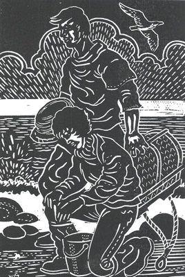
Figure 9.32. Linocut of a fisherman collecting 'flithers' from a rock (© Mel Whittaker)
'Cuvvining' was yet another important form of gathering. 'Cuvvin' is the local dialect word for the edible winkle (at Staithes they are called 'checkers'). These were gathered on the rocky scaur[s] and sold to local shellfish dealers (Frank 2002, 200).
Whaling
Whaling from Whitby began in 1753, when the Henry and Mary and the Sea Nymph sailed for Greenland. It drew to a close in 1837. There was 'never a trade so colourful, so crude, so fulfilling, and so destroying' (Dykes 1980, 6).
With the increasing oil demand for industry, whalebone for corsets and umbrellas, and seal skins for clothing and fashion, the number of vessels involved in whaling multiplied rapidly, and by the late 18th century Whitby had between ten and twenty, a few locally built. In the peak years Whitby had proportionately more people involved in the trade than any other place in Britain, including Hull. At the time of the first national census in 1801 the greatest number of whaleships to leave in one season was twenty. Stockton, at this time the most important port on the Tees, also had a couple of vessels, and Scarborough had one ship.
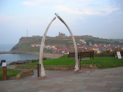
Figure 9.33. A whalebone arch stands at Whitby, commemorating the once large whaling industry (© Dave Hooley)
'The whaleships returned to Whitby in late summer or in autumn. The ships were still greasy and most of the men burned brown. Crowds would gather and longshoremen would descend upon the ships to remove the casks of oozing blubber, the boiling of which took place in four yards, two at each side of the river, and would have the town stinking with a peculiar, oppressive, and lingering smell. The blubber that they brought back had to be rendered into oil, the whalebone cleaned, cut and shaped, and finally all the produce had to be taken to the 'manufactories', either by coaster, or by horse and cart' (Dykes 1980, 7).
One of the most famous whaleships from Whitby was The Esk. The Captain was William Scoresby, junior, aged 26, a local man, son of a famous whaling father, and himself an unusual combination of whaling captain and scientist, collecting material for his superlative two-volume work on whaling and the Arctic, which was published in 1820 (Dykes 1980, 10). Polar bears were sometimes killed for food during whaling expeditions and cubs would be captured and kept on deck in a barred barrel or fastened to a point and fed whale meat. Back in England the animals would be sold to fairs and zoos. William Scoresby captured one such cub on one of his voyages on The Esk, training it to be led on a lead like a dog. Back in Whitby, however, the animal, confused by the noises and the movement and smells, broke free from the ship and ran into the town. Eventually the bear was cornered by a great mass of men, women and children with guns, pitchforks and dogs. Fortunately, Captain Scoresby arrived before anyone was hurt or the animal killed, and added to his reputation by pushing through the crowd, walking up to the bear - which licked his hand with its long rough, tongue - tying a length of rope around its neck, and leading it away. Soon afterwards the animal was taken to London's Tower Zoo (Dykes 1980, 10).
'Making ends meet'
From the 1780s to the late 19th century the Yorkshire coast fishing industry was a story of cyclical change and adaptation with periods of plenty and prosperity interspersed with times of dearth and decline. Dual economies, in which effort was alternated seasonally between landward agriculture or industry, and the sea, were widespread (Starkey et al 2000, 81). Within the area there were many shifts in the relative importance of different fisheries and fishing stations. Along the 110 miles of seaboard between the Humber and the Tees there were more than twenty settlements containing at least a few individuals who fished. Most were specialist fishermen, but farmers may have also worked as part-time fishermen and in the 19th century some men worked in the iron mines in winter and went fishing in summer. The pattern, it seems, was that, as alternative employments became available during periods of prosperity, fishing as an occupation declined. Conversely, when the local economy slumped, men resorted to fishing as their chief means of subsistence (Frank 2002, 2). This suggests that while fishing was regarded as the least favoured option, it also served as a vital lifeline.
During times of hardship many fishermen would walk the rocky scaurs along the coast as the tide went out in search of jet, sea coal, firewood, or anything washed up by the sea which could be converted into money. At Whitby this was simply called 'beachcombing', but at Runswick and Staithes it was known as 'ploagin' (Frank 2002, 191).
Shipwrecks afforded other ways of augmenting fisher-family incomes, especially when saleable goods could be salvaged; and since one of the main north-south shipping lanes from Tyne, Wear and Tees passed close to Whitby wrecks occurred frequently.
Other part-time jobs taken by fishermen in times of bad weather included 'bush beating' on the moors for shooting parties, 'game-driving', baiting, and potato-gathering or 'tatie-picking'. 'Gathering' was another activity, harvesting fruits of the hedgerow and fields. Another secondary income, in this case illegal, was poaching game from local estates (Frank 2002, 196-8).
Values and Perceptions
Modern fisheries are increasingly coming to the attention of the wider general public with the concern that there is over fish stocks and sustainable practice. Fishing communities livelihoods are intimately tied to the productivity of the seas. Today in Staithes it is possible still see local women wearing the traditional bonnet or fishermen in their ganseys, the heavy, oiled wool jersey with its locally distinct pattern. These small coastal settlements perched or tucked behind headlands and steep cliffs are particularly reminiscent of an era gone by.
Story and superstition are still commonplace. Even today some local fishermen will not put to sea if, while going down to their boat they meet a woman or someone mentioned a pig!
Modern perceptions of fishing are often that it is now destructive of fish stocks and the sea-bed. But it is also still seen as an important element in the local economy in many places. There are deep cultural attachments associated with fishing, especially in Whitby, Staithes and Scarborough.
Research, amenity and education
Trawling provided one of the first indicators of the wealth of the submerged prehistoric archaeology of the North Sea. Trawling and dredging have recovered material that otherwise would have gone undetected, and have raised the public and professional profile of pre-inundation archaeology.
There is considerable potential for further research into the history of fishing, particularly its early development and the numerous catching, storing and processing techniques employed. Such research could inform strategies for sustainable fisheries, using the historic environment to identify patterns, trends and materials used. The potential for social and economic research also exists.
Condition & forces for change
The fisheries represent the 'farming use of the sea' and we know more about their practice rather than the exact locations of specific areas of activity. Some fishing practices will impact on physical remains more than others - the obvious distinction being between the more damaging trawling methods and less damaging pelagic netting and long-lining methods. The material evidence left by trawling activities includes, most noticeably, the trawl scars on the seabed itself. The destructive tracks tear and break up the surface of the seabed as they sweep for fish. Whilst on the one hand this offers an opportunity to recover otherwise missed archaeological artefacts, on the other it clearly disturbs deposits and features.
Gear and nets often become snagged on the rocky bottom and on obstructions and wrecks. Nets, lines, hooks, anchors not to mention the vessels themselves, are lost or abandoned. These features occur more frequently in those areas identified as 'hazardous foul grounds', being 'catchy, 'sharp' or 'rough'. Any survival of objects, however, depends on materials used and prevalent environmental conditions.
Cumulatively, modern fishing methods have greatly reduced many fish stocks to the point of extinction. Herring is no longer abundant in the North Sea; the massive catches of the 1940s and 1950s took their toll with fleets of vessels, taking fish, big and small indiscriminately, and depleted stocks fell to a dangerously low level (Frank 2002, 152).
Countless millions of nutritious herring have in the past been spread on the land as manure; dumped back, dead, in the sea, or, latterly have been consigned to pet-food factories. If, as a result of bans and restrictions on fishing, the North Sea herring does recover there will have to be strict international legislation to prevent them being decimated yet again (Frank 2002, 154).
The effects of fisheries in the North Sea are widespread and ecologically important, and the removal of target species impacts the whole North Sea ecosystem. At present, 30 - 40 % of the biomass of commercially exploited fish species in the North Sea is caught each year. There is concern about the stocks of herring, cod, haddock, whiting, saithe, plaice and sole which are close to or outside Safe Biological Limits. Catch levels for many fish stocks are almost certainly not sustainable (DTI 2001).
Both the restrictions on cod and plaice have caused the displacement of fishing activity away from traditional grounds and towards the oil and gas fields of the North Sea. There is some evidence of a slight increase in beam trawl activity in the Central and Northern SEA2 regions, since the gear was first used in the southern North Sea during the 1960s. This may have implications for the safety of both the fishing vessels and underwater structures associated with the hydrocarbon industry when they come into contact (DTI 2001).
Further causes of decline has been pollution in rivers, and the construction of weirs and other obstructions that have denied access for spawning fish (DTI 2001).
Rarity and vulnerability
The Fisheries of the North Sea have a long and complex history and contribute a distinctive and important aspect in the history of British fisheries. Traditional fishing practices such as long-lining have been declining since the advent of trawling. Generally fisheries are in a period of remittance, quotas and restricted fishing grounds impacting on the scale, range and sustainability of the mid-late 20th century industry. Important archaeological finds associated with wrecks, inshore fishing and coastal potting areas may further inform the nature and finer details of the history of this industry. Medieval and earlier, prehistoric practices are likely to have left evidence as yet uncovered.
Archaeological sites and wrecks are likely to be vulnerable to erosive environmental marine processes and the longer the submergence the greater the deterioration. Any lost gears or other equipment made from organic material would rapidly break down, although metal fittings and such like may still be evident.
Intrusive offshore industries may also impact on the material culture left by fishing in the same way they impact on palaeo-landscapes and wrecks.
Recommendations
Continued control over exploitation of fish stocks is necessary if they are to be sustained. This has obvious implications for the people whose livelihoods depend on the fruits of the sea. Understanding historic practices and their impact on the fishing resource may contribute to the long-term sustainability of sea fisheries.
Consumer pressure might encourage more sustainable fishing practice. For example, the Marine Stewardship Council has accorded the British South-West mackerel hand-line fishery the status of 'sustainable fishery', since, it is suggested, 'growing numbers of consumers will only purchase products from fisheries that do not damage stocks or the marine environment (Fishing News, 7 Sept 2001).' (Frank 2002, 217)
'One possible solution that suggests itself is the revival of line fishing, which with improved marketing, might secure a premium for the fishermen, since line-fishing is both conservation-friendly and provides better quality fish.' (ibid, 218).
Remains of historic fisheries survive in a variety of conditions. Archaeological assessment should be undertaken for any extensive development in this part of the North Sea.
The European Union's Common Fisheries Policy (CFP) was adopted in 1983, with the objective of ensuring that declining fish stocks are exploited responsibly - protecting the environment and the interests of the fishing industry and consumers.
The CFP imposes a regime of equal access for vessels from all member states in the EU's exclusive fishing zone, 200 nautical miles (370.4km) from its coastline. Within this zone, member states have a 12-mile (19.3km) zone around their own coastlines within which their own fishing vessels have exclusive rights. Atlantic and North Sea fish stocks are sustained through a system of Total Allowable Catches (TACs), which are divided into national Quotas. However, these systems are notoriously difficult to enforce.
The UK needs to devise a protocol for reporting archaeological and biological finds made during trawling, similar to that already opperative in the Neatherlands (Dutch trawlers report around 10 tons of artefacts such as mammouth bones each year from the North Sea). Perhaps a scheme like that already in operation by the British Marine Aggregate Producers Association (BMAPA) and English Heritage (EH), who have co-operated in developing a protocol for reporting finds of archaeological interest to an implementation archaeological service to facilitate use of the Protocol by the marine aggregate industry. In addition operators are encouraged to strictly observe a jointly developed code of practice that includes mapping of the seabed prior to dredging in order to establish the positions of any wrecks and debris and the potential for submerged prehistoric landscapes.
Sources
Publications:
Albert Close' Fisher mans Chart of the North sea, 1952.
Department of Trade and Industry, 2001. SEA 2: North Sea Fish and Fisheries: technical report 003. DTI
Dykes, J, 1980. Yorkshire Whaling Days. Dalesman Books.
Fischer, A, 2004. Submerged Stone Age - Danish examples and North Sea potential. in NC Flemming (ed), 2004 Submarine prehistoric archaeology of the North Sea: Research priorities and collaboration with industry. CBA Research Report 141. English Heritage/Council for British Archaeology
Frank, P, 2002. Yorkshire Fisherfolk. Philimore, Bodmin
Scarborough Archaeological & Historical Society, 2003. A guide to historic Scarborough.
Starkey, DJ, C. Reid and N. Ashcroft, 2000. England's Sea Fisheries: The Commercial Sea Fisheries of England and Wales since 1300.
Whittaker, C and M, 1999. Yorkshire Journal 23, Spring 1999.
Websites:
http://www.northseatrail.co.uk/
http://www.jncc.gov.uk/page-2529
http://www.wessexarch.co.uk/projects/marine/bmapa/index.html
