
England's Historic Seascapes: Scarborough to Hartlepool
Cornwall Council, 2007. https://doi.org/10.5284/1000201. How to cite using this DOI
Data copyright © Historic England unless otherwise stated
This work is licensed under the ADS Terms of Use and Access.


Primary contact
Charlie
Johns
Cornwall Council
Kennall Building, Old County Hall
Station Road
Truro
TR1 3AY
UK
Tel: 01872 322056
Resource identifiers
- ADS Collection: 744
- ALSF Project Number: 4731
- DOI:https://doi.org/10.5284/1000201
- How to cite using this DOI
Introduction | Seascapes Character Types
Military Defences
- Introduction: defining/distinguishing attributes and principal locations
- Historical processes; components, features and variability
- Values and perceptions
- Research, amenity and education
- Condition & forces for change
- Rarity and vulnerability
- Sources
Introduction: defining/distinguishing attributes and principal locations
The Type Military Defences includes the following sub-types:
- Anti-tank defences;
- Artillery;
- Fortifications;
- Anti-landing features.
Components of this Type include:
- batteries and gun emplacements
- castles and forts
- moats and dikes
- town walls and gates
- minefields
- pill boxes
- battlefields and sites of battles
- naval warships and submarines (including wrecks)
Military coastal defences can be found all along this stretch of coast, although they tend to be most densely concentrated around the main ports, in particular around the Tees and Hartlepool.
Historical processes; components, features and variability
The north east, perhaps more so than any other region in Britain, has a long history of violence and conflict. From the Roman period onwards it has been an important border zone, and its east-facing coast has been seen as a vulnerable flank, open to attack from both elsewhere in Britain and from across the North Sea' (Petts and Gerrard 2006, 211).
Preventing attacks of a seaborne nature was all but impossible in a pre-industrial society. The Romans built military lookouts (signal stations) along this stretch of coast at Scarborough, Goldborough, Ravenscar and Huntcliff for this purpose. Scarborough's military lookout was subsequently built upon and used for defensive purposes by the Saxons. The first substantial stone-built castle in this area was also built at Scarborough, founded by William le Gros around 1136 and was further strengthened and rebuilt when it was seized by Henry II in 1154.
When the Vikings began attacking the east coast in the late 8th century, there was generally no warning until their sails appeared over the horizon. Although some beacon systems did exist to alert those living inland (chains of fire beacons set on hilltops within sight of each other), it was impossible to concentrate naval forces to intercept a fleet already in sight of the shore. However destroying a fleet already known to be on its way was a possibility (Friel 2003, 35).
'The Norman Conquest of 1066 saw the beginning of a new phase of war and conquest in the British Isles, re-orientating England toward continental Western Europe and away from the Scandinavian world' (Friel 2003, 49). Naval expeditions mounted from England were rare in the 12th century. A rising in 1297, led by William Wallace in Scotland, severely damaged the English forces and their Scots supporters, and was followed by an invasion of Northern England and a temporary revival of a Scottish Kingdom. In 1318 the Scots and Flemish attacked the East coast of England. Sea power was of critical importance for the re-supply of English land forces. The defeat of England by the Scots in that episode was, in part, due to the failure of English Kings and commanders to secure their seaborne supply-lines (Friel 2003, 53).
'In the late 13th century the naval defence of England was divided into the Northern and Western Fleets, the Northern normally covering the coast from Thames to Scotland and the Western covering the seaboard from the Thames to Bristol. The naval expedition, the sea patrol and the coastal raid were the commonest types of naval operations that English ships undertook in the medieval period' (Friel 2003, 57).
Large-scale naval battles were very uncommon during the medieval period, however, and all of those in the Hundred Years War took place near the coast. Instead, attacking a fleet in an anchorage or a restricted waterway, or intercepting a fleet passing close to the coast was favoured. It was not until the addition of shipboard guns that sea battles became more common as a form of naval warfare. Shipboard guns were used in small numbers by the English and others from the 1330s, but they were essentially small anti-personal weapons. Even Henry V's biggest gun-armed ship only had seven cannon (Friel 2003, 58).
'Defensive castles were appearing on ships by the late 12th century. These were at first rather makeshift-looking structures. Medieval sea battles were normally resolved by boarding actions. Over the course of time castles became a normal part of the structure of some vessels, particularly warships, although many medieval merchant men may have sailed without them' (Friel 2003, 80). The numbers of guns on ships increased markedly in the second half of the 15th century, however, but these were still fairly small-calibre weapons. By the late 15th century large warships had multi-stage castles as a matter of course, a change perhaps mainly dictated by the massive increase in the number of guns carried by large combatants. However, most warships did not carry large guns until the 16th century (ibid).
The Dogger Bank has been the site of several naval actions. During the War of American Independence, a Royal Navy squadron fought a Dutch squadron on 5th August 1781 in the Battle of Dogger Bank. During the Russo-Japanese War, Russian naval ships opened fire on British fishing boats in the Dogger Bank incident on 21th October 1904, mistaking them for Japanese torpedo boats. In the First World War, the area saw the Battle of Dogger Bank (1915), a naval engagement between the Royal Navy and German ships which were intending to shell the Yorkshire coastal towns of Scarborough, and Whitby and the town of Hartlepool in County Durham.
By the 20th century the impact of warfare on the United Kingdom was enormous. For the fifty years prior to the First World War, Britain's defences had been concentrated on the protection of her naval bases, given that the main defence of the country was considered to rest in the Royal Navy. Military structures were confined largely within the ports and the garrison towns, although some fortification of vulnerable expanses of coastline was carried out. The army served principally overseas in the protection of the Empire.
A massive reorientation of Britain's defences occurred in the first decade of the 20th century, from seeing France as the chief enemy, to Germany. The industrial centre at Hartlepool made it a key target for Germany in World War One (WWI). The first German offensive against Britain was mounted at Hartlepool on the morning of 16th December 1914, when units of the Imperial German Navy bombarded Hartlepool, West Hartlepool, Whitby and Scarborough with a total of 1150 shells, killing 137 people and wounding 592. Two coastal defence batteries at Hartlepool returned fire, firing 143 shells, damaging three German ships including the armoured cruiser SMS Bl�cher. Scarborough Castle received its last great assault during WWI, when two German warships bombarded the town causing a great deal of damage and destroying both the barracks and the coastguard station. Shells also damaged some of the walls and blew a large hole in the castle keep (Waters 2005, 7). There was also serious damage caused to Whitby Abbey during this episode.
Germany also attacked the Home Front with unrestricted submarine warfare, which sank many merchant ships carrying supplies to Britain. In 1917 the Germans almost succeeded in starving Britain out of the War. The existing South Gare Marine Club was a sub-marine mining establishment between 1887 and 1922, housing submariners who helped to defend the mouth of the River Tees by electrically-fired underwater mines (Figure 9.66). The establishment had a fortified boundary wall which used to house quick-fire guns. The wall and its gun slits are still visible from Paddy's Hole.
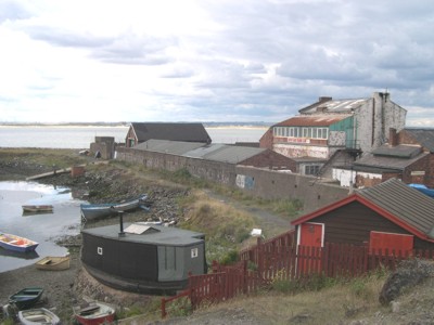
Figure 9.66. Former sub-marine mining establishment on South Gare (now South Gare Marine Club)
The stretch of water between the Humber and the Tees was also a particularly dangerous place for shipping during WWI, because at least forty-two U-boats operated in this area during this time. Between them they sank no less than 120 ships with torpedoes, over 100 by mines and many more that could not be accounted for. At least another 80 merchant ships were also lost between the Tees and the Tyne during that conflict (Young 2000, 19).
The surprise attacks on Scarborough, Whitby and Hartlepool during WWI caused outrage throughout the country. An army recruitment office set up in Scarborough did a roaring trade after posters appeared in all three towns (Figure 9.67). One proclaimed: "Men of Yorkshire, join the new army and help avenge the murder of innocent women and children in Scarborough, Hartlepool and Whitby. Show the enemy that Yorkshire will exact a full penalty for this cowardly slaughter. ENLIST TODAY"
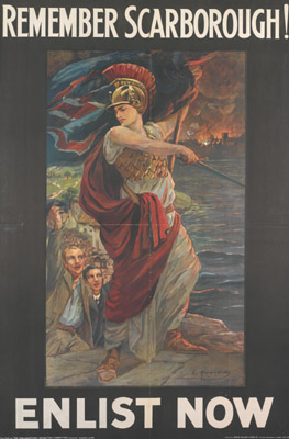
Figure 9.67. Army recruitment poster for WWI (© Imperial War Museum)
At the onset of World War Two (WWII) Britain was ill-prepared to defend against an expected invasion by Germany and the fortification of the east coast on a serious level at this time stems from that, the result being a government policy that was to turn Britain into a fortress. The War Office correctly guessed that the Germans would attempt a landing in the south and south-east of England. However, major diversionary raids elsewhere could not be ruled out and, as a result, near enough the whole of Britain was fortified. Beaches were to be made impenetrable. Scaffolding was erected on most beaches so that landing craft could not land on a beach. Behind the scaffolding were placed thousands of mines. Behind the mines was barbed wire and behind the wire were more land mines. Finally, yet still on the beach, were anti-tank blocks - 13 ton concrete blocks designed to impede the movement of the tanks. Behind the beach area, pill boxes were built to house machine guns and to create a killing field.
In order to bolster defences, earlier fortifications were reused, such as the Heugh Gun Battery at Hartlepool. In addition, large numbers of pillboxes and antitank obstacles were hastily constructed, particularly along those parts of the coastline where the threat of landings was highest. Much attention was paid to defending the broad, firm sandy beaches to the north and south of the River Tees. Pillboxes, barbed wire and minefields were erected, supported by a range of anti-tank obstacles, including ditches, iron rails, wooden posts and railway sleepers (Green 2006, 4).
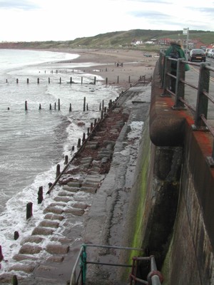
Figure 9.68. Anti-tank defences now incorporated into the sea wall at Sandsend
The steelworks and the port at Teesmouth were vital during WWII for the supply of steel for war machinery. This made the South Gare once again a prime target for enemy attack. The site was heavily defended with a wide range of defensive structures including barracks, gun batteries and range-finding towers. To protect other valuable industrial complexes in the Tees Valley, a number of Night Bombing Decoy sites were also constructed. The remains of some structures are still visible here today. At the end of South Gare and near to Fishermen's Crossing, mounds mark the location of the Pasley Battery which housed large breech loading guns and the 6-inch Battery. These guns were only ever fired once in anger at a German plane, which was seeking to mine the mouth of the Tees and were removed after the war.
Minefields were also laid in many parts of the North Sea during WWII. The vast majority of historic minefields in the North Sea have now been cleared as a result of an extensive mine clearance effort since WWII.
Values and Perceptions
Both public and official opinion has now largely turned against the idea that these military works are an eyesore and inconvenience in the landscape to be removed without consultation wherever possible. Now, they are seen as part of the overall historic legacy of the landscape, and, in the case of the Second World War, of particular significance in terms of their place in the front line of the fight for freedom.
Research, amenity and education
The military remains of World War One and World War Two have been one of the most active areas of research for special interest groups in recent years. The larger coastal defence batteries from World War One are well known, although there has been less work on the more ephemeral remains from 1914-18, such as practice trenches, early industrial sites and damage from enemy action. In general, the remains of the 1939-45 conflict have attracted the greatest interest, reflecting both the greater number of surviving features and the fact that action is still within living memory of some members of the population (Petts 2006, 190).
A result of an increased public interest in surviving military remains was the Defence of Britain Project (DOB) (1995-2002), which ran under the auspices of the Council for British Archaeology. It has sought to record what survives of the multiplicity of military structures erected during the last momentous century. The main purpose of this work is to inform the responsible heritage agencies, at both local and national level, so that the long process of decay and destruction can be halted and individual surviving structures evaluated for future preservation. There is still much information in private hands, however, that was not submitted to this project and remains to be explored.
While military structures such as pillboxes are well represented in the archaeological record, civilian defences are rare. To address this problem, and to commemorate and celebrate the 60th anniversary of the end of World War Two, Tees Archaeology joined forces with Hartlepool Arts & Museums Services and Redcar & Cleveland Museums Services, to launch 'Dig for History' Project, which was a public appeal for information on an often-overlooked archaeological aspect of World War Two - the 'Home Front'.
Although many sites are on private property, a number of military sites are accessible to the public.
Condition & forces for change
Military remains from World War One are a fast disappearing resource. Although events from this war may not have had the same impact on the region's environment as those of World War Two, there are still many surviving remains, ranging from the batteries at Hartlepool, to rifle ranges and practice trenches, but these features are often ephemeral, and in many cases their origins have been forgotten (Petts and Gerrard 2006, 190).
Along the beaches and scattered through the dune systems there are still the remains of many of the WWII pill boxes and gun emplacements. Sadly, many of these are suffering from the effects of time, neglect and vandalism, and from loss to coastal erosion. In West Coatham the gun emplacements that were located here are now only visible as an area of raised ground and a spread of rubble. Other recognisable WWII structures which survive today include reinforced concrete anti-tank cubes, eg at Hart Warren, North Gare Breakwater and at Sandsend.
The few historic minefields that remain uncleared in the North Sea are considered safe for surface navigation, although a real danger of encountering unexploded historic ordnance still exists with regard to anchoring, demersal trawling or any form of submarine or seabed operations. Conventional and chemical munitions may also still be encountered at sea. Collectively these may include buoyant mines, seabed (ground) mines, torpedoes, depth charges, bombs, missiles, artillery shells and gas cylinders. These munitions are dangerous and sensitive, particularly to shock or vibration, even if they have been in the water for many years. These weapons are sometimes picked up in trawls, or as a result of other seabed operations, particularly dredging, often in waters comparatively distant from where they were laid, fired, dropped or dumped.
Rarity and vulnerability
Some of the historic structures are protected through being Listed Buildings or Scheduled Monuments.
Recommendations
The DOB project highlights the value of selecting significant examples that survive in good condition, and preserving them for their historic importance and their potential educational value. In the latter regard, many defence structures that have good public access could undoubtedly be set out with information boards, and become part of 'heritage walks', so that their place in our history, and in our landscape, can be more readily understood. This would also raise consciousness about 20th century archaeology generally.
Further local studies would also prove valuable, using documentary resources together with detailed field work that might also build in a programme of oral testimony - elderly inhabitants of an area may well have many memories of the defence works and the soldiers manning them, particular in towns and villages that were nodal points and anti-tank islands, and if so these need to be collected before the WW2 generation dies out completely (Petts and Gerrard 2006, 211).
A more detailed analysis for the setting of fortified sites would prove beneficial, as would a survey of the re-use of earlier sites by later defences and an analysis of the impact of changing military technology on the design and location of fortifications (Petts and Gerrard 2006, 211). The recovery, analysis and conservation of navel vessel wrecks are also of great importance (Petts and Gerrard 2006, 211).
Detailed modelling of networks of signal stations and beacons for all periods is also likely to be a productive line of research, both for exploring the inter-visibility between known sites and as a predictive tool to locate gaps in the distribution of known sites (Petts and Gerrard 2006, 211).
There is now a growing business in 'heritage tours' looking at military sites of WWII. At present it is mainly confined to places associated with the British and American air forces, but important points of the defended landscape such as groups of pillboxes, anti-tank obstacles and coastal forts would also be valuable additions to itineraries (Foot 2000).
Sources
Publications:
Friel, I, 2003. Maritime History of Britain and Ireland.
Foot, W, 2000. Landscape of War, in British Archaeology Issue no 54 August 2000.
Green, G, 2006. The Home Front: Teesside Defences During World War II. Tees Archaeology.
Hagland, J, 1985. The oil adventure in the North Sea seen from Norway, in A Bang-Andersen et al (eds), 1985, The North Sea. A Highway of Economic and Cultural Exchange. Norwegian University Press,
Herring P, 1998. Cornwall's Historic Landscape. Cornwall Archaeological Unit, Truro
Petts, D and Gerrard, C, 2006. Shared Vision. The North-East Regional Research Framework for the Historic Environment. Durham University.
Waters, C, 2005. Then & Now. Scarborough. Tempus
Websites:
http://www.wildlifetrust.org.uk/teesvalley/Heritage/Military.htm
http://www.britarch.ac.uk/projects/dob/review/index.html
http://en.wikipedia.org/wiki/Dogger_Bank
http://en.wikipedia.org/wiki/Hartlepool
http://www.bbc.co.uk/schools/worldwarone/hq/hfront1_03.shtml
