
England's Historic Seascapes: Scarborough to Hartlepool
Cornwall Council, 2007. https://doi.org/10.5284/1000201. How to cite using this DOI
Data copyright © Historic England unless otherwise stated
This work is licensed under the ADS Terms of Use and Access.


Primary contact
Charlie
Johns
Cornwall Council
Kennall Building, Old County Hall
Station Road
Truro
TR1 3AY
UK
Tel: 01872 322056
Resource identifiers
- ADS Collection: 744
- ALSF Project Number: 4731
- DOI:https://doi.org/10.5284/1000201
- How to cite using this DOI
Introduction | Seascapes Character Types
Military Facility
- Introduction: defining/distinguishing attributes and principal locations
- Historical processes; components, features and variability
- Values and perceptions
- Research, amenity and education
- Condition & forces for change
- Rarity and vulnerability
- Sources
Introduction: defining/distinguishing attributes and principal locations
The Type Military Facilities includes the following sub-types:
- Military practice areas;
- Military bases;
- Military dumps;
- Military airfields;
Components of this Type include:
- army bases and barracks;
- radar bases and listening posts;
- firing/rifle ranges;
- naval docks and bases
- submarine bases and exercise areas
- RAF bases.
Historical processes; components, features and variability
During WWI the Defence of the Realm Act enabled vast tracts of land to be requisitioned for camps, airfields, munitions production, and storage. Half a million men were stationed in Britain as a home defence force, and coastal defences were greatly extended. Although much of the training of the army took place across the Channel, or on the other battle fronts, some troops practised the construction of fieldworks for trench warfare, the distinctive scars of which can still be found today.
At the outbreak of WWII, under the Defence Regulations, the power to requisition and make use of land was given to service and civil departments alike, and, in 1944 at the peak period of the militarisation of the landscape, some 11� million acres (4.6 million hectares) was under some form of military control.
The closest large-scale military base to the study area is RAF Fylingdales in the North York Moors National Park. There are several designated military Practice and Exercise Areas (PEXAs) at sea within this study area which are in use or available for use by the Ministry of Defence for practice and exercises with or without the use of live ammunition. These include RAF practice areas, submarine exercise areas and firing danger areas.
On land in the past musketry and artillery practice took place at designated firing ranges. Ranges once existed at Thornaby, Saltholm and at Scarborough Castle. Today, however, such practice areas tend to be located within military bases themselves.
Within this study area barracks (military houses) were formally located at Scarborough Castle and at Scalby Mills, and there is still the remains of a Zeppelin listening post at Boulby (Figure 9.69) and a radar base at Ravenscar. A WWII radar station was also located at Kettleness while it was superseded by a Rotor Type radar at East Barnby in 1950s, but closed after a fire in the 1960s.
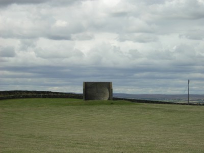
Figure 9.69. Remains of a Zeppelin listening post at Boulby
The existing South Gare Marine Club is the site of a former WWII submarine base. This was a sub-marine mining establishment between 1887 and 1922, housing submarine mariners who helped to defend the mouth of the River Tees by electrically-fired underwater mines.
Values and Perceptions
Although consisting of fairly small pockets of land, the Type dominates the areas where it exists, both physically and, through security devices like fences, psychologically.
Research, amenity and education
As defence installations, active modern components are generally secret, but military features from earlier periods have received considerable attention from military historians. As an instance of the nation state impact at local level, military installations have considerable historical importance. The inherently competitive nature of warfare means that features change more rapidly in this sphere of human activity than most others and there is scope for much detailed archaeological research. While operational, there will be little or no potential for amenity use but once decommissioned, military sites have considerable potential, being dramatic, exotic and disturbing sites.
Condition & forces for change
Military installations are normally impositions by the State on a landscape for national strategic reasons and interaction with other Types is minimal beyond service relationships (victualling, recreation, some accommodation). Some of these features form well-known landmarks.
The modern components, being in use, will be well maintained but, as these are active installations, the condition of earlier features may be impaired. As noted above, earlier features are vulnerable to alteration or removal by changes in current installations. The armed forces do take their responsibilities to historic buildings seriously. Defence cuts at government level threaten the existence of current installations. Decommissioning may involve the removal of dangerous or sensitive features.
Unless re-using earlier military sites (eg Scarborough Castle) the evidence for time-depth is confined to features (e.g. hedges and tracks) captured within secure fencing and not obliterated.
The impact of military activity on archaeological sites is linked to the level of use of those sites. Direct impacts are a product of construction, and operations such as the use of tracked vehicles, trench digging, and explosions. All of these activities can bring about the removal, disturbance or exposure of archaeological remains, and the artillery and bombing ranges could also have a significant impact on the inter-tidal and sub-tidal zones. A special problem identified by the Ministry of Defence (MOD) is the disposal of litter, rubble, spoil, and military equipment. The excavation of pits to dispose of rubbish may result in intrusion into, and extraction and exposure of archaeological material (Fulford et al 1997, 199).
Rarity and vulnerability
This Type contributes to landscape character disproportionately to its scale and has considerable research and amenity potential once installations are decommissioned.
As military installations have become more centralised, they have become rarer.
Recommendations
MoD landscape managers should be informed of the historic importance of the bases and there should be close consultations on decommissioning to ensure the best possible re-use of these important complexes
Sources
Publications:
Department of Trade and Industry, August 2002. Human Activities in the SEA 3 Area. DTI.
Fulford et al, 1997. England's Coastal Heritage. A survey for English Heritage and the RCHME. English Heritage. Archaeological Report 15.
Green, G, 2006. The Home Front: Teesside Defences During World War II. Tees Archaeology.
Herring P, 1998. Cornwall's Historic Landscape. Cornwall Archaeological Unit, Truro
Websites:
http://www.britarch.ac.uk/projects/dob/review/index.html
http://www.teesarchaeology.com/projects/ww2_civilian_defences/index.html
