
England's Historic Seascapes: Scarborough to Hartlepool
Cornwall Council, 2007. https://doi.org/10.5284/1000201. How to cite using this DOI
Data copyright © Historic England unless otherwise stated
This work is licensed under the ADS Terms of Use and Access.


Primary contact
Charlie
Johns
Cornwall Council
Kennall Building, Old County Hall
Station Road
Truro
TR1 3AY
UK
Tel: 01872 322056
Resource identifiers
- ADS Collection: 744
- ALSF Project Number: 4731
- DOI:https://doi.org/10.5284/1000201
- How to cite using this DOI
Introduction | Seascapes Character Types
Extractive Industry (Minerals)
- Introduction: defining/distinguishing attributes and principal locations
- Historical processes; components, features and variability
- Values and perceptions
- Research, amenity and education
- Condition & forces for change
- Rarity and vulnerability
- Sources
Introduction: defining/distinguishing attributes and principal locations
The Type Extractive Industries (Minerals) includes the following sub-types:
This Type is usually an imposition onto other Types, as extractive industries and their components are generally determined by the location of its object. So mines and quarries can potentially be found in all Types, even Settlements or Semi-Natural Environments.
Most mines, quarries and works develop over some time and there are usually traces of earlier technologies, plant, dumps, etc, among the remains of the latest. In some types of site, particularly quarries, the earlier features may be partly devoured by later workings. Most extractive industries did not bother to remove traces of earlier features from the land they were exploiting. So fragments of earlier settlements and fields are also often found within industrial complexes.
A number of other HSC Types have been altered by historical processes associated with extractive industries in this area. Some woodland and coastal rough ground has developed on abandoned industrial ground, or derelict land. Some disused quarries have even been reused as military practice areas (eg Sandsend Alum Quarries). Certain parts of this study area have large extractive industrial complexes and these are interconnected by shared transport and processing infrastructure.
Historical processes; components, features and variability
Alum works
The remains of alum workings can be found on the coast in this study area at Saltburn, Loftus, Boulby (Figure 9.2), Kettleness, Sandsend, Saltwick, Hawsker Bottoms, Brow Moor and Ravenscar.
Typical historical components include:
- quarries;
- steeping tanks;
- alum houses;
- storage and office buildings;
- reservoirs;
- waste tips, dumps, and spoil heaps;
- associated transport systems (such as tunnels, railways and harbours)
Alum was used as a dye fixative (mordant) for cloth. It was originally imported from Italy until 1605 when it was found in Cleveland shales (Frank 2002, 4) although there were attempts at production in Dorset, Ireland and Lancashire.
The alum manufacturing process involved quarrying the relevant shale from outcrops on steep inland hillsides or coastal cliffs, roasting it in large heaps to produce a chemical reaction forming aluminium sulphate and to render it friable, obtaining the alum by soaking the roasted shale in water held in steeping tanks, then transferring the resultant solution to an alum house, where it was boiled and concentrated to a point where the alum would crystallise with the addition of an alkali solution of burnt seaweed (kelp) and human urine (Pickles 2002, 1). Alum works were generally built close to a water supply so that reservoirs could be built to supply the steeping tanks (Frank 2002, 124) but in many cases the water supply was constructed to supply the alum works. The manufacturing processing was very wasteful of raw materials, however, and the remaining calcined waste, soil and rock overburden, tended to be left close to the quarrying site, on beaches and cliff-tops where it survives to this day (White 2004, 121).
The manufacture of alum also required huge quantities of coal, which was shipped from Sunderland. As a consequence the alum industry provided the main stimulus needed for successful growth of the Whitby shipping industry (Frank 2002, 5-6). Little archaeological evidence has yet been found of the hundreds of ships engaged in the active business of this fetching and carrying by ship, but there is an abundance of manuscript evidence that illustrates the interdependence of the alum and shipping industries (Buglass 2002, 89).
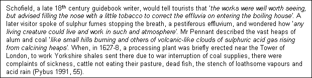
With increased competition from new works elsewhere in the country from 1766, the alum industry in Yorkshire began to decline, the last two remaining works, at Kettleness and Boulby, ceasing production in 1871. Attempts were made to try to improve the works by applying new technologies such as hydraulic engines and the use of alternative sulphates, or by the sale of by-products, such as Epsom salt, 'Roman Cement' and fossils (Pickles 2002, 17). 'Within 50 years of the last works closing down, nature had reclaimed her own, and there is now little trace above ground of one of England's first large-scale industries but the overgrown quarries and crumbling walls and steeping pits' (Pickles 2002, 17).
The sites of former alum works are still all capable of interpretation to a greater or lesser degree. Features survive in all of them to indicate something of what went on. 'The quarries are all fairly similar, being crescent shaped with a spoil-heap at one or both ends, a stream usually coming into the quarry over the top at one end and with a floor of at least two levels, boggy in places. Where there is a single quarry, the site of the alum house is often near by. With multiple quarries, a combined alum house will probably be some way from them all and in either case will be nearer to roads, a river or the sea than to the quarry. Investigation of field and house names in the vicinity will reveal such gems as 'kelp house', 'kiln garden', 'alum house yard' or 'slam gutter'. Study of the early OS maps will add revealing detail of the days towards the end of the industry. A moor top may reveal giant reservoirs of water now covered with heather. Discarded spoil and red burnt shale heaps still exist. Even an examination of the beach sand in some places will show that quite a high percentage of it is small particles of red shale from the alum works' (Pybus 1991, 55).
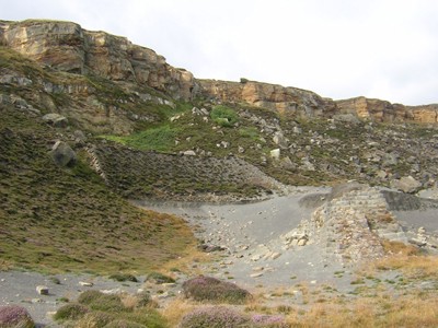
Figure 9.2. Remains of alum quarries at Boulby
Ironstone Works
The remains of ironstone workings can be found along the coast in this study area at Skinningrove, Staithes, Port Mulgrave, Staithes and Kettleness.
Typical historical components include:
- mines;
- quarries;
- bloom furnaces and slags;
- office and factory buildings;
- waste tips, dumps, and spoil heaps;
- associated transport systems (such as railways and harbours).
Iron ores are widely distributed throughout this area and scatterings of early bloom furnaces, have left traces of their slags throughout the region indicating that they have been worked since at least the Roman-British period (Owen 1986, 1). Along the coast the commercial ironstone seams also crop out from the sheer cliffs along the shore at various places. It was not until the early 19th century, however, that the Cleveland ironstone industry really took off.
Initially it was collected along the coast from the beaches and shipped to furnaces on Tyneside until 1825, when the Stockton and Darlington Railway opened up the Cleveland ironstones with its ability to handle large quantities of mineral traffic. The ironstone was shipped into the River Tees and transferred to the railway (Owen 1986, 6-8). Port Mulgrave harbour was built at Rosedale Wyke in 1857 in order to transport the ironstone mined here and was entirely dependent on sea transport for supplies of fuel and limestone, and for the dispensing of pig iron (ibid, 12-13).
The Cleveland Ironstone industry peaked in 1885 and by 1918 the Cleveland ore-field had been producing a third of the nation's ironstone for 40 years. The economic downturn that followed WW1 and later government policies led to the eventual decline of the ironstone industry, the last mine closing in 1968. Remains of these ironstone workings are still extant in many places along the cliffs and foreshore today. Groundwater from ironstone mines has also discoloured many of the streams in this area, such as those at Saltburn and Skinningrove (Figure 9.3) and serves as another reminder of this once flourishing industry.
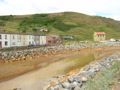
Figure 9.3. Skinningrove Beck discoloured by groundwater from the nearby ironstone mines
Jet Works
The remains of jet mining can be found along the coast in this study area at Loftus, Staithes, Runswick Bay, Kettleness, Lucky Dogs Point, Holms Grove, Stonecliff End, Overgate Cliff, Stoupe Bank, Rain Dale, and Goldsborough.
Typical historical components include:
- mines and adits (in both cliffs and foreshore);
- waste tips, dumps, and spoil heaps.
Jet is a type of fossilised wood, related to both coal and lignite, from an ancient tree similar to the modern araucaria or monkey-puzzle tree. Jet-bearing strata outcrop all along the high cliffs of the east coast from Robin Hood's Bay to Saltburn. At Whitby itself, the jet rocks lie under the sea from where fragments may be washed up on the beaches in the area (Muller 1991, 34).
Jet has been worked here from at least the Bronze Age to make amulets and jewellery (McMillan 1992, 6). The Romans and Vikings made great use of it too, making items such as jewellery, hair pins, spindle whorls and knife handles (Muller 1991, 35). It was not until the 19th century, however, that the jet industry boomed, with demand for jet ornaments increasing rapidly as a result of Queen Victoria's predilection for jet after Albert's death and as the 19th century progressed the ship building and whaling industries at Whitby were gradually replaced by a flourishing jet industry (Frank 2002, 11).

Jet was mined all over the North York Moors area (but not at Whitby). Adits were cut into cliffs and hillsides but no explosives could be used for fear of damaging the fragile substance. Sometimes the cliffs were terraced for greater safety. This was done at the Far Jetticks towards Robin Hood's Bay. Where the Jet Rock sank below the shoreline at high tide, it was possible at the right state of the tide to do a certain amount of underground mining (McMillan 1992, 20).
Figure 9.4. Whitby Jet Museum
The industry collapsed, however, as quickly as it had risen. Changing taste and supplies of cheaper substitutes such as vulcanite or glass attacked its economic base and by the early twentieth century the industry had dwindled. It is as a small craft industry, capable of meeting demand from the available supply of rough jet, that it survives today, although antique jet commands high prices (White 2004, 124). The jet industries heritage also attracts many visitors to the area, in particular Whitby (Figure 9.4).
At Great Broughton, in 'The Jet Miners' Inn' a poem reads: - Ah! Black as jet, but long ago In dignity and lace, The ladies wore around their necks A flash of ebon grace. But oh! To-day Great Broughton mourns, Still waves the merry corn, The beer flows at Jet Miners' Inn, But jet's no longer worn. Still fashions change, mayhap some day Again the craft will thrive, And Yorkshire jet will ring the earth, Black, flashing and alive. - (McMillan 1992, 20)
Potash and Salt Works
Potash was discovered in northeast England in 1939 in a borehole drilled by the D'Arcy Exploration Company to test for oil and gas (David Pybus pers comm). Potash is used worldwide in virtually every major agricultural industry. It is well suited for application as a fertilizer on grain crops such as corn, as well as soybeans, oil palms, coffee, sugar cane, cotton, fruit and vegetables. While the majority of potash production goes into fertilizer, it is also used in commercial and industrial products - everything from soap to television tubes. There is one potash mine operating in this study area, located at Boulby, opened by Cleveland Potash Ltd in 1973 (Figure 9.5). Potash occurs here at depths between 850m and 1,400m, the deepest workings in Britain.
Typical historical components include:
- mines and exploration boreholes;
- office and factory buildings;
- associated transport systems (such as railways, roads, ships and docks).
Potash is found within the sedimentary strata above the Permian evaporates in this area. The depth involved can prevent underground exploration and trial mining in some places.
To transport the potash, a ship/road/rail terminal was constructed at Tees Dock. The potash deposit is worked using a variation of a mining technique known as room and pillar: this system allows for areas to be extracted (rooms) leaving pillars to support the workings. Since 2003 a system for pumping tailings slurry into worked-out areas up to 1km from the core operation has also been in operation.
The ore is refined to separate potassium chloride from the salt. Following impact crushing and rod milling salt and impurities are removed by flotation while the overflow is classified and treated by flotation. Waste products include the discharging of clays and salt into the North Sea. The mine site at Boulby also produces salt for winter road maintenance and has recently been used as a suitable site for neutrino research.
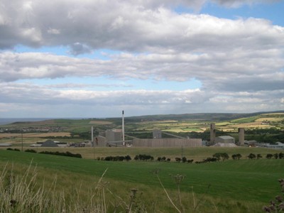
Figure 9.5. Cleveland Potash Mine, Boulby
Extraction of salt from seawater has taken place in this region from at least the medieval period. In Billingham salt making may have had very early origins as an ancient salter's track ran through this area, north to Wearmouth and south to Whitby. Salt exploitation was not specifically mentioned in documentary evidence for this area, however, until the year 1290 when a certain Robert de Brus (grandfather of Robert the Bruce King of Scotland) granted a salt pan in Hart village to Sir John Rumundebi. Large salt pans were used in the production of salt through the evaporation of sea water. The salt pan granted by De Brus may have been located at Cowpen near Billingham as this is known to have been an important centre of the salt making industry in the 14th century (Rowe 2000, 26).
An early account of salt making at Coatham near Redcar describes the working of salt pans:
"And as the Tyde comes in, yt bringeth a small wash sea-cole which is imployed to the makinge of salte, and the Fuell of the poore fisher Townes adjoininge; the oylie sulphurousness beinge mixed with the Salte of the Sea as yt floweth , and consequently hard to take fyre, or to keepe in longe without quenchinge, they have a Meanes, by makinge small vaults to passe under the hearthes, into which by foresetting the wynde with a board, they force yt to enter, and soe to serve insteede of a payre of bellowes, which they call in a proper worde of Art, a Blowecole." (Rowe 2000, 26)
The process of making salt was by perpetual boiling and reboiling (often up to eight times) of sea water in huge shallow salt pans made of lead. Salt making continued in the area in the later part of the fourteenth century. The local salt making industry achieved great heights in the 15th and 16th centuries when Greatham became a salt making centre and when 'Salt De Greatham' was famed throughout the land. By 1650 the centre of salt making in Britain had moved to South Shields. Large scale exploitation of salt did not return to Greatham until 1887 when the salt was extracted in the form of brine extracted from 1000 feet below the earth by Mr Casebourne, a cement manufacturer, boring for rock salt. Boreholes were also sunk at Marsh House Farm by the Hartlepool Salt Company by 1889. The salt here lay at a depth of about 900 feet in a bed 82 feet thick and was extracted as a brine solution and pumped to the surface. In 1894 the Greatham Salt and Brine Company by George Weddell were established and were later purchased by the famous salt-making company Cerebos in 1903. The extraction site at Marsh House Farm was recorded in 1993 by the Royal Commission on the Historic Monuments of England (Rowe 2000, 26).
Office and factory buildings were usually set up adjacent to the extraction sites and brine reservoirs were built. Although some buildings still remain, most are either disused or have been reused for other industrial purposes. Salt was exploited by brine pumping on the Teeside until 2002 and remains of these reservoirs and extraction sites can still be seen, but most works have completely vanished, apart from remains such as the concrete pads and steel pipe shaft heads of the brine pumps. Numerous salt-mounds resulting from the accumulation of ash and silt from boiling re-enforced brine also survive at Seaton Common, Greatham Creek and Salthome (Rowe 2000, 26).
Another chemical extracted from this area was magnesite. The magnesite works at Hartlepool are now being dismantled but were once used in the process of extracting magnesium from limestone by sea water process. The Plant, started in about 1937, played a role in World War II and then rapidly expanded after the war. During the war years it was used for aircraft components and incendiary bombs - train-loads of lime were brought into the plant and mixed with the magnesium. Situated here on the Hartlepool coast meant it was close to the sea for the extraction of the magnesium as well as being on train lines for limestone delivery. The export of the purified magnesium was also then handled by the trains for use in making the aircraft and incendiary bombs.
Anhydrite, also known as dry gypsum, was also extracted at Billingham in the 1920s and 1930's, for use in the production of fertilisers. The mine at Billingham was 700ft deep and consisted of miles of grid-like subterranean streets.
Stone Quarries
The remains of disused stone quarry workings can be found along the coast in this study area at Preston-on-Tees, Loftus, Staithes, Robin Hood's Bay and Ravenscar.
Typical historical components include:
- quarries and pits
- waste tips, dumps, and spoil heaps
- associated transport systems (such as railways, roads, ships and docks)
Another of North Yorkshire's most significant exports was stone for building, in particular sandstones. As well as being workable this stone had the virtue of hardening as it weathered and of resisting the effects of immersion, so it was useful in harbour works. It is mainly found in and around Whitby and was used to construct most of Whitby Abbey. Possible early sources are quarries on the cliff edge above The Scar and in the Abbey House area.
'One of the main sources for sandstone, however, was Aislaby, three miles to the south west of Whitby. The quarry here has recently been re-opened, but in its day its products were sent from Whitby to build Margate and Ramsgate piers, the foundations of London and Waterloo bridges, Covent Garden market and London Docks, to quote just a few examples. Whitby piers were built from the same stone. These blocks, like all those that came from the quarry to the stone wharf in the upper harbour, were carried on wagons pulled by oxen. In 1834 a Whitby Stone Company was formed, with its wharf at Boghall. It was a product from cuttings for the new railway to Pickering, the works for which had uncovered many different building stones; these were brought down by inclined plane from the quarries at Lease Rigg and thence by rail to Whitby for shipment' (White 2004, 132).
The local magnesium limestone has also been exploited for use as a building stone and as a lime mortar. Quarrying of limestone appears to have started quite early, particularly in Hartlepool, with many of the quarries already abandoned at the time of the 1st edition (1856-61) OS survey. Some quarries in use in the 1850s had already gone out of use by the 1890s. Others continued to prosper and some, such as Hart Quarry, are still in use today for extracting dolomite aggregate. Limestone from the excavation of the docks at Hartlepool was also used for building purposes (Rowe 2000, 24).
Sand and gravel extraction is another local industry, but is perhaps the most poorly documented. This is not surprising as extraction of local glacial sand and gravel requires no particular engineering and can be simply dug open cast from small shallow quarries. In most cases the quarries themselves were small circular pits less than 20 metres in diameter. They are often sited on cliffs away from the towns (eg Widdy Head and Raindale Slack) suggesting that they were exploited by individual farmsteads for local construction needs. In most cases the pits have been backfilled and taken back into agriculture. It is interesting to note that the pits often show on aerial photographs and have in fact been misinterpreted as prehistoric or later enclosures. Larger, and potentially more industrial scale pits, have been noted at Newton Bewley and Claxton (Rowe 2000, 26).
Values and Perceptions
Complex feelings are generated by industrial remains, to a great extent dependent on people's closeness (in terms of both space and time) to the industries. For many they are reminders of past employment and great days in North Yorkshire's history, when it was the hub of British alum quarrying, ironstone and jet mining.
Many are still inspired by the remains: industrial history and archaeology are rapidly growing interests in North Yorkshire. Indeed many of them now have designated status that protects them to varying degrees.
Research, amenity and education
Although industrial archaeology has dominated the study of the post-medieval period, archaeological recording (survey and excavation) has only recently been applied in a systematic way to 19th and 20th century industrial sites and landscapes in North Yorkshire and the potential for discovering important features, recording, interpreting and presenting them is considerable (Petts and Gerrard 2006, 189).
Archaeological recording (survey and excavation) has only recently been applied in a systematic way to industrial sites and landscapes in North Yorkshire and the potential for discovering important features, recording, interpreting and presenting them is considerable. Sites at Boulby and Peak have undergone long-term archaeological excavation and, through work by the National Trust, consolidation, helping in the elucidation of this complex process (White 2004, 126). Loftus and Kettleness works have been extensively surveyed by English Heritage (together with some of the inland works). Individual complexes can be researched in great detail and there remains much to be done in terms of documenting particular works.
Most histories have as yet been technical or economic (e.g. mine yields). More work could be done on the social background of North Yorkshire extractive industries, in both the medieval and modern periods.
Industrial 'heritage' is a rapidly expanding element of the North Yorkshire tourism industry. It needs to be handled relatively well as the sites are potentially hazardous and competent and responsible people should be involved. Education is involving children more in their area's industrial past and this process will only continue to increase with bodies like The North York Moors National Park, local authorities and the National Trust all engaged in promoting the presentation of industrial monuments and landscapes.
Condition & forces for change
All the relict industries in this area, such as alum quarries, ironstone and jet mines, are now disused, but many are still visible in the landscape today, although most have now become overgrown by scrub and woodland or are now barely distinguishable from the natural areas of the rocky foreshore.
Condition varies considerably. Some sites have been almost entirely destroyed, others are virtually intact, left with most features except equipment still in place (eg Sandsend and Boulby Alum quarries), but most have seen some depredation, usually before North Yorkshire entered the post-industrial age and these features were recognised as meaningful by people living beyond their immediate neighbourhood.
In some areas, such as cliffs and rocky foreshores, industrial complexes from the medieval period or beyond can survive in excellent condition. Elsewhere, derelict land has been gradually tidied-up by farmers or expanding housing developments and in certain areas the remains of early industry have been either damaged or destroyed by cliff falls or by later or still active workings.
Where a complex survives well then so does its internal coherence. Being very mechanistic, extractive industry sites can be disentangled so that each element can be seen in relation to others. When elements have been removed the whole pattern can, however, be difficult to understand. Decay of structures will continue apace if they are not consolidated. Active sites continue to expand, while there remain commercially viable markets for their products.
Extractive industry (minerals) remains form some of the most distinctive landscapes along the North Yorkshire coastline, including the spectacular cliff alum workings, as well as the many semi-derelict or overgrown industrial buildings, yards, lanes, and tramways. 'The effect of this heavy industrialisation is often so great that in some cases we may not even recognise the magnitude of the scale. Whole cliffs have been changed beyond recognition. Access ways to the shore and landing places have altered the shape of the coastline. At Ravenscar, for example, the former alum works are intercut by a railway line, a brickworks, and an inclined plain from a ganister quarry on the moor above, all confused by landslips and coastal erosion' (White 2004, 122).
In addition the more indirect effects extractive industry has had are often not appreciated, such as the development of certain towns, and the generation of wealth.
Rarity and vulnerability
In terms of rarity, extractive industries (minerals) can, of course, exist only where their resource lies. Jet mines and alum works are nationally confined to North Yorkshire whereas ironstone mines can be found in other parts of Britain.
Continually rising awareness of the value and importance of industrial remains will make them increasingly less vulnerable. Many sites are now designated areas, especially AONBs and SSSIs (mainly the cliff sites).
Many of the surviving alum working sites are regarded as of national importance, both in terms of helping to understand the development of the industry and to protect the most important remains (Lee 2002, xi).
Natural recolonisation of chalk and limestone quarries has led to the development of attractive and species-rich communities in many parts of the United Kingdom. These communities have a basic similarity in floristic composition wherever they occur, but they also show a great deal of individual variation resulting from differences in the location, history and variability of the quarry itself and in the nature of the surrounding habitats. The interest of old quarries may be enhanced by the presence of individually rare or local species and especially by their refuge status in relation to the loss of semi-natural calcareous grassland in the district. It is suggested that some sites play an important role in wildlife conservation and that this factor should be considered in any programme of land reclamation (Davis, 1979). Indeed many such quarries have now been designated as SSSIs by virtue of this.
Recommendations
Grants for consolidation and presentation should be encouraged. Statutory protection of the most important sites and complexes should be extended. Archaeological recording and historical research will help raise the sites' profile within local communities. Developers, working in partnership with English Heritage, County Councils and Archaeological Research Services, should be encouraged to make provision, prior to carrying out work, for archaeological investigation work to be undertaken.
As in other regions, the archaeology of ironstone mining of all periods remains seriously under-recorded, and in many cases has probably gone unrecognised. The potential for finding any early mining remains should be a priority for development control in any applications within historic iron mining areas, and for archaeological recording of any sites/landscapes where its existence is suspected (Petts and Gerrard 2006, 223).
Sources
Publications:
Berg T and Berg P (trans) 2001. RR Angerstein's Illustrated Travel Diary, 1753-1755: Industry in England and Wales from a Swedish Perspective. Science Museum,
Buglass, J, 2002. The Survey of Coastal Transport in the Alum Industry, in I Miller, 2002
Herring P, 1998. Cornwall's Historic LandscapeM. Cornwall Archaeological Unit, Truro
McMillan, M. 1992. Whitby Jet Through The Years.
Miller, I, 2002. Steeped in History. The Alum Industry of North East Yorkshire, Oxford Archaeology North
Owen, J S, 1986. Cleveland Ironstone Mining.
Petts, D and Gerrard, C, 2006. Shared Vision. The North East Regional Research Framework for the Historic Environment. Durham County Council
Pybus, D, 1991. Alum and the Yorkshire Coast, in Lewis, D (ed) 1991, The Yorkshire Coast, 46-59
Rowe, P, 2000. Industrial Archaeology in Hartlepool. Tees Archaeology,
White, A, 2004. A History of Whitby. Phillimore, Bodmin
Websites:
http://www.pancrack.tv/subject.html
http://www.yorkshirefilmarchive.com/view.aspx?id=37
http://www.bgs.ac.uk/mineralsuk/home.html
http://www.northeastengland.talktalk.net/page88.htm
