
England's Historic Seascapes: Scarborough to Hartlepool
Cornwall Council, 2007. https://doi.org/10.5284/1000201. How to cite using this DOI
Data copyright © Historic England unless otherwise stated
This work is licensed under the ADS Terms of Use and Access.


Primary contact
Charlie
Johns
Cornwall Council
Kennall Building, Old County Hall
Station Road
Truro
TR1 3AY
UK
Tel: 01872 322056
Resource identifiers
- ADS Collection: 744
- ALSF Project Number: 4731
- DOI:https://doi.org/10.5284/1000201
- How to cite using this DOI
Introduction | Seascapes Character Types
Navigation Hazard
- Introduction: defining/distinguishing attributes and principal locations
- Historical processes; components, features and variability
- Values and perceptions
- Research, amenity and education
- Condition & forces for change
- Rarity and vulnerability
- Sources
Introduction: defining/distinguishing attributes and principal locations
The Type Navigation Hazards includes the following sub-types:
- Caution Areas (bars, shoals, sand banks, scars and scarps, drying areas);
- Obstructions (including exposed rocky coastlines with rocky outcrops, under water/awash rocks, maritime debris, fisherman's fasteners);
- Dangerous wreck clusters and non-dangerous wreck clusters (vessels or aircraft);
- Natural marine conditions (areas of heavy swell and breaking waves, prevailing winds).
Historic navigation hazards are difficult to map with any precision although essentially this is the purpose of nautical and maritime charts. Major navigation hazards have figured on the earliest Admiralty charts and are mentioned in sailing directions for the North East. Earlier charts obviously contain less detail and use less accurate survey methods to record features instead tending to depict those hazards that mariners most need to be aware of and which are most easily identifiable. Modern charts depict far more information and are a valuable source of mapping.
As with Type Maritime Safety the majority of the features associated with this Type are typically found on or immediately adjacent to the coast, although wrecks can be found throughout the study area. Historically the rocky North Yorkshire coast and the Tees Estuary have been notoriously dangerous areas to navigate, especially given the few and far between places of refuge. The submerged scaurs and awash-rocks that are strewn along the foreshore and inter-tidal areas, and the shoals, sandbanks and drying areas associated with the estuary are all exacerbated by the tempestuous nature of the North Sea itself. Often problems were associated with strong easterly winds driving waves and sediment onshore creating bars that obstructed harbours, rivers and other access points alike.
Areas of natural swell are associated with shallow waters, particularly over rocks as at Whitby (Figure 9.41), or are found over the surface of the top of The Dogger Bank, in depths of 10m or so.
Historical processes; components, features and variability
Mariners have been faced with the unfavourable and often treacherous conditions of the North Sea since prehistory. As a result of the relatively limited nautical knowledge and means of navigation, maritime activities in this region focused on coastal navigation.
As urbanisation and trade increased through the Medieval to Early Modern periods the southern part of the North Sea evolved into the busiest maritime area in the world. Consequently in comparison with other regions quite a high number of vessels have been lost in this area (Figure 9.42). Over 3000 known wrecks, including almost 20 aircraft, have been recorded in the study area, the majority within 12 miles (19.3km) of the coast. The wrecks that fall within 10m of water have been generically categorised as dangerous as they present a greater threat to current shipping and fishing vessels than those in deeper waters. The majority of wrecks are recorded from the 18th century onwards and this is probably due to the better survival and materials used. Earlier vessels may be present but the lack of documentary sources, such as Lloyd's Register, makes it difficult to assess. Undoubtedly however there is archaeological potential for craft from prehistory and the medieval periods being found in the area. Survival also depends largely on localised marine conditions, whether the site is covered, scoured or damaged by other activities such as trawling, anchors dragging or interference from divers and others. More ephemerally distributions of artefacts lost or thrown overboard can indicate anchorages, shipping routes or battle sites.
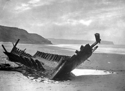
Figure 9.42. Wrecked fishing vessel on Whitby Beach (© Whitby Museum)
Historically the Tees Estuary and River were particularly hazardous. Even after Trinity House had marked the approaches of the Tees with wooden buoys in the early 16th century, it was very difficult to establish the correct deep water channel. At least three navigable channels are known from historic UKHO charts and it was the changing nature and locations of these that presented sailors with their greatest problems. The situation was compounded/caused by an extensive bar, seven miles long, running from Hartlepool to Redcar, two miles (3.2km) out into Tees Bay. The extent of this bar varied considerably according to weather conditions and the whole character of the Tees would change as a result of prevailing strong winds. Easterly winds tended to raise the level of the bar causing the depth of water at the bar to vary, although the average at low water spring tides was about 8 or 9 feet (2.4 - 2.7m). Dramatic changes to the very course of the channel both up to and over the bar, took place throughout the centuries (Le Guillou 1975, 1).
Before the Tees was dredged, to reach Stockton or Yarm, both important Medieval ports, vessels had to proceed slowly up river; as there was no clear or unobstructed channel and extensive deposits of sand and stones occurred frequently in depths of water as shallow as two feet (0.6m). Groups of "trackers" were often used to tow vessels through the Mandale Bottoms, a three-miles-long (4.8km) stretch of the river shaped like a horseshoe. Because of the very uncertain nature of the river at this section, larger vessels found it preferable to unload their cargoes at the warehouses built at Cargo Fleet, present day Middlesbrough (Le Guillou 1975, 3). The place name element fleet is likely to refer to fleets of cargo ships coming up the river to moor here.
'Between Hartlepool and the Tees lies a dangerous rock called the Long-scars, close by the Shore; come no nearer than five or six Fathom Water. A League and a half from the Tees lies Hartlepool, upon a Point lying out almost like an island; the Harbour lieth in a Bight to the Southward of the Town, within a Head which is dry at low water'
The English Pilot of Northern Navigation, 1752 (sailing directions) (Whitby Museum)
Dredging in the 1850s resulted in a small increase in river depths, but the major obstacles were removed in the 1870s, especially the 8th and the 9th buoy scarps. The former obstacle was described as 'a rock of lias which lay across the river, and formed a bar, stopping the influx of the flood and obstructing the ebb'. Clay was dredged from the scarp area in 1873 but in the following year rock boring machinery was used at times of low water (Le Guillou 1975, 40).
'To sail into Hartlepool: About two Leagues to the Northward of Hartlepool lie two Rocks about a mile from the Shore, the greatest called the Dogger, shews like the Bottom of a Vessel, always above Water: the other called the Boot is less, and hath seven Feet upon it at low Water.' The English Pilot of Northern Navigation, 1752 (sailing directions) (Whitby Museum)
Further south landing a coble at Robin Hood's Bay was particularly hazardous. The boat had to be steered along a submerged channel with rocks on each side. Posts were used as marks. However, because of the headland, Bay Ness or North Cheek, it was sometimes possible to land at Robin Hood's Bay when Whitby was stormbound. There was no harbour at Robin Hood's Bay, and, except in very fine weather, boats had to be dragged up the slipway onto dry land (Frank 2002, 88).
At Whitby the physical obstacle which loomed largest in the fears of fisherfolk was the harbour bar. In a northerly or easterly gale it is still one of the most dangerous hazards on the east coast, even though the channel is nowadays dredged regularly. In the early 1900s however, it was silted up to such an extent that, 'we used to row in - maybe an hour's flood - and we used to touch the sand with our oars'. For the fishermen in their cobles, and for their families on shore, the bar came to dominate their lives:
'In them days there was no Extensions; there was only the lighthouses, the two piers, and it was all open sea. It was allus the danger zone. They never bothered if they got ower t'Bar. They allus called it: 'I wish they were ower t'Bar'. Ower there, and then they were all right, because it usedt o break and swamp them.'
A contributory factor to Whitby's decline as a fishing port was the state of the harbour. So bad was it at times that 'vast deposits of sand and mud impeded the channel, making it sometimes impossible for fishing boats to reach the quays and discharge their cargoes'. In March 1900, the Dock End (the usual landing place for herrings), was described as a 'stinking cess pool, and a very great eyesore' (Frank 2002, 36-7).
To sail into Whitby:
'There is a Rock lies off Whitby, called Whitby Rock, (or by some Whitby Chambers,) the Marks to avoid it going to the Northwards of it, are to bring Whitby Steeple open to the Northward of the South Point of the Harbour; and to run along by it, you must keep the South Point of Robin Hood's Bay clear off the Land of Whitby.
From Whitby to the Tees, the Coast lieth WNW and W by N, about seven Leagues; between them both lie Huntcliff-Foot and Rock-cliff; Hunt-cliff Foot is a high Hill lying on the Sea-Side about 4 Leagues to the Eastward of the Tees. Next to that is Red Care, it is a Cliff of such red Earth, that when the Sun shines against it, it sheweth like a red Cloth; there are two very good Marks to know the Coast by. Close to the Southward of the Mouth of the Tees lie three Ledges of Rocks, called the Salt-Scars, about half a League ENE into the Sea, which are very foul and stony, and are dry at low Water: Upon the North-Side they are very flat, so that you may sound them in five, six, or seven Fathom; but on the South-Side are so steep, that coming near to them and sounding in 13 or 14 Fathom you shall be upon them before you can heave the Lead again.'
The English Pilot of Northern Navigation, 1752 (sailing directions) (Whitby Museum)
Values and Perceptions
Navigation hazards are readily perceived to those who know. They loom large in people's consciousness due to the danger associated with them. Often unfortunate tales and myths will cling to these areas like flotsam and jetsam evoking old rhymes and song.
In an ironic way the whole creation, maintenance and draughting of Admiralty Charts and other navigation devices has been due to the hazards and dangers of the sea. It is about what to miss rather than where necessarily to sail, this is epitomised by the use of Chart Datum (as opposed to Ordnance Datum) as the reference for all soundings, which is the lowest depth of water.
Research, amenity and education
Current research undertaken by Bournemouth University, 'Mapping Navigational Hazards as Areas of Marine Archaeological Potential' (commissioned by English Heritage, funded by ALSF) offers a methodology for identifying and mapping areas of maritime archaeological potential, specifically where high potential for shipwreck losses coincide with areas of high preservation potential (Merritt et al, 2006).
Boat anglers have an obvious reason to be interested in shipwrecks, because fish are usually found in heavy concentrations around large wreck-sites. The seabed in general has huge vast plains of rather flat featureless submarine scenery and any large stationary object such as a wreck, provides shelter, food and protection for many various species of fish (Young 2000, 10). Indeed wrecks are often seen as beneficial sites of increased biodiversity by marine ecologists.
Shipwrecks attract divers for a multitude of reasons. Those usually found in depths of more than 60m are usually beyond the reach of most amateur sport-divers (Young 2000, 10). Wrecks have the most obvious educational potential as they represent the most iconic use and dangers of the sea. Although largely prosaic in their loss they nevertheless conjure up evocative images of adventure, piracy and Davy Jones' locker.
Condition & forces for change
Many thousands of vessels have come to an untimely end along this part of north-east coastline over the past few centuries. However, until the late 1800s, the vast majority were built of wood and usually disintegrated within hours of sinking (Young 2000, 11). Most wrecks surviving today will be constructed of hard woods or metal. Many are only known from documentary references. Prevalent marine conditions will also affect the degree of survival especially the covering by sediments or scouring by currents.
Natural hazards such as banks, shoals, rocky outcrops, etc, are subject wholly to natural erosional processes although the rate and extent may be influenced by man-made activities or constructions that change the normal marine conditions. The changing nature of sand banks and shoals means that archaeological material may be covered or embedded within such bedforms and may only be revealed before naturally uncovered by seismic survey.
Sea dredging and beam trawling may impact upon known seabed obstructions and unknown wrecks. This would take the form of both direct damage to wreck structure contents and setting, and the destabilisation of sites resulting in renewed corrosion and decay. There is also some potential for impact upon discrete items of ship-borne debris. Encounters with wreck material are likely to damage suction gear and/or contaminate the dredged material, however, not much of this happens along the coast (Wessex Archaeology, 2002).
In 2000 a joint initiative was launched to help raise awareness of the issues surrounding wreck diving in the UK and to ensure the best possible wreck diving practices are observed by recreational divers. The awareness campaign itself was the culmination of many years' work with other interested parties, including the Maritime and Coastguard Agency, Ministry of Defence and archaeological groups (including the Nautical Archaeology Society and the Joint Nautical Archaeology Policy Committee), to clarify the issues and find ways to disseminate information.
Rarity and vulnerability
Wrecks are numerous in the waters off the Tees and North Yorkshire coasts. Most derive from the early-modern period (1750-1900) of coastal trade and fishing. Further offshore they become increasingly dispersed although clusters occur in some areas over foul grounds and off the Dogger Bank in particular.
Within the context of the Merchant Shipping Act 1995 'wreck' refers to 'flotsam, jetsam, derelict and lagan found in or on the shores of the sea or any tidal water. It includes ship, aircraft or hovercraft, parts of these, their cargo or equipment. It may be of antique or archaeological value such as gold coins, or a yacht or dingy abandoned at sea, or items such as drums of chemicals or crates of foodstuffs' (Definition from the Receiver of Wreck).
Under the Protection of Military Remains Act 1986, shipwrecks and all aircraft that have crashed in military service were designated as war graves and imposes restrictions on their exploration and marine salvage. The Ministry of Defence (MoD) has powers to protect vessels that were in military service when they were wrecked. The MoD can designate named vessels as 'protected places' even if the position of the wreck is unknown.
Recommendations
Navigation hazards, whether natural or man-made represent an important archaeological resource. There may be a link between the occurrence of natural obstacles and the presence of wrecked craft, lost gear or accumulated archaeological deposits. Local sedimentary conditions will also indicate whether there is preservation potential for materials.
The known and potential archaeological resource of ship and aircraft wrecks, and other forms of historic maritime material, as identified by the prior desk-based studies require corroboration by data derived from geophysical and geotechnical surveys. Side-scan sonar surveying is the pre-eminent method for identifying wrecks (Wessex Archaeology, 2007). Recent initiatives such as the 'North-East England Maritime Archaeology Research Archive will provide a basis for the deposition of any new information.
Since most of the known wrecks from this region are of post-medieval date or later, any medieval wrecks identified should be the focus of detailed recording (Petts and Gerrard 2006, 201).
Sources
Frank, P, 2002. Yorkshire Fisherfolk. Phillimore, Bodmin
Le Guillou, M, 1975. A History of the River Tees.
Merritt, O D, Parham D and McElvogue, DM, 2006. Enhancing our understanding of the marine historic environment: Mapping Navigational Hazards as Areas of Maritime Archaeological Potential. Bournemouth University.
Petts, D and Gerrard, C, 2006. Share Visions: The North-East Regional Research Framework for the Historic Environment. Durham County Council
The English Pilot of Northern Navigation, 1752 (sailing directions) (Whitby Museum)
Wessex Archaeology, 2002. Area 466 North West Rough. Archaeological Assessment: Technical report.
Wessex Archaeology, 2007. Historic Environment Guidance for the Offshore Renewable Energy Sector. Prepared for COWRIE.
Young, R, 2000. The Comprehensive Guide to Shipwrecks of the North East Coast. Volume 1 (1740-1917).
