
England's Historic Seascapes: Scarborough to Hartlepool
Cornwall Council, 2007. https://doi.org/10.5284/1000201. How to cite using this DOI
Data copyright © Historic England unless otherwise stated
This work is licensed under the ADS Terms of Use and Access.


Primary contact
Charlie
Johns
Cornwall Council
Kennall Building, Old County Hall
Station Road
Truro
TR1 3AY
UK
Tel: 01872 322056
Resource identifiers
- ADS Collection: 744
- ALSF Project Number: 4731
- DOI:https://doi.org/10.5284/1000201
- How to cite using this DOI
Introduction | Seascapes Character Types
Port
- Introduction: defining/distinguishing attributes and principal locations
- Historical processes; components, features and variability
- Values and perceptions
- Research, amenity and education
- Condition & forces for change
- Rarity and vulnerability
- Sources
Introduction: defining/distinguishing attributes and principal locations
The Type Port includes the following sub-types:
- Port administration and regulation areas;
- Landing places;
- Piers;
- Quays.
Components of this Type include:
- landing stages, wharfs, jetties, pontoons, slipways, terminals;
- cargo-handling equipment, storage facilities;
- custom areas, quarantine areas;
- pilot stations, small craft facilities;
- wrecks;
- lighthouses, batteries;
- associated transport systems (such as railways, roads, tramways).
A port is a facility for receiving ships and transferring cargo to and from them. Some ports, such as Scarborough or Whitby, have facilities particularly suitable for landing and distributing fish. Often processing facilities will be located very close by. Harbour pilots, barges and tugboats are frequently used to safely manoeuvre large ships in tight quarters as they approach and leave ports. The presence of deep water in channels or berths, the provision of protection from the wind, waves and storm surges and access to intermodal transportation such as trains or trucks are critical to the functioning of ports.
Principal port locations within this study area today include Hartlepool, Tees, Whitby and Scarborough. Remains of specialised port facilities are also found at Skinningrove and Port Mulgrave.
The more modern ports are much more compact than the historical ports. The administrative area of Newcastle extended to include the port of Whitby. The port of Whitby extended from Saltburn to Peasholm (just north of Scarborough). The adjacent port of Scarborough was part of the port of Hull (Pybus Pers Com).
Historical processes; components, features and variability
'As settlement and centralized political control became more established in the 7th and 8th centuries, the first English towns began to appear, and a significant number of them were sea and river ports' (Friel 2003, 25). The growth of ports was not just occurring in England: ports, of course, had to trade with other ports in order to grow and this period is marked by the development of settlements on both sides of the North Sea and English Channel, with the Germanic word-element wic, meaning 'trading place', incorporated into their names (eg Runswick and Saltwick, as well as Lundenwic (London), Eorforwic (York)). On the other side of the sea these included Sliaswich (Schleswig, now in Germany), and Wijk-bii-Duurstede (at the mouth of the Rhine in Holland). All were either sited on navigable rivers or in good coastal harbours. A wic or wyke is also a place on the shoreline where a boat can be landed and there is a way up from the beach. However, not all port names incorporated the wic element and coin finds scattered around the coast suggest that trading went on in all sorts of places (Friel 2003, 25-6).
During the 8th century sea trade, and the prosperity that went with it, operated as a major engine of economic growth in England. The growth of ports was generally stimulated deliberately by local rulers and from the earliest times, it seems, government was involved in trade in some way. The link between trade and wealth underpinned its regulation and protection' (Friel 2003, 27).
Customs are the duties, tolls, or imposts imposed by the sovereign law of a country on imports or exports and are enforced by customs agencies, establishments, or procedures. The accounting entities of medieval English customs ports were based around a major head port and its creeks or lesser ports where trade revenue was collected. Custom ports' administrative authority often encompassed large areas, for example the customs port of Newcastle stretched as far as Whitby (Friel 2003, 71). By about 1000 the English government had developed a relatively complex list of harbour dues charged on merchandise reaching ports. Foreign merchants also paid dues according to where they came from (ibid).
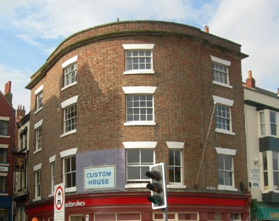
Figure 9.17. Former custom house, Scarborough
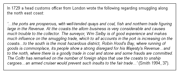
Imposition of customs duties also gave rise to smuggling. The term itself is thought to have derived from either the early English word smuckle or the Scandinavian word smuggla, both of which mean 'to hide' or 'to creep'. Throughout the 18th and early 19th centuries this black economy flourished as a constituent part of everyday life along this north east coast. Luxury goods which attracted high rates of duty, such as spirits, silks and tobacco, found a ready market in the towns and ports in this area. Smuggling activities were as individual as the ports and harbours in which they developed, dependent on trade patterns, coastal traffic and the areas they serviced (Smith 1994, 8). Cobles, the traditional fishing boats of the Yorkshire coast, were renowned for their use in smuggling. During the heyday of smuggling there were hundreds of cobles sailing the inshore waters from every port, harbour or bay and most were involved in the smuggling trade (Smith 1994, 37).
Quays or wharfs (structures built along or at an angle from the shore of navigable waters) were necessary components of ports that enabled ships to lie alongside them to receive and discharge cargo and passengers. Wharves along rivers were generally served by craft small enough to get through the bridge arches carrying coastal shipments or cargos off-loaded from bigger ships. 'Creeping waterfronts' often formed, as silt and rubbish build up against the waterfront and it became difficult for larger vessels to tie up, so that a new quay had to be built further out into the water in order to provide sufficient depth of water.
The names of some of the quays and wharfs, such as Fish Wharf, advertised some of the commodities that passed through them. Medieval cargo-handling in most ports was rudimentary. Most unloading was probably handled using blocks and tackles attached to a ship's yardarm, or by porters (the forerunners of dockers) tramping up and down gangways. It is apparent that most medieval ports were little more than creeks, too small and too poor to be able to afford or need harbour facilities. If ports could grow, they could also die. Sometimes physical factors were the cause, such as silting up of estuaries, storms and flood damage. Some ports were killed by the actions of men, by acts such as wars, raiding, and abandonment (Friel 2003, 70-71).
Piers also form essential components of ports, for use as landing places, promenades or to protect or form a harbour. Piers range in size and complexity from a simple lightweight wooden structure to major structures extended over a mile out to sea. Lightweight piers are supported by widely spread piles or pillars allow tides and currents to flow almost unhindered, whereas the more solid foundations of a quay or the closely-spaced piles of a wharf can act as breakwaters, and are consequently more liable to silting. The term pier is principally associated with the image of a Victorian cast iron pleasure pier but many also function as port landing places and as harbour breakwaters.
In the 11th and 12th centuries, vessels of small enough draught could go to the ports of Coatham, Billingham or Portrack - 'the harbour of trading vessels' (Le Guillou 1975, 2). Yarm had become the principal port of the Tees by the 12th century. In 1400 a bridge was built there and remained the lowest crossing point for next 400 years (Le Guillou 1975, 2-3). 'By the mid-17th century Stockton had become the most important port, surpassing Yarm and even Hartlepool, with the Customs House being moved there from Hartlepool. Access to agricultural and industrial (especially Dales' lead) hinterlands gave it an advantage over other coastal ports. The principal trade was English coasting which continued throughout first quarter of the 18th century, but there was also growing importance as a port for foreign trade with Baltic and Low Countries. By the mid-18th century Stockton was firmly established as the leading port of the north-east after Hull but was already beginning to feel the adverse affects of the river's shortcomings, in particular the problems of navigation. Dales' lead was again being directed toward York and Hull and products from Lake District counties were going to Newcastle for shipment' (Le Guillou 1975, 6-9). There were a number of smaller ports that were also used such as Coatham, Dabholme, Cargo Fleet (Caldecoates), Portrack, Newport and Billingham. As many of the larger ships could not get up the river goods were transferred to smaller ships at these ports.
The port at Hartlepool (Figure 9.18) has been important since the medieval period, when the Bishop of Durham used it to import his supplies of food and wine. But the harbour fell into serious disrepair and silted up, even having crops grown on it. Its importance as a port increased again with the Industrial Revolution at the end of the 18th century, when there was an increased demand for coal. There were collieries a few kilometres inland from Hartlepool and the coal had to be carried from the collieries to ships at Stockton-on-Tees, and then taken to London. In 1833 a railway was constructed at Port Clarence, to the south of Hartlepool. This enabled coal to be transported more easily to Hartlepool and a new harbour was soon built, opening in 1835. By 1850 there were eighteen collieries shipping coal from Hartlepool. The channel into the harbour had a tendency to silt up, however, and so many improvements such as dredging and repairs to the piers were required over the years. In 1862 the port at Hartlepool was ranked as England's fourth largest port, after London, Liverpool and Hull (Rowe 2000, 10).
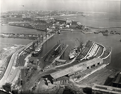
Figure 9.18. Hartlepool Harbour and Docks (1960) (© Hartlepool Arts & Museum Service)
The harbour at Whitby naturally divides into an upper and a lower half. The upper harbour was used as a safer anchorage in storms, for laying up ships over winter and for shipbuilding. The lower harbour (Figure 9.19) was not a safe mooring before the present piers were completed because of the deep swell that could enter the harbour. In good weather much shipping would lie off Whitby Roads, the area to the west of the harbour mouth, waiting for the tide. Especially deep-laden vessels could also lie here awaiting unloading into lighters. Nevertheless the lower harbour was satisfactory in good weather and was used by many fishing boats. In the upper harbour two large mud banks, High and Low Bell, were exposed at half ebb. However, recent changes in the harbour and the building of new wharves have rearranged the channel of the Esk and moved the mud banks around. A considerable tract of land has been recovered from the harbour over the last two centuries and buildings and car parks now cover the former Walker and Langborne Sands at the end of Bagdale, where shipbuilders once worked. Fish were generally landed from fishing boats onto various staithes rather than quays. Whitby Stone Company had a wharf near Bog Hall for the convenience of loading its heavy cargos and there was some quayage on the east bank of the river above the bridge, but otherwise Whitby's shipping acted as a carrier between other ports, putting in at Whitby only for repairs or laying up. A succession of piers have been built here since the 16th century as an attempt to protect the harbour from north-westerly gales, to reduce swell and to prevent the blockage of the river mouth by the longshore drift of sand. Even today, however, the harbour needs constant dredging to maintain the deep water channel (White 1993, 46).
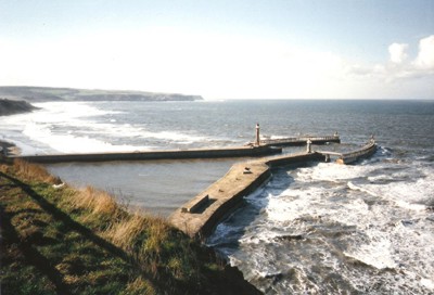
Figure 9.19. Whitby Harbour (© Dave Hooley)
One of the main components of the development of shipping and shipbuilding at Whitby is the administrative boundaries that run along the middle of the river; the west side of Whitby is actually in the township of Ruswarp, while much of the eastern side is in the township of Whitby and under a much more restrictive regime initially regulated by the abbey and after the Reformation by the lord of the manor. The burgess pier (on the east side of Whitby) was constructed in medieval times but the burgesses were constrained by the abbot and never flourished. Latterly the lord of the manor imposed higher shipbuilding and port dues and hence much of the development of the port of Whitby was not in Whitby in what is now known as the west side of Whitby where dues were significantly lower or absent. The acts of parliament for the construction of piers at Whitby are more numerous than those of Scarborough and give valuable insights into the development of the port (Pybus Pers Com).
The history of Scarborough's harbour can be traced back to at least the medieval times, and is 'a history of an almost constant struggle to improve and maintain the quays and piers, which are vulnerable to attack by sea and to decay' (Waters 2005, 28). Henry III granted Scarborough the right to construct a new port 'with timber and stone' in 1252 (ibid). Ships could then safely sail in and out at both low and high water. The harbour was paid for by tolls, or quayage, imposed upon both sea-borne trade and fishing. The once flourishing import and export trade at Scarborough saw groceries coming from London and coal from Newcastle, while ships from the Baltic brought timber and cloth. Wines and spirits arrived from other continental ports. Some of Scarborough's chief exports included farm produce and salted fish (ibid).
Recent excavations at Scarborough have uncovered evidence of the medieval harbour area. Domestic refuse was deliberately dumped to consolidate land behind the quay. This helped support the quay wall, protecting Scarborough's early waterfront from the North Sea tides, and allowed land to be gradually reclaimed from the sea's grasp for building. Mooring rings have also been found in the basements of properties along Quay Street, suggesting the location of an earlier harbour. The Old Pier was rebuilt in 1565 but very little was improved in the harbour until the 1700s, when Acts of Parliament paved the way for major construction. Today, although Scarborough still functions as a fishing port, boats also provide sightseeing trips for visitors and locals (Figure 9.20) and leisure boats moor in the basin between East Pier and Vincent's Pier. If ships need repairing, the dry dock grid, visible at low tide and located on the inside wall of Vincent's Pier, allows ships to rest out of water and undergo maintenance (Scarborough Archaeological and Historical Society 2003, 21).
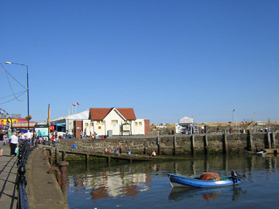
Figure 9.20. Old Harbour, Scarborough
Today these ports are still important elements of the UK economy and form the focus for many of the major shipping routes of the North Sea. In 2000, Tees and Hartlepool was the largest port in the North East region and the second largest in the UK. The Tees and Hartlepool port authority includes the ports of Middlesbrough, Billingham, Redcar and Hartlepool and is responsible for handling 11.7% of the UK's foreign and domestic oil and gas traffic and 6.8% of the UK's non-oil traffic. The large amount of foreign and domestic traffic handled by Tees and Hartlepool port and the regular ferry services from the port of Tyne, ensure that the density of ships in and around these ports is significant (currently 5,000-20,000 ships per annum) (DTI, 2002).
Surviving historical remains will include ruined quays, wharfs, jetties, mooring rings, chain and rope-worn bollards, batteries, lighthouses, rotting hulks of wrecked or abandoned boats, old customs houses, and former waterfronts.
Values and Perceptions
Ports are appreciated by both visitors and locals alike. Although some of these ports are now used by pleasure boats and just a few fishermen, people can easily imagine ranks of large sailing boats moored to the piers and quays at ports like Scarborough and fleets of fishing boats filing out of Whitby. Hartlepool and Tees are still valued as active ports and are fundamental to the employment of many people living in the area.
Smuggling is perceived as an exciting and romantic aspect of the history of this coast, with its suggestion of hidden contraband, secrecy, and suspicion, although the reality of the risks and unpleasant penalties were often far from it.
Research, amenity and education
Generally document-based histories of ports and harbours are plentiful, as well as work on coastal wrecks, but there is still much that can be learnt from the further study of harbours and their material remains, both extant and ruined. Specifically much needs to be done on the ports of this study area. Knowledge of levels of investment into structures, together with their capacity, mode of use, etc, can inform maritime histories. The potential for using visits to harbours to illustrate local history courses in schools and in further education is as great as the potential they have to inspire historians and writers.
Condition & forces for change
Many of the ports along this stretch of coast are still in use and have long, complex histories, often having been built up and modified over many centuries. A few are now abandoned and ruinous, serving as a reminder of some of the once thriving industries in these parts. Others may survive inland from the existing wharves.
Forces for change include neglect and reuse for other activities (e.g. marinas).
Rarity and vulnerability
Many of the features associated with the alum, coal, jet, ironstone, shipbuilding industries will be particular to this stretch of coast and therefore nationally rare. Some of the historic structures are protected as Listed Buildings.
Recommendations
Sustainable uses should be found for any surviving structures; reuse should incorporate as much of extant structures as possible. Abandoned and ruinous historic features should be taken into consideration during any proposed development. If necessary and where sustainable, resources should be put to the consolidation of important remains that are vulnerable to damage from natural weathering.
The recently published Marine Bill White Paper: A Sea of Change (March 2007) highlights that the current approach to authorising marine works in or near port or harbour areas 'is complicated and often archaic - some of the legislation dates back two centuries or more' (DEFRA March 2007, 59). It recommends that wherever possible a straightforward and consistent system of regulation applies in future. 'Antiquated rules and complicated provisions are particularly prevalent in local harbour acts and it is important that local navigational provisions should meet modern regulatory standards' (ibid). Out of date local rules need to be modernised to also include operations outside harbour areas as well as works within them where they are all part of the port infrastructure or operations. This will 'reduce the overlap of harbours and environmental legislation and the duplication of licensing....Where local powers to control the environmental or navigational impacts of works in a port or harbour are in place and effective, they should not be changed' (ibid).
Sources
Publications:
Friel, I, 2003. Maritime History of Britain and Ireland c.400 - 200, British Museum Press
Department of Trade and Industry, August 2002. Human Activities in the SEA 3 Area.
Labistour, P, 1996. A Rum Do. Smuggling in and around Robin Hood's Bay
Le Guillou, M, 1975. A History of the River Tees
Lewis, M J T, 1991. Ports & Harbours, in D B Lewis (ed) 1991, The Yorkshire Coast,156-165
Scarborough Archaeological and Historical Society, 2003. A guide to historic Scarborough
Smith, G, 1994. Smuggling in Yorkshire 1700-1850
White, A, 2004. A History of Whitby Phillimore, Bodmin
Websites:
http://portcities.hartlepool.gov.uk
http://www.wykes.org/wykes.html
