
England's Historic Seascapes: Scarborough to Hartlepool
Cornwall Council, 2007. https://doi.org/10.5284/1000201. How to cite using this DOI
Data copyright © Historic England unless otherwise stated
This work is licensed under the ADS Terms of Use and Access.


Primary contact
Charlie
Johns
Cornwall Council
Kennall Building, Old County Hall
Station Road
Truro
TR1 3AY
UK
Tel: 01872 322056
Resource identifiers
- ADS Collection: 744
- ALSF Project Number: 4731
- DOI:https://doi.org/10.5284/1000201
- How to cite using this DOI
Introduction | Seascapes Character Types
Processing Industry
- Introduction: defining/distinguishing attributes and principal locations
- Historical processes; components, features and variability
- Values and perceptions
- Research, amenity and education
- Condition & forces for change
- Rarity and vulnerability
- Sources
Introduction: defining/distinguishing attributes and principal locations
The Type Processing Industry includes the following sub-types:
- Production areas;
- Sewage and water works.
Principle locations include Hartlepool, Teesside, Redcar, Middlesbrough, Ruswarp, Whitby, Hawsker Bottoms, Saltburn and Scalby.
Historical processes; components, features and variability
Production areas
Components of the sub-type production areas include:
- iron and steel works;
- timber yards;
- brick, tile and clay works;
- potteries;
- mills;
- lime kilns;
- cement works;
- roperies;
- engine and boiler works.
Iron and Steel Works
The iron and steel industries have formed a significant part of the history and character of Cleveland and the River Tees for more than 160 years. Tees Estuary is ideally suited for this industry due to its proximity to the rich iron ores of the North York Moors and the fuel from the Durham coalfields, plus its ports allow easy export of the products. Middlesbrough's skyline is dotted with symbols of its steel and chemical industries; however, it was coal and iron in the 19th century that transformed the area from farmland and marshland to one of Victorian Britain's fastest growing towns. This dramatic increase in Middlesbrough's population first developed in the 1830s, following the birth of the town's coal industry and the 1840s, when Middlesbrough's iron ore industry took off.
Local smithies manufactured basic hand tools and machinery, along with fittings and fixtures such as gates and railings, as well as carrying out repairs. These rarely survived following industrialisation; when mass production of the smith's wares became possible. In Hartlepool there is evidence of this former industry (eg Hart Smithy) (Rowe 2000, 28).
The early iron ore was mainly from coastal exposures and most of this was shipped to Newcastle to be made into iron (Pybus Pers Com). By 1840 the first rolling mill and foundry had been built at Middlesbrough. Good quality ore was supplied from Grosmont near Whitby, but supplies were inadequate and transportation difficult. It went by sea, river and rail to Witton Park for smelting and the pig iron was then taken back by rail to blast furnaces at Middlesbrough to be made into iron. Ironstone was also being shipped from Skinningrove by 1848, but transport still remained a problem.
The iron industry does not appear to have developed as fully in Hartlepool as in Middlesbrough, Stockton and East Cleveland, presumably because of its remoteness from the ironstone mines themselves. Principal amongst the Hartlepool works was Seaton Carew Ironworks (Rowe 2000, 28).
By 1877, however, Cleveland was in crisis, as its ironstone was found to be rich in phosphorous and thus unsuitable for making the new Bessemer steel. The 'Eston Steelworks' were described as 'the largest and most advanced steel making plant in the world' (http://www.pancrack.tv/subject.html) and began mining suitable ore in Spain. In 1879 a way was found of making steel with Cleveland ironstone and this revolutionised steel-making throughout the world. The post-war boom saw Britain's premier steel-making centre remaining on the Tees and by 1967 it became part of the nationalised British Steel Corporation. British Steel later became CORUS and has since been taken over by TATA, now making around 3.5 million tons of steel a year.
Principal locations of iron and steel works today include Tees Wharf and Cochrane Wharfs on the Teeside, Redcar (Figure 9.8), Skinningrove. Historically they were also located at Throston, Stranton, Coatham, Grangetown, Middlesbrough, Runswick Bay, Egglescliffe, South Bank, North Ormensby, Port Clarence, and Seaton Carew.
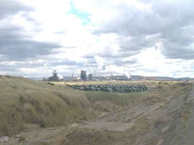
Figure 9.8. Teesside Works, Redcar, seen from South Gare
Timber Yards
Before iron ore could be properly handled, timber was 'the most essential raw material in almost all human activities' (Bruijn 1985, 127). In the second half of the seventeenth century all sorts of timber were in great demand; for naval and merchant ships, for pit-props in the Durham coalfields, and for the house-building industry, particularly after the Great Fire of London in 1666. In addition, English forests were shrinking. For all these reasons the import of timber into England from Norway and the Baltic Sea trade increased enormously (Bruijn 1985, 133).
Timber yards are typically large complexes of saw mills and ponds. The yard of Robert Launder and Co Ltd alongside the Timber Dock in Hartlepool (Figure 9.9) was established in 1853 and was in use until the 1980s . The Stranton Saw Mills, founded in 1878 and also in Hartlepool, are still in use as a timber yard. Other sites, such as the Baltic Saw Mills, opened in 1872, are in use for mixed light industry. Creosote works often accompanied timber yards, such as the Greenland Creosote Works at Cleveland Road which opened in the mid-1880s and continued in use until 1964 (Rowe 2000, 37).
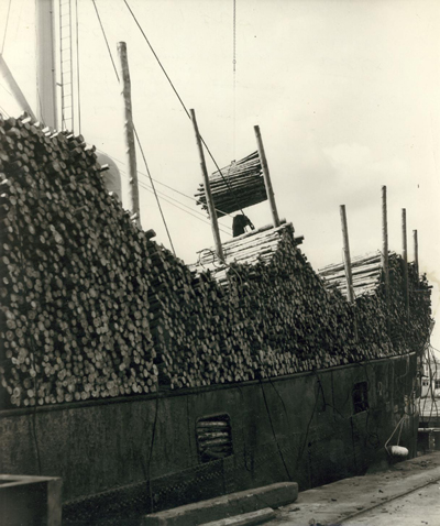
Figure 9.9. Timber being unloaded from a ship at Hartlepool (© Hartlepool Arts & Museum Service)
Principal historic locations include Hartlepool, Middleton, Stockton-on-Tees, Swainson Dock and Seaton Carew. Raff yards are also located at Whitby.
Brick, Tile and Clay Works
Brick and tile works are a poorly documented but very early industry, dating back as far as the Romano-British period, having been introduced by the Romans. Transport in bulk of building materials such as bricks and tiles over long distances was rare before the age of canals, railways, roads and heavy goods vehicles. Before this time they were generally made as close as possible to their point of intended use. Bricks were often used even in areas where stone was available, for reasons of speed and economy. The buildings of the Industrial Revolution in Britain were largely constructed of brick and timber due to the unprecedented demand for rapidly and cheaply built accommodation for local workers. Although houses are now mainly built using a mixture of concrete blocks and other materials, many are skinned with a layer of bricks for aesthetic appeal. Clay is a predominant geological mineral for most of north Yorkshire deriving mainly from the glacial dposits. As such clay exploitation in this area is relatively ubiquitous with transport costs dictating the approximate spacing between brick and tile works.
There are very few surviving remains of the many brick and tile works shown on the 1st edition OS map survey of 1857 in this area. Some remains can still be found at Tilery Farm, Throston (Figure 9.10). It is named 'Brick Garth' on the 1840 Tithe Survey suggesting that it was in operation from at least this period, but had gone out of use by the 2nd edition OS survey in 1898. Typical components of these works were rectangular tile kilns built of red bricks with fire brick floors and tunnel-vaulted roofs (Rowe 2000, 22).
Figure 9.10. Tilery Farm, Throston (© Tees Archaeology)
There are no active brick, tile or clay works in this area and survival of remains tends to be poor. Historical locations included Yarm, Stockton-on-Tees, Port Clarence, North Lackenby, Hart Warren, Middlesbrough, Eston, Preston Park, Egglescliffe, Lofthouse (now Loftus), Boulby, Goldsborough,Upgang and Scarborough. Clay works tended to be restricted to Billingham and South Stockton.
Potteries
Clay was also a useful material for the local pottery industry. In 1825 William Smith opened his Stafford Pottery at South Stockton followed in 1860 by his brother James' factory at Stockton called the North Shore Pottery. Other potteries included the Ainsworth's white and printed ware pottery of North Stockton and the Harwoods Norton Pottery which specialised in the so-called 'Sunderland Ware'. A pottery was also started by William Smith in 1880 at Cliff House, Hartlepool, but closed in 1897. Waste pieces from this pottery can still be found in quantity around the town. The quantity of waste was a real problem for most potteries and it was often given away for use as an aggregate. At the time the Cliff Factory closed it was said that the waster pile stood fifteen feet in height. A selection of some of the more decorative wares from this factory is on display at the Museum of Hartlepool (Rowe 2000, 37).
Historic potteries are recorded at Stockton-on-Tees and Hartlepool. Scarborough was also an important pottery-making centre in the Medieval period; kilns being situated along Castle Road, where the natural glacial clay was particularly suitable for making pots. The distinctive Scarborough Ware was used extensively in the town and by most of the villages but was also traded abroad through the port. It has been discovered at archaeological excavations in Scandinavia and the Low Countries and pieces have even turned up in Iceland. After the Scarborough pottery industry ended in the fourteenth century, the townsfolk obtained their earthenware from potteries in Ryedale and around the Humber Basin. Much was imported from the North Sea, the Low Countries, Germany and even Spain (Scarborough Archaeological and Historical Society 2003, 44).
Mills
The economy of north east Yorkshire was mainly agricultural prior to the mid 1830s and milling was amongst the earliest industries in this area. Windmills, being conspicuous landscape features, could often be viewed from the rivers and coast and frequently served as navigation landmarks. Windmills are mentioned in Hart in 1314 and at Elwick in 1606. A disused windmill at Hart was one of the last to operate, closing in 1915. The remains of West Hartlepool Mills, which opened in 1847, can also still be seen, now converted into a bar and nightclub (Rowe 2000, 32). Watermills, although no longer operational, can be found along the many streams and rivers within this area, either as ruins or converted into dwellings. Streams and rivers had leats taken off them from at least medieval times to work the water mills used in grinding grain.
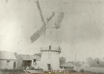
Figure 9.11. Greatham Mill (© Hartlepool Arts & Museum Service)
Historically mills were located at Hartlepool, Greatham (Figure 9.11), Thornaby, Billingham, Teesside (Normanby Wharf), Saltburn, Staithes, Skeleton, Stranton, Loftus, Whitby, Ruswarp, Stainacre, Hinderwell, Scalby Mills, Scarborough and Cayton Bay.
Lime Kilns
As well as being used for building stone, limestone was also burnt and mixed with sand to produce lime mortar. Lime burning kilns were in use from the medieval period and an example dating to the late 13th century was excavated at Hart in 1972-3. That kilns were established in Hart in the medieval period suggests a very early date for the beginning of many of the quarries in this area. Individual kilns are shown on the 1st edition maps but it is likely that they soon went out of use with the boom of cement manufacture in the 1860s and the increased use of cheaper South American imported lime.
Lime kilns were commonly situated in the floor of the quarry itself, as can be seen at Hart and Dyke House. Other kilns were built at the cliff base, for example along the north sands of Hartlepool Headland. The kilns would have been loaded from the top and their location on quarry floors or cliff edges would have allowed the load to be dropped in from a higher point rather than being hoisted up. The kilns at Hartlepool headland probably exploited lime blasted directly from the cliff face (Rowe 2000, 24).
Limestones are absent between Redcar and Ravenscar - the lime kilns operating in these areas providing agicultural and constructional limes were opering with limestoines usually transported as ballast in returning ships from the south of England and often were colliers and alum ships (Pybus Pers Com).
Lime kilns have been recorded at Throston, Hartlepool, Middlesbrough, Ruswarp, Saltburn, Saltwick Bay, Skinningrove, Staithes, Runswick Bay, Upgang, Cloughton, Hawsker Bottoms, Burniston and Scalby.
Cement Works
Modern hydraulic cements began to be developed from the start of the Industrial Revolution, driven by three main needs: hydraulic renders for finishing brick buildings in wet climates, hydraulic mortars for masonry construction of harbour works etc, in contact with sea water, and the development of strong concretes. In Britain particularly, good quality building stone became ever more expensive during a period of rapid growth, and it became a common practice to construct prestige buildings from the new industrial bricks, and to finish them with a stucco to imitate stone. Hydraulic limes were favoured for this, but the need for a fast set time encouraged the development of new cements. The use of concrete in construction grew rapidly from 1850 onwards, and was soon the dominant use for cements.
In Hartlepool, the earliest cement works established was the Warren Cement Works set up in 1852. The company capitalised on the large amounts of chalk ballast dumped by colliers returning from the Thames estuary. This site was long-lived, eventually closing in 1939. The works have since been reclaimed and levelled as a sports pitch (Rowe 2000, 24).
In 1795 (check date) Parker patented his Roman Cement that was so-called because of its superficial resemblance to the cement used by the Romans. This cement was a particularly fast setting hydraulic cement based upon the calcinations and crushing of limestone nodules found in the upper portion of the Jurassic shales and now know as "cement shales". Initially the nodules were a waste from the alum mining process but following the closure of the alum mines at Sandsend the cement industry there developed a simple mining process of adits in the backs of the alum quarries.
Cement works have been recorded at Preston-on-Tees, Throston, Hartlepool, Loftus and Sandsend.
Roperies
From the Medieval period, ropes were constructed in rope walks, very long buildings or yards where strands the full length of the rope were spread out and then twisted together to form the rope. Cable length was thus set by that of the walk; ropes over 300 yards long could be made, as short ropes had little value on tall ships which required ropes to be long, relatively uniform in diameter, and strong.
There is perhaps less evidence for rope making than one might expect in the major ship-building ports in this area. A ropery opened at Hart Warren, Throston in 1855 consisted of a linear rope walk with a turning house at the eastern end. This had developed into the 'Wire Rope Works' by 1897 when the walk was shown replaced with a linear building on the same site (Rowe 2000, 37). Rope making associated with Stockton's role as a shipbuilding centre was an industry of significance judging from the importing of 1,178 tons of hemp into the town in 1825.
There were also five roperies working at Whitby in the early 19th century, all on the fringes of the town because of the need for long straight alleys for the rope-walks. The two largest were on the east side, one on the cliff-top above Boulby Bank, 440 yards long, and one running parallel to Spital Beck (White 2004, 95) (Figure 9.12).
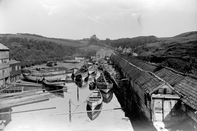
Figure 9.12. Spital Ropery, Whitby (© Whitby Museum)
Engine and Boiler Works
The development of ports and the coming of the railways led to an increased demand for ship and locomotive engines and other complex machinery. This was initially dealt with on a small scale by local ironworks and smithies but by the late 19th century separate engine works begin to emerge, for example William Grey's engine works at Central Dock, Hartlepool. This became known as the 'Central Marine Engine Works' and provided for the engineering needs of Grays Shipyards until 1961 (Rowe 2000, 21).
Historically engine works were located at Middleton, Middlesbrough and Stockton-on-Tees.
Sewage and Water Works
Components of the sub-type sewage and water works include:
- sewage treatment works;
- water treatment works;
- sewage pipelines;
- diffusers;
- outfalls;
- pumping stations;
- reservoirs.
Sewage outfalls and pipelines are located at North Sands (Hartlepool), Redcar Sands, Cornelian Bay, Cattersty Sands, Saltburn (Figure 9.13), Scalby Ness Sands. Pumping stations can be found at Killerby Cliff, Redcar, Bran Sands, Seaton Carew, Hartlepool, Scalby Mills and South Cliff (Scarborough).
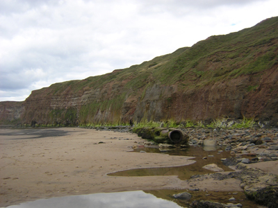
Figure 9.13. Disused sewage pipeline on the foreshore at Saltburn
Sewage from residences, institutions, and commercial and industrial establishments is either treated close to where it is created (in septic tanks or onsite package plants and other aerobic treatment systems), or collected and transported via a network of pipes and pump stations to a municipal treatment plant. Their objective is to produce a waste suitable for discharge or reuse back into the environment.
Expansion of the towns and villages in this area during the 19th century also meant that water supplies needed to be rationalised. Previously water had been obtained from local wells and springs. Where wells and springs were too brackish, as at Hartlepool, water was transported from elsewhere by carts. Water works, including two water towers, were established at Hartlepool in the floor of Dyke House Quarry, where a number of wells were set up at existing spring heads. The only remains left of this site today, however, are the iron wave-effect railings (Rowe 2000, 30). Water works are also located at Ruswarp and Scarborough.
Reservoirs (20th century water bodies retained by built dams) are primarily located in uplands or in steep river valleys. They were mainly built in the second half of the century to ensure plentiful supply for domestic, agricultural (irrigation), and industrial use. The largest reservoirs within this pilot area can be found at Ruswarp by the River Esk (manily constructed to provide a head of water for Ruswarp Mill), Scaling Dam near Loftus and at Harlepool (Hart Reservoirs) by the River Tees. The reservoirs at Hart (Figure 9.14) were built in 1865 and survive in particularly good condition but only supply the Magnesia Works at North Sands (Rowe 2000, 30) but which has since closed. Other reservoirs include Lockwood Beck Reservoir and Randymere Reservoir. There are also many smaller, usually early 20th century reservoirs, not all of which, because of size, are able to be expressed in this HSC. Every alum works has a water supply network based on reservoirs and open or buried channels for the water to be routed to where it is needed. These supply networks are generally un-recognised.
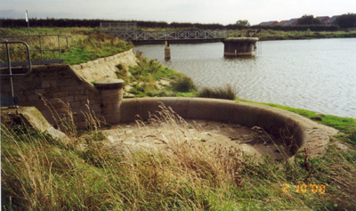
Figure 9.14. Hart Reservoir, Hartlepool (©Tees Archaeology)
Some reservoirs are public amenities, generally built on land obtained by compulsory purchase and are very important as the most visible component of a major engineering feat of the 20th century, reflecting the sophistication, complexity and stability of a society that could bring piped water to virtually every household. Reservoirs are generally functional in design and components often include pumping stations, water treatment works, and associated workers cottages. Secondary uses of reservoirs include recreational activities such as sailing, fishing, or water skiing, such as at Scaling Dam.
Values and Perceptions
Processing areas, as places of work, are full of meaning. They are also regarded as functional, noisy, smelly and so detracting from the beauty of an area.
Sewage and water works are also functional and often smelly, accepted as essential public amenities. Opposition to new works and pipelines is increasing, for aesthetic, environmental and heritage reasons.
Reservoirs are highly valued by local populations who use them for leisure activities.
Research, amenity and education
Processing areas have plenty of potential for undertaking historical and archaeological research. Some features, such as mills and limekilns may be suitable for presentation - amenity value.
Historical research of reservoirs may throw light on the methods of selection of sites. Archaeological information can be gleaned from their shorelines and, with more sophisticated planning constraints, there will be greater opportunities to undertake detailed recording in advance of any future reservoirs. Although not directly related to the historical landscape, the amenity potential of reservoirs is great, not only for fishing and water sports but also as wildlife havens
Condition & forces for change
Historic windmills are being preserved for their historic value in some places. With increasing environmental concern, and approaching limits to fossil fuel consumption, wind power has regained interest as a renewable energy source but it is not feasible to reconstruct old fashioned windmills so this statement is irrelevant here.
Large reservoirs are carefully maintained and survive well but many smaller reservoirs are not so well tended and there is specific legislation to ensure risks to the public and workforce are minimised. The features they inundate, however, often do not. The reservoirs and ancillary features will be in good condition, being maintained, but other historical features will generally be in poor condition.
Rarity and vulnerability
Some processing areas may be nationally or regionally rare. But few if any will be protected.
Reservoirs are most important as an amenity and as a dramatic contributor to landscape character.
Recommendations
'All forms of leats, mill races and broader water management in the region require further research' (Petts and Gerrard 2006, 224). Numbers of unimproved mills are now very low; consider with care any further applications for conversion or improvement. The Windmill Hotel in Mill Street, Scarborough, stands as a splendid example of how redundant heritage buildings can be put to modern use without spoiling their appearance.
'This region's long tradition of metalworking, including iron and steel making, and non-ferrous manufacture also needs further research in order to gain a better understanding of these metalworking processes, in particular those carried out on domestic or craft scale' (Petts and Gerrard 2006, 224).
Sources
Publications
Bruijn, JR, 1985. The Timber Trade, in A Bang-Andersen et al (eds), 1985, The North Sea: A Highway of economic and cultural exchange, Character-history. Norwegian University Press, 123-136
Department of Trade and Industry, 2002. SEA 3: Human Activities in the SEA 3 Area: technical report. DTI
Petts, D and Gerrard, C, 2006. Shared Vision. The North East Regional Research Framework for the Historic Environment. Durham County Council
Rowe, P, 2000. Industrial Archaeology in Hartlepool. Tees Archaeology
White, A, 2004. A History of Whitby Phillimore, Bodmin
Websites:
http://www.northeastengland.talktalk.net/Stockton.htm
http://www.pancrack.tv/subject.html
http://www.bbc.co.uk/legacies/immig_emig/england/teesside/index.shtml
http://www.bbc.co.uk/nationonfilm/topics/chemical-industry/
http://www.bbc.co.uk/nationonfilm/topics/steel/
