
England's Historic Seascapes: Scarborough to Hartlepool
Cornwall Council, 2007. https://doi.org/10.5284/1000201. How to cite using this DOI
Data copyright © Historic England unless otherwise stated
This work is licensed under the ADS Terms of Use and Access.


Primary contact
Charlie
Johns
Cornwall Council
Kennall Building, Old County Hall
Station Road
Truro
TR1 3AY
UK
Tel: 01872 322056
Resource identifiers
- ADS Collection: 744
- ALSF Project Number: 4731
- DOI:https://doi.org/10.5284/1000201
- How to cite using this DOI
Introduction | Seascapes Character Types
Sea Defences
- Introduction: defining/distinguishing attributes and principal locations
- Historical processes; components, features and variability
- Values and perceptions
- Research, amenity and education
- Condition & forces for change
- Rarity and vulnerability
- Sources
Introduction: defining/distinguishing attributes and principal locations
The Type Sea Defences includes the following sub-types:
- Breakwaters;
- Groynes;
- Sea walls;
Components of this Type can include:
- lighthouses, lights, lifeboat stations;
- mooring posts and rings, bollards, ladders;
- military defences (such as pillboxes, batteries, gun emplacements);
- fishermen's huts.
A sea defence can be defined as a structure protecting a harbour or beach from the destructive force of sea waves and from flooding. They are in place in some form or another at almost all the coastal settlements and other vulnerable areas along this stretch of coast.
Historical processes; components, features and variability
Coastal management or coastal defence is used throughout the world for many different purposes, but predominantly to reduce coastal erosion and flooding. There are many techniques of coastal management including 'hard' and 'soft' construction and planning approaches. Hard construction is the more traditional response to erosion and involves the construction of structures which stop wave energy reaching the shore, or absorb and reflect the energy. These have often caused problems themselves, such as increasing erosion elsewhere, and soft construction techniques have become more popular because of this. These techniques involve promoting natural systems such as beaches and salt marshes which protect the coast, and are usually cheaper to construct and maintain than hard construction techniques, and may be self-sustaining.
Breakwaters usually consist of large rocks piled or placed at the foot of cliffs, often supplementing native stones of the beach. They absorb wave energy and hold beach material but tend to be unpopular as they are unsightly. Longshore drift is not hindered, these have a limited lifespan and are not effective in storm conditions. They also reduce the recreational value of a beach. Boulders and rocks can also be wired into mesh cages (gabions) sometimes at cliffs edges or protruding at a right angle to the beach like a large groyne. When the seawater breaks on the gabion, the water drains through leaving sediment; also the rocks and boulders absorb a moderate amount of the wave energy. In some cases enormous concrete blocks and natural boulders are sunk offshore to alter wave direction and to reduce the energy of waves and tides. The waves break further offshore and therefore reduce their erosive power.
The most significant breakwater in this study area is the South Gare Breakwater, which extends outwards from Tees Mouth. This was opened in 1888, its construction prompted by the wrecking of over 60 ships near the mouth of the River Tees. The purpose being 'improving and protecting the navigation of the River Tees, and affording shelter and refuge to shipping of the north-east coast' (Le Guillou 1975, 47). A tramway was used to bring in nearly 5 million tonnes of slag from the local steelworks for its construction. It was 2.5 miles long and took 25 years to build (ibid). At the opening of the South Gare a time capsule was placed inside the foundation stone and contains copies of local newspapers for that day and a scroll with the names of all the Tees Commissioners. Other breakwaters can be seen at Whitby, Robin Hood's Bay, Staithes, and the Heugh at Hartlepool. Boulder breakwaters are in place at Scarborough (providing additional defence for East Pier as well as all around the headland and Marine Drive to North Bay) (Figure 9.21).
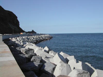
Figure 9.21. East Pier Breakwater at Scarborough
Groynes are wooden, concrete and/or rock barriers or walls at right angles to the sea. Beach material builds up on the updrift side, where littoral drift is predominantly in one direction, creating a wider and a more plentiful beach, therefore enhancing the protection for the coast because the sand material filters and absorbs the wave energy. However, there is a corresponding loss of beach material on the downdrift side, requiring that another groyne be built there. Moreover, groynes do not protect the beach against storm-driven waves and if placed too close together will create currents, which will carry sand material offshore. Groynes are extremely cost-effective coastal defence measures, requiring little maintenance, and are one of the most common coastal defence structures. Groynes are increasingly viewed as detrimental to the aesthetics of the coastline, and face strong opposition in many coastal communities however the converse is true in this region with much popular opinion on favour of Groynes and much resistance by the coastal authorities to maintain existing groynes. Groynes are the most dominant form of sea defence at Marske Sands (Figure 9.22) and Redcar Sands. One is also in place on Black Rocks in Scarborough's South Bay. Relic groynes can be found at Sandsend while the ones at Whitby have been removed.
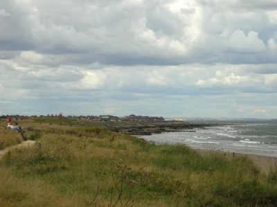
Figure 9.22. Groynes at Marske Sands
Sea walls, usually of concrete and/or stone, tend to be built at the base of a cliff or beach, or used to protect a settlement from eroding. Seawalls aim to resist and reflect the energy of the waves back out to sea, and for this purpose are often curved which also deflects sediment, and adds greatly to the power of backwash. As a result, the same result will happen akin to those of destructive waves. Furthermore, sometimes the reflected wave or energy helps the rapid depletion of the attached beach. In some cases, sea walls have caused the loss of so much beach material that the base of the sea wall has been exposed and undermined. Sea walls are the most traditional methods used in coastal management within this area and good examples can be found along the Heugh headland at Hartlepool, Runswick Bay, Sandsend (Figure 9.23), Whitby and at Robin Hood's Bay.
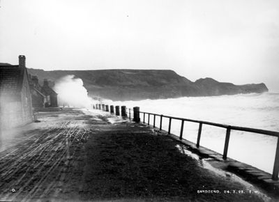
Figure 9.23. Sea wall defence at Sandsend (© Whitby Museum)
Values and Perceptions
Sea defences are most often seen as essential for the preservation of the settelments along this inhospitable North Sea coast, and for the safety of the people who live in them. Some of the more recent sea defences are viewed by some to have had a detrimental effect on the picturesque character of some of the smaller fishing villages in the area.
Research, amenity and education
Sea defence has been undertaken in England for many centuries and as such some early coastal defence systems the focus of historical and archaeological interest (Fulford et al 1997, 190)
Condition & forces for change
The main forces for change are the unending battle with the sea, exacerbated by the effects of the climate change (more storms and rising sea-levels). Sea defence policy is also a major force for change and changes in such policy have produced significant alterations in the types and locations of the sea defences being implemented, particularly arising from the recognition of the need for sustainability (Dave Hooley Pers Com).
With coastal erosion threatening our seaside communities, natural habitats, historic environments and Britain's future development opportunities, coastal defense is now high on the agenda. In response to this Defra have made significant progress in understanding and mapping coastal processes through the development of Shoreline Management Plans (SMPs). These provide a large-scale assessment of the risks associated with coastal processes and present a long term policy framework to reduce these risks to people and the developed, historic and natural environment in a sustainable manner.
In addition the current Environment Agency policy on sea defenses involves strategic planning to make decisions about maintaining and building new flood defenses, as well as raising public awareness of people living in vulnerable areas. They also advise local, regional and central government on the building of sea defenses and the impacts they will have on the environment.
Archaeological remains can be affected by construction and maintenance operations, as well as by the indirect impact of the defences. In Hartlepool Bay patterns of sand movement and accumulation have changed in recent years with the growing extent of the sea defences so that now there substantial depths of modern beach sand covering the underlying deposits of peat and clay, which formerly were exposed from time to time (Waughman 2005, 42).
Rarity and vulnerability
Not rare and therefore not designated, but often vulnerable.
Recommendations
Many operating authorities have adopted the Shoreline Management Plans (SMPs) recommendations as a basis for production of individual strategic plans, monitoring programs and studies for all or part of their coastline. These first generation SMPs are now due for review to ensure full account is taken of latest information and future challenges.
Consider aesthetics and historic character, as well as the effect they are likely to have on archaeological remains, when developing future sea defences.
Managed retreat is one favourable action which may counter the effect of sea defences on archaeological remains. The benefits of managed retreat include the re-submergence of deposits which were formally periodically wet, providing an enhanced environment for preservation of fragile, organic material, and increased deposition of material on the surface of sites, providing protection against mechanical weathering (Fulford et al 1997, 192).
Sources
Publications:
Fulford, M et al, 1997. England's Coastal Heritage. A Survey for English Heritage and the RCHME. RCHME and English Heritage.
Le Guillou, M, 1975. A History of the River Tees
Waughman, M, 2005. Archaeology and Environment of Submerged Landscapes in Hartlepool Bay, England, Tees Archaeology Monography Series 2.
Websites:
http://www.defra.gov.uk/environ/fcd/policy/smp.htm
http://www.environment-agency.gov.uk/
http://en.wikipedia.org/wiki/Sea_defences
http://www.wildlifetrust.org.uk/teesvalley/Heritage/breakwater.htm
