
England's Historic Seascapes: Scarborough to Hartlepool
Cornwall Council, 2007. https://doi.org/10.5284/1000201. How to cite using this DOI
Data copyright © Historic England unless otherwise stated
This work is licensed under the ADS Terms of Use and Access.


Primary contact
Charlie
Johns
Cornwall Council
Kennall Building, Old County Hall
Station Road
Truro
TR1 3AY
UK
Tel: 01872 322056
Resource identifiers
- ADS Collection: 744
- ALSF Project Number: 4731
- DOI:https://doi.org/10.5284/1000201
- How to cite using this DOI
Introduction | Seascapes Character Types
Settlement
- Introduction: defining/distinguishing attributes and principal locations
- Historical processes; components, features and variability
- Values and perceptions
- Research, amenity and education
- Condition & forces for change
- Rarity and vulnerability
- Sources
Introduction: defining/distinguishing attributes and principal locations
The Type Settlement includes the following sub-types:
- Cities;
- Towns;
- Villages;
- Hamlets.
Built-up areas from larger hamlets upwards; includes urban industrial estates and also small areas of open land if surrounded by built-up land.
The coastal region of this study area is predominantly rural along much of its length and contains sparsely populated areas with scattered small towns and villages. Areas of dense population are associated with the industrial centre of Teesside, as well as the ports of Whitby and Scarborough.
Historical processes; components, features and variability
A complex Type with numerous historical trajectories contributing to its present form.
The locations of the villages along this coast, with their concern for shelter from the storm and a safe haven for boats, leave little doubt that the first settlers here were seafarers. Staithes, Runswick, Robin Hood's Bay (Figure 9.70) and Scarborough all hug the northern end of their bays to huddle in the lee of the headlands. Freshwater was another prime consideration and several fishing settlements grew up where becks and rivers entered the sea (Frank 2002, 43).
.jpg)
Figure 9.70. Robin Hood's Bay (© Sutcliffe Gallery (www.sutcliffe-gallery.co.uk))
In the fishing villages houses tend to be built as close as possible to the waterside, Staithes being an extreme example (Figure 9.71). This was largely so that the fisherfolk could be constantly near to their boats, the principal wherewithal of their livelihood. At Whitby the fishing community lived in the narrow streets by the harbour (Frank 2002, 44).
.jpg)
Figure 9.71. Staithes (© Sutcliffe Gallery (www.sutcliffe-gallery.co.uk))
The fishing village of Runswick is 'a singular rookery of cottages built with only walking space between them, one above another in the cliff side, clinging to the face of the treacherous cliff like a colony of martins' (Frank 2002, 47) (Figure 9.72). This close proximity to the sea and cliffs meant that these settlements were often prone to disasters. At Runswick portions of the cliff are noted to have been occasionally 'shooting' and houses were often dislocated or wholly demolished, and instances are said to have occurred of houses slipping down entirely, together with their bases, and taking up a fresh position below (Frank 2002, 48).
.jpg)
Figure 9.72. Runswick Bay (© Sutcliffe Gallery (www.sutcliffe-gallery.co.uk))
Runswick and Staithes were predominantly fishing villages, but elsewhere, as at Whitby and Scarborough, the fishing community was only part of a larger population. Fisherfolks' homes were working places as well as dwellings. It was there that most of the gear was made, mussels and limpets were shelled, and lines cleaned and baited (Frank 2002, 54)
Until the end of the WWII many settlements lacked basic, modern, sanitary amenities. A great many, too, were tenement buildings erected in the second half of the 18th century to accommodate the influx of labour to work in the shipyards, graving docks and ironstone mines (Frank 2002, 47).
Many rural settlements will have their origins in the Early Medieval period, or even earlier, but most extant buildings (except churches) are post-medieval or modern. Virtually all rural settlements large enough to be included in this Type have extensive later 20th century housing estates at their edges.
The long and complex histories of these settlements have produced a wealth of historical and archaeological features. Clearly some settlements will be simpler than others, notably the post-medieval industrial and harbour villages but all will have a variety of building types, ages and styles, different sectors for residence, commerce, industry, storage, recreation, burial and ceremonial. Some will also have military remains (from medieval castles to 20th century pillboxes). Most settlements will have rich subsurface remains with the footings of buildings and features of medieval or even earlier date.
Medieval coastal towns and villages tended to have had harbours and fishing populations, while others on tidal rivers (often now silted) were trading centres. These medieval settlements were small, with towns of just three or four main streets and small resident populations.
In the post-medieval period, settlements grew slowly until the 18th century when increased mining activity led many to expand more rapidly and the growing commercial activity caused some others to follow. Several new towns and industrial villages also grew up along the coast as a result. Without the development of ironstone mining many of the small villages we see today in East Cleveland would not have been formed. The housing in these small communities was normally provided by the mine owners who also built schools, hospitals, chapels and occasionally Working Men's Clubs. The houses were often built in terraces and were usually two up, two down with an allotment to the rear of the house. The closeness of the houses created a special bond between the families who would all make their living out of the pits. A number of terraced houses can still be seen in many of the villages today.
The alum works also needed local workers and by the 18th century the original coast road running from Staithes to Skinningrove was dotted with hamlets for these workers, at Boulby, Streethouses, Upton and Micklow (Chapman 2002, 74). It has also been suggested that the development of the alum industry in the Whitby district was the catalyst which began the conversion of Whitby from a minor fishing station with a modest hinterland into the major Georgian port that it became (Pybus 1991, 54).
By as late as 1801 Middlesbrough was still only a small farm of twenty five people. In 1830 Stockton and Darlington Railway line was extended to Middlesbrough, making the rapid expansion of the surrounding towns and ports inevitable. By 1851 Middlesbrough's population had grown from 40 people in 1829 to 7,600 and it was rapidly replacing Stockton as the main port on the Tees. Today Middlesbrough has a population of over 150,000 and is undoubtedly the heart of the Teesside conurbation and the modern 'Capital' of the area. An old Teesside proverb had proven true;
'Yarm was, Stockton is, Middlesbrough will be' (*).
More recently, from at least the late 19th century (or earlier in the case of Scarborough (Figure 9.73)), some coastal settlements have developed to serve the tourism industry. Most were extant harbour or fishing settlements. Some however, such as Ravenscar, represent a failed attempt to turn such settlements into coastal resorts. From the 1960s onwards the increasing cheapness and more attractive climatic conditions offered by the package holiday to the Mediterranean and beyond appeared to spell the demise for many seaside towns, athough many are now beginning to reinvent and re-launch themselves.
In the 20th century, virtually all settlements in this Type expanded through the provision of housing estates for local families and new residences for a growing population of retired people and people wanting second or holiday homes. Many settlements are largely residential now, most of their original industrial, harbour and commercial functions having died, their original cores now dwarfed by 20th century expansion.
There is an abundance of material remains of the last three hundred years in most towns and the street plans, market places, and surviving medieval buildings (e.g. castles and churches) take people back a further four or five centuries. Street names may also reveal now lost features or activities (e.g. Far Jetticks, Friarage Field, Iron Scar, Whale Hill) and the steady trickle of discoveries of artefacts and features encountered during developments and roadworks in towns reminds observant dwellers of the richness of their town's past.
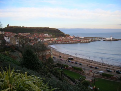
Figure 9.73. Scarborough, South Bay, overlooked by Scarborough Castle on the headland
Values and Perceptions
The majority of settlements along this stretch of coast are hamlets, villages and towns, the city of Middlesbrough being an exception. There is little that is cosmopolitan (except, perhaps in Scarborough and Whitby) and much that is strictly functional. The hamlets and rural settlements along this coastline are highly valued by both local people and visitors. Their organic layouts are interesting and satisfying to either live in or pass through, and the numerous 17th century or older buildings add beauty and antiquity to the places.
The mining and fishing communities are remembered nostalgically as having been special kinds of places, where it was safe to leave the door unlocked for your friends just to pop in and say hello. Everybody knew everybody and it made the community a safe place to live in.
To many of the painters, writers and photographers who, from the 1880s onwards, flocked to the Yorkshire coast the jumble of houses, red pantiled roofs one atop another, and the maze of courts, steps and yards of the fishing quartiers were merely picturesque, although some had a proper appreciation of the problems of living in such cramped and often overcrowded dwellings (Frank 2002, 50).
In his novel The Nagars of Runswick Bay, J.S. Johnson (1973) has left a detailed impression of fisherman's cottages at Runswick Bay:
'As most of these cottages were built on the steep hillside, they consequently only had windows which looked towards the bay, and many of these were very small. Being built in these positions and having open coal fireplaces many of them smoked when the wind was in a certain quarter,further adding to the family's discomfort. One or two I often went into
during the day were so dark I had to stand still when I first entered until my eyes became accustomed to the gloomy darkness'
The decline of the commercial centres of many towns, as out-of-town superstores take their toll, is perceived by most people as a negative force for change, removing traditional businesses and gradually removing the meaning from these places.
Research, amenity and education
The extent to which wider patterns of settlement have been studied varies immensely. Whereas sociologists and historical geographers have researched patterns of urban regeneration, there has been less exploration of the architecture and landscapes destroyed and created as part of this process. Many smaller settlements have also seen tremendous change over the course of the 20th century, although not on the scale of urban centres. Lack of work on villages reflects an absence of research on the 20th century rural landscape generally (Petts and Gerrard 2006, 190).
In rural settlements, extant buildings and the layout of surviving features will repay close study and, in addition, there will inevitably be a wealth of sub-surface settlement remains, some dating back into later prehistory. The study of various kinds of documents will also shed considerable light on settlements.
These coastal towns and villages are important elements of North Yorkshire's tourist industry, often as seaside resorts or refuges on rainy days. Many have historical features (e.g. churches, castles and bridges) which are displayed to visitors and some have interpretative leaflets or booklets to guide people around. There is, however, still considerable potential for a discreet, unobtrusive presentation of the past in most towns. This can be aimed as much at towns' inhabitants, particularly children, as at visitors and will have the benign effect of increasing peoples' awareness of the historical value of their homes.
Condition & forces for change
Although settlements have continued to change right into the late 20th century, as places which are hubs of human activity are bound to do, the layouts and historic fabrics of most are relatively well-preserved. There was minimal bombing damage in World War Two, except at Hartlepool, and most towns' main streets have essentially 19th century or earlier frontages with relatively few disfiguring, modern, standardised shop windows and signs. Towns like Scarborough and Whitby are particularly well-preserved.
Where layouts have suffered little change, there is a good likelihood that subsurface remains are also well preserved. Rural settlements are also generally well preserved, with modern developments usually lateral expansions from an historic core rather than replacements.
The good survival of street plans in most towns allows earlier organisations to be easily understood. Clearly over the centuries since most towns were established foci of activities have shifted but it is usually possible to work out sequences of relationships of features. At Scarborough, for example, the medieval castle still dominates the town but other, later features, built or created in relation to it, have formed nuclei for other streets and buildings.
In towns, the condition of historic buildings, streets and layouts is generally good. Subsurface features can also be expected to survive well. Rural settlements are also fairly well-preserved where modern developments have avoided their historic cores.
Being the places where people live and carry out much of their business, settlements have always changed more rapidly than most other elements of the landscape and will no doubt continue to do so. The accommodation of new means of transport (road, rail) is a key area for large scale, often damaging change, both within towns and also in their immediate surroundings.
Town centres are vulnerable to piecemeal facelifts by competitive businesses keen to attract customers, and residential districts are most at risk from certain forms of home improvement, most notably at present by the replacement of windows, doors and roofs by standardised plastic and asbestos materials.
The character of towns is being most fundamentally changed by the construction of new housing, often in the form of estates of virtually identical houses whose architecture does not always appear to have its roots in Yorkshire traditions.
Rural settlements are most vulnerable to insensitive conversions from agricultural or industrial to purely residential accommodation; the creation of mini-suburbs in the countryside and the draining of historical meaning and distinctiveness.
Rarity and vulnerability
Many settlements contain historically and architecturally important structures which are registered Listed Buildings and receive statutory protection. Conservation Areas also exist in most towns, usually in the historic cores. Local Plans reinforce these planning controls. The Sites and Monuments Record for towns is being gradually improved but requires a systematic reassessment of urban archaeological remains. Some settlements will fall within areas covered by broader designations.
Towns and villages are of high importance as features of the landscape, having a wealth and great variety of historical and archaeological components, demonstrating considerable time-depth and contributing much to the areas appearance and character. There is also enormous potential for further historical research and educational amenity use.
Recommendations
The use of Conservation Areas to control planning in towns and rural settlements should be retained and extended.
Regulations concerning replacement elements such as windows, doors and roofs should be enforced.
The loss of historic landscape at the edge of towns and rural settlements should be carefully considered when dealing with plans for edge developments (housing/industrial estates, bypasses etc).
Historic layouts and features, for example buildings relating to commercial, social and religious concerns, are very important for maintaining links with settlements' origins and development and for enhancing local distinctiveness. They should be explicitly identified and preserved.
Development in towns should respect traditional layout of streets, open areas and burgage plots. Large developments, such as in-town car parks, which over-ride and obliterate historic town/village features should be discouraged and careful consideration given to alternative proposals and sites. Full Extensive Urban Survey (EUS) of the area's larger settlements should be carries out in conjunction with the completion of the HLC in this region.
Sources
Publications:
Chapman, K, 2002. Boulby Alum Works, in I Miller, 2002, Steeped in History. The Alum Industry of North East Yorkshire. Oxford Archaeology North
Frank, P. Yorkshire Fisherfolk. Phillimore, Bodmin
Herring P, 1998. Cornwall's Historic Landscape. Cornwall Archaeological Unit, Truro
Petts, D and Gerrard, C, 2006. Shared Vision. The North-East Regional Research Framework for the Historic Environment. Durham County Council
Pybus, D, 1991. Alum and the Yorkshire Coast, in Lewis, D V (ed), 1991,The Yorkshire Coast.
Herring, P, 1998. Cornwall's Historic Landscape. Presenting a method of historic landscape character assessment. Cornwall Archaeological Unit, Truro
Websites:
http://www.ironstonemuseum.co.uk/ironstoneindustry.htm
(*)http://www.northeastengland.talktalk.net/Middlesbrough.htm
