
England's Historic Seascapes: Scarborough to Hartlepool
Cornwall Council, 2007. https://doi.org/10.5284/1000201. How to cite using this DOI
Data copyright © Historic England unless otherwise stated
This work is licensed under the ADS Terms of Use and Access.


Primary contact
Charlie
Johns
Cornwall Council
Kennall Building, Old County Hall
Station Road
Truro
TR1 3AY
UK
Tel: 01872 322056
Resource identifiers
- ADS Collection: 744
- ALSF Project Number: 4731
- DOI:https://doi.org/10.5284/1000201
- How to cite using this DOI
Introduction | Seascapes Character Types
Transport
- Introduction: defining/distinguishing attributes and principal locations
- Historical processes; components, features and variability
- Values and perceptions
- Research, amenity and education
- Condition & forces for change
- Rarity and vulnerability
- Sources
Introduction: defining/distinguishing attributes and principal locations
The Type Transport includes those main communication lines that are sufficiently large in area or significant in impact to be mapped in this HSC:
- Roads (generally only A and B roads);
- Railways;
- Airfields.
Historical processes; components, features and variability
Clearly, the communications infrastructure of Yorkshire is largely needs driven, but the locations established and routes taken are determined by a complex of factors including geographically determined ones (e.g. topography) and tenurial ones. Roads have largely developed over centuries, with most of the main thoroughfares having been established by at least the later medieval period. The main exceptions are the modern by-passes. In the study area the east-west valleys all along the coast have presented significant obstacles to the roads which mainly run north-south and there are important fording and bridging points across the rivers.
Railways utilising steam traction were the major transport innovation to transform the lives of the majority of people in Britain during the 19th century. Railways had been in operation for around 200 years prior to this but had utilised either horse or gravity as motive power together with stationary engines to provide the mechanical power as necessary at inclines. In the early 19th century various fundamental technical developments were made by British engineers, particularly Richard Trevithick, George Stephenson and his son Robert Stephenson, and led to the development of the steam locomotive. Expansion was rapid and led to the extension of the original Stockton & Darlington railway in 1825, the first operational steam railway to be built in the world. This was extended across the River Tees to Port Darlington (now Middlesbrough) in 1830. In 1836 the Whitby and Pickering Railway was constructed. Whilst changes were later made in sections of these railway routes they are still recognisable from Eaglescliffe across the River Tees to Middlesbrough and along the Esk Valley Line through Grosmont to Whitby.
In 1845 the York to Scarborough line was opened to a mixed reaction from the coast town, which was already a watering place and seaside resort with over 100 years of experience of receiving visitors drawn by health reinvigoration or pleasure reasons. Yet Scarborough has continued to maintain its position as a major British seaside resort throughout the railway age and into the modern era. Scarborough station remains as 'a splendid working example of a terminal station with a roof supported on a central row of iron columns' (Morfin 1991, 166-7). By the end of 1847 Scarborough one of the largest towns on the Yorkshire coast, had been connected to the expanding national railway systems with lines to both York and Hull (et al).
The railway from Whitby was extended to Saltburn in 1882. This involved massive engineering works, including cuttings and tunnels in the unstable alum shale, and steep gradients. It was extremely scenic, with views out over the cliffs and from high viaducts such as those at Sandsend (White 2004, 150) (Figure 9.61).
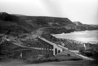
Figure 9.61. Building Sandsend Railway (1882) (© Whitby Museum)
The Whitby to Saltburn Railway provided access to intermediate points along the coast, such as Sandsend (Figure 9.62), Hayburn Wyke and Staithes. A short-lived scheme existed in the 1890s to lay out the high exposed cliff at Peak as a holiday resort, henceforth known as Ravenscar. The railway was the only practicable access, but was often impassable in winter. Over 1, 500 pliots were laid out and and some sold before the scheme finally foundered with the onset of the First World War (et al).
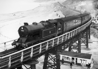
Figure 9.62. Locomotive train, Sandsend viaduct (1950s) (© Whitby Museum)
The main line of the Stockton & Darlington Railway is still operational but many of the ancillary lines have been abandoned and are now simple earthworks or have been reused as footpaths, some still with traces of sleepers and railbeds (Figure 9.63). Railways too are now old enough to have evidence for time-depth. When travelling by train people can see abandoned halts and viaducts. A number of important early bridges still survive e.g. Whitby Bridge.
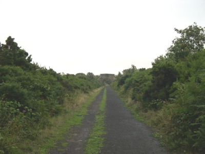
Figure 9.63. The former railway line at Ravenscar, now reused as a footpath
With motor traffic, roads previously rutted by horse-drawn carriages were resurfaced (Waters 2005, 21). Roads running along medieval and earlier lines display considerable evidence for time-depth: variously aged associated structures and furniture (toll-houses, wayside pubs and other services, bridges) alongside them. The integrated, almost organic approaches that older roads make to medieval settlements also nicely signify their age and underline the inextricable linkage between the historic and natural environments. The rapid expansion of the road network has also had a profound effect on the landscape of the 20th century. Pre-WWII motoring remains include garages, petrol stations, and road signage (Petts and Gerrard 2006, 194).
Trams were also a popular means of public and industrial transport (Waters 2005, 11). Cliff lifts were constructed to carry passengers up the face of steep cliffs (e.g. at Scarborough and Saltburn (Figure 9.64)) (Waters 2005, 17). They are popular with visitors who do not want to climb the alternative routes by steep steps, footpaths or roadways.
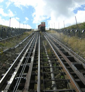
Figure 9.64. The cliff lift at Saltburn
Values and Perceptions
Cars now travel where once only walkers strolled, thus roads are for many people the outdoors they see most of, and the place from which passengers in particular (but also some drivers) appreciate many other HSC Types. Regular travellers develop particular affection or dread of particular bends or views. Railways provide more leisurely and elevated views over the historic landscape.
Access to cars has fundamentally changed patterns of contemporary life, including the spread of out-of-town shopping and leisure centres, the decline of local shops and the design of housing, with varying degrees of local impact (Petts and Gerrard 2006, 194).
Research, amenity and education
There has been extensive work on the 19th century railway network in this area, but little of note so far on 20th century railways, particularly for the period following the end of steam power. Nor has the impact of the many miles of new road constructed yet been assessed, nor the recording of its related infrastructure, for example bus shelters, petrol stations and road signage. In general it is only the earliest examples of such remains that have been researched or protected (Petts and Gerrard 2006, 189).
Much more useful research can be undertaken on early long distance routeways. Considerably more work has been done on railways although much of this is very particular and related to the mechanics and organisational detail. More could be done on the social and economic impact of railways in this area.
Communications are largely facilitators for the appreciation of other parts of the historic landscape but they do possess many interesting and beautiful features themselves. Bridges and viaducts may be the most dramatic but stations, roadside services and other infrastructure are also important and interesting elements in our landscape.
The new outstation of the National Railway Museum at Shildon (Co Durham) offers the potential for important collaborative projects on the rail system of the north east (Petts and Gerrard 2006, 194).
Condition & forces for change
Railways are an important aspect of the more recent heritage in this area, though the 20th century saw an on-going reduction in the extent of the network and the removal of trackside infrastructure (Petts and Gerrard 2006, 189).
Long-term continuities in the communication structure of this region have been little explored, yet the basic network of roads here appear to show significant levels of consistency over history (Petts and Gerrard 2006, 225).
This Type's importance lies as much in the way it takes people into and through the wider historic landscape as in the railway and road features themselves. In addition, the disused railway lines now provide good routes for public access along the coast, complementing the coastal footpaths.
The railways survive well, whether still operational or abandoned like some of the minor branches.
Roads are regularly upgraded and early features are often removed or obscured but the routes of most in the study area have not been significantly altered and travellers still experience the historic landscape from broadly the same line (if not at the same speed in some cases) as their medieval and early modern predecessors.
Construction of communication routes at or near the coast frequently involves major engineering projects, such as the building of roads in difficult or unstable coastal environments (eg Marine Drive, Scarborough), or of bridges across river estuaries. New projects may be necessitated not only by increased traffic to the coast, but also by the changing configuration of the coastline, rising sea-levels, or coastal defence initiatives. The direct impact of such projects, as on dryland, will be the removal or disturbance of archaeological remains in the areas of coast or foreshore affected by the route, and by associated construction operations. In addition, construction may also have indirect effects as a result of alterations to existing patterns of drainage, water flow in rivers, or tidal currents, thus creating the possibility of removal or exposure of sites through erosion (Fulford et al 1998, 205).
A Transport and Works order-making procedure has now been introduced, administered by the Department of Transport (DoT). Applications for orders must include an environmental statement and must notify Natural England and the Department of National Heritage if the work may affect an area covered by the restriction of wrecks act, and English Heritage if the work may affect a Scheduled Monument (Fulford et al 1998, 205-6).
Rarity and vulnerability
The Stockton & Darlington Railway was the world's first operational steam railway and should be considered of international importance.
The mundane nature of some of the surviving communication resources, coupled with constant redevelopment mean, however, that this infrastructure is increasingly threatened.
Recommendations
Retain main-line railways. Try to retain historic lines in future road improvements so that roads retain their integrity in the landscape. Bear in mind the importance of views over the historic landscape/seascape when designing changes to roads.
The relationship between prehistoric communications and Roman roads is poorly understood and further research into this could prove valuable (Petts and Gerrard 2006, 225).
The extent of the survival of transport-related features should be assessed in order to evaluate the threat to the resource and to direct further research and management decisions (Petts and Gerrard 2006, 192).
Sources
Fulford et al 1998. England's Coastal Heritage. A survey for English Heritage and the RCHME
Herring P, 1998. Cornwall's Historic Landscape. Cornwall Archaeological Unit, Truro
Morfin, J. Railways to the Yorkshire Coast in The Yorkshire Coast, edited by David B Lewis. Normandy Press, 1991
Petts, D and Gerrard, C, 2006. Shared Visions: The North East Regional Research Framework for the Historic Environment. Durham County Council
Waters, C, 2005. Then & Now. Scarborough. Tempus
