
England's Historic Seascapes: Scarborough to Hartlepool
Cornwall Council, 2007. https://doi.org/10.5284/1000201. How to cite using this DOI
Data copyright © Historic England unless otherwise stated
This work is licensed under the ADS Terms of Use and Access.


Primary contact
Charlie
Johns
Cornwall Council
Kennall Building, Old County Hall
Station Road
Truro
TR1 3AY
UK
Tel: 01872 322056
Resource identifiers
- ADS Collection: 744
- ALSF Project Number: 4731
- DOI:https://doi.org/10.5284/1000201
- How to cite using this DOI
Introduction | Seascapes Character Types
Water (fresh)
- Introduction: defining/distinguishing attributes and principal locations
- Historical processes; components, features and variability
- Values and perceptions
- Research, amenity and education
- Condition & forces for change
- Rarity and vulnerability
- Sources
Introduction: defining/distinguishing attributes and principal locations
The Type Water (fresh) includes the following sub-types:
- Watercourses (streams, non-navigable rivers);
- Springs;
- Ponds;
- Lakes.
Watercourses, running from the high moors inland, frequently dissect the coast along this shoreline. Numerous springs and ponds are also dotted along the cliffs along this stretch of coastline.
Historical processes; components, features and variability
In Yorkshire streams and brooks tend to be named 'becks' (eg Staithes Beck), a Middle English word that comes from the Old Norse bekkr. All tend to share similar characteristics of being fast flowing, oxygen rich, rain-fed and relatively unpolluted and these rich waters attract many kinds of flora and fauna (Figure 9.58).
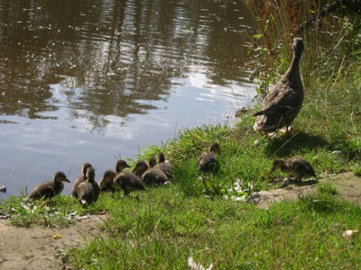
Figure 9.58. Ducklings on the bank of the River Esk
Apart from shelter, a good supply of freshwater has always been a key factor in settlement patterns and this holds true along this coastline, where settlements have grown up along the rivers and streams or close to springs.
Recent evidence from dried up channels of major rivers like the Thames suggests that prehistoric burial in rivers and lakes may have been the normal funeral rite in later Bronze Age and Iron Age Britain.
A description of the River Esk, reproduced from the Yorkshire Weekly Post by Bradley (1988):
'One of the most striking features of the Esk, considering that it is little over twenty miles in length from source to mouth, is its wide proportions in the lower reaches. This is not just in the estuary, but above the ordinary reach of the tides, which rarely flow beyond the weir at Ruswarp... .The Esk gathers strength from the high hills and mountains which enfold it in the whole length of its course, and the high moorlands and mountainous districts which border on Eskdale all drain into the river whose estuary forms Whitby Harbour..' (Bradley 1988, 3)
Watercourses have often been utilised to facilitate industry (eg corn mills, alum works, etc). Conversely settlement and industry can have detrimental effects on freshwater supplies, such as sewage contamination or waste from ironstone mines (that has discoloured many of the streams in this area).
Rivers and streams have also long been popular for recreation activities such as boating and angling (Figure 9.59).
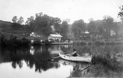
Figure 9.59. Boating at Ruswarp, River Esk (© Whitby Museum)
Angling on the Esk is highly regarded, with salmon, sea trout and brown trout being abundant.
'If you stand at Whitby Station any night when the freshets are on and see train after train disgorge its small contingent of anglers, each with a string of salmon thrown over his shoulder or a heavily-laden fishing bag, you will be satisfied that catches are made in actuality, and not in the corner of one's favourite smoke-room with an imaginative rod and line and a whiskey-inspired cast of flies' (Bradley 1988, 24)
The water in some parts of this study area is also renowned for being rich in beneficial minerals. In 1626 a stream of acid water was discovered running down from one of the cliffs to the south of the town of Scarborough. The medicinal benefits of the water were soon discovered and by the 1690s the wells were famous and Scarborough had made its first steps not only as a Spa town but as the original English seaside resort. The strong mineral content of the water is readily apparent in the staining caused to the stone, the reason why the waters were originally discovered as they trickled over the rocks and stones somewhere near this site.
Values and Perceptions
Anglers will always value those rivers where they had success. Most people will appreciate the beauty and the wildlife value of the water bodies.
Research, amenity and education
They have a high recreational value.
Condition & forces for change
Water supply is for the most part a matter for inland areas, but there are particular concerns at the coast about the discharge of water and sewage, and the maintenance of water quality.
The effect of water quality (pollution) on archaeological resources may be a factor for the preservation of terrestrial, inter-tidal, and submerged archaeological sites. Pollution alters the chemical composition of water and soil, often making them more acidic and thus more likely to damage any archaeological remains they come into contact with. However, very little research has been carried out on water pollution and its effect on archaeological sites (Fulford et al 1997, 206).
Throughout the region, the Environment Agency (EA) has prepared a series of Local Environment Action Plans (LEAPs) for the major river catchments (i.e. Tees, Wear and Tyne). The aim of the Plans, is to identify, prioritise and cost environmentally beneficial actions which the EA and partners will work together to deliver. This will be achieved by focusing attention of interested parties in planning for the future for the environment of a specific area and establishing an integrated plan of action for managing the local environment over five years.
Rarity and vulnerability
The Esk in particular is of regional importance for the quality of its salmon and trout fishing.
Recommendations
More historical work could be done on the development of freshwater fishing.
Sources
Publications:
Allen, T, 2000. British Archaeology 54
Bradley, T, 1988. The Esk
Fulford, N, Champion, T and Long, A (eds), 1997. England's Costal Heritage: a survey for English Heritage and the RCHME. RCHME and English Heritage Report 15
Websites
www.defra.gov.uk/erdp/pdfs/programme/ne/section1_2.pdf
