
Smart Street, Ipswich - IAS5701
Suffolk County Council Archaeological Service, 2015. https://doi.org/10.5284/1034363. How to cite using this DOI
Data copyright © Suffolk County Council Archaeological Service unless otherwise stated
This work is licensed under the ADS Terms of Use and Access.

Primary contact
Suffolk County Council Archaeological Service
Bury Resource Centre
Hollow Road
Bury St Edmunds
IP32 7AY
Resource identifiers
- ADS Collection: 1929
- DOI:https://doi.org/10.5284/1034363
- How to cite using this DOI

Introduction
Circumstances of excavation
Ipswich Borough Council, as owners of the site, commissioned the excavation so that the land could be sold for residential development free of archaeological constraints.
Site constraints
The parcel of land was a Scheduled Monument (Suffolk County no.190) and Ipswich Borough Council obtained scheduled monument consent for the excavation and subsequent development from the Secretary of State for the Environment.
During the mechanical soil stripping, it was clear that Victorian basements had destroyed up to 75% of the northern half of the Foundation Street frontage (up to 6m back from the pavement) and this was not excavated. A strip was also left unexcavated at the south end to safeguard the standing properties to the south of the site from potential damage.
Site summary
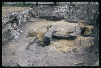
Eight pits and probably one well (0026) were attributed to the Middle Saxon period (MS: c.700-c.850). The roughly oval well pit was over 3.2m wide at the top, tapering to 1.8m at its base, and 3.1m deep. The timber well shaft comprised a circle, 50cm in diameter, of individually split oak planks surviving up to 80cm high above the bottom of the well.
Sixteen pits, one well (0053) and a hearth (0249) were identified as Early Late Saxon (ELS: c.850-900). The almost vertical well pit was1.9m diameter at the top, tapering to 1.45m at its base, and 3.2m deep. The shaft had two separate linings. The upper lining, a hollowed-out oak trunk, 90cm in diameter, survived to within 2.2m of the top of the feature and was recovered in a number of separate pieces with all wood shown as 0254 on the general plan. Below this tree trunk lining, there was a ring of staves, of narrower diameter forming a lower lining. The staves had all been cut to shape, although stave 0090 had the addition of a half lap joint, with a peg hole at one end, which had been found facing downwards in the fill at the base of the shaft. Of the sixteen pits, six pits were inter-cutting and in a line running from north to south across the site. A hearth (0249) comprising a gravel base overlain with fired clay, and probably domestic, lay in the south-west corner of the site.
A sunken featured building (0062), eleven rubbish pits and a possible well (0041) belonged to the Middle Late Saxon period (MLS: c.900-1000). Some intercutting of pits was recorded indicating more than one phase of activity.
The medieval period was also represented by pits with 22 belonging to the Early Medieval (EMED: c.1000-1200); 8 to the Late Medieval (LMED: c.1200-1450) and 3 to the Late Medieval Transitional period (c.1450-1600)
Two brick lined wells, two soakaways, a pit (and the residue of a brick lined cellar) were all associated with the Victorian terraced housing which fronted Foundation Street.
Further information can be found in the Site Summary which can be accessed by selecting the 'Reports' tab on the 'Downloads' page.
