
Shire Hall Yard, Ipswich - IAS6904
Suffolk County Council Archaeological Service, 2015. https://doi.org/10.5284/1034370. How to cite using this DOI
Data copyright © Suffolk County Council Archaeological Service unless otherwise stated
This work is licensed under the ADS Terms of Use and Access.

Primary contact
Suffolk County Council Archaeological Service
Bury Resource Centre
Hollow Road
Bury St Edmunds
IP32 7AY
Resource identifiers
- ADS Collection: 1936
- DOI:https://doi.org/10.5284/1034370
- How to cite using this DOI

Introduction
Circumstances of excavation
Planning permission was granted for a northern extension to the Eastern Counties Omnibus Company Ltd premises, in Pleasant Row/Shirehall Yard, as part of the Stoke Bridge and Approaches road scheme. The Suffolk Archaeological Unit excavated the site from December 1981 to January 1982.
Site constraints
The area was scheduled as an Ancient Monument (Suffolk County Monument No.189b). Scheduled Monument Consent was granted for development subject to prior archaeological excavation.
Site summary
Although 183 sq m was opened up, only the 100 sq m west of the Blackfriars’ precinct wall was hand excavated leaving the area to the east (the town ditch) unexcavated.
A curving ditch, 2.4m wide and 80cm deep, ran across the south-west corner of the site. The base was silted with gravel and the upper half with sand. Only one sherd of Romano-British greyware was recovered but there were another 107 similar sherds residual in other features.
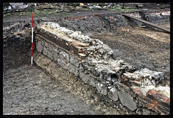
There were four pits dating to the Middle Saxon period (MS: c.700-850) at the north-west of the site. There were no certain structures of this date, but a group of postholes in the north-west corner of the site was probably part of a structure of later Middle Saxon or Early Late Saxon date. One large pit of Early Late Saxon (ELS: c.850-900) origin lay at the west end of the site and north-east of this there was a 3m length of foundation trench running through the MS/ELS posthole group. A large north-south ditch, which was MLS in date on the School Street site (IAS4801) only 150m to the north, is, without doubt, the Late Saxon town ditch although the pottery assemblage was ELS. There was no evidence of MLS occupation and not one sherd of St Neot's ware from the entire site. The east side of the ditch had been removed by the cutting of the Late Medieval town ditch, but it was at least 5m wide and 2m deep if the half width (to the lowest point) is doubled.
Two north-south linear features: the town ditch and the precinct wall of the Dominican Friary were dated as Late Medieval (LMED: c.1200-1450). One large pit and a 1.7m length of brick wall belonged to the Late Medieval Transitional period (LMT: c.1450-1600). Traces of buildings, which had fronted Pleasant Row during the Post Medieval period (PMED: c.1600-1900), included two cellars, a system of drainage pipe trenches with an inspection chamber and building fragments. In addition, the eastern face of the Friary precinct wall had been lined with a brick face.
Further information can be found in the Site Summary which can be accessed by selecting the 'Reports' tab on the 'Downloads' page.
