
Parsonage Farm, Westwell, Kent - Integrated Site Report
Museum of London Archaeology, 2009. (updated 2017) https://doi.org/10.5284/1044817. How to cite using this DOI
Data copyright © High Speed 1 unless otherwise stated
This work is licensed under the ADS Terms of Use and Access.

Primary contact
Stuart
Foreman
Senior Project Manager
Oxford Archaeology (South)
Janus House
Osney Mead
Oxford
OX2 0ES
UK
Tel: 01865 263800
Fax: 01865 793496
Resource identifiers
- ADS Collection: 2461
- DOI:https://doi.org/10.5284/1044817
- How to cite using this DOI

Introduction
The Museum of London Archaeology Service (MoLAS) was commissioned by Union Railways (South) Limited (subsequently London and Continental Railways) to undertake a detailed excavation to the west of Station Road near Westwell, Kent. Excavation in advance of the construction of the Channel Tunnel Rail Link (CTRL) at Parsonage Farm (NGR TQ 598050 146050), uncovered evidence for a medieval farm or manor. A brushwood platform of late pre-Roman Iron Age or early Roman date was also partially uncovered on the bank of a nearby stream.
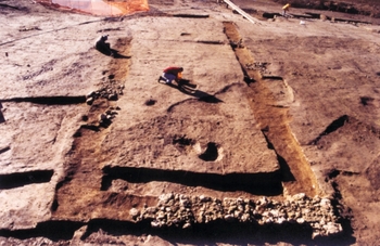
The medieval site occupied the southern end of a low spur of land bounded to the south and east by streams. Its occupation was of three phases. A small area of the earliest, Phase 1 activity, comprising a timber building and associated linear ditch of late 12th-century date, was uncovered close to the eastern stream. In the late 12th or early 13th centuries the site was redeveloped (Phase 2). A timber hall measuring c 18.8 m by 7 m, whose main frontage faced north-east, was constructed. The hall was of four bays: that at the north-western end was partitioned off and is likely to have formed the service end of the building. Ancillary timber buildings, probably including a kitchen, lay to the rear of the hall. During the lifetime of the hall a masonry-founded cross-wing was constructed at its south-eastern end. Its position at the other end of the hall to the service bay suggests that the building housed private chambers on the first floor, but evidence for its status is limited to a few fragments of moulded stone, which may in any event derive from the later remodelling of the wing.
Around the middle of the 13th century, or slightly later, the hall was completely reconstructed (Phase 3), on the same plot and alignment but on grander lines as an aisled structure measuring 21.5 m by 9.8 m. The north-western service bay may now have been separated from the three bays of the hall proper by a narrow passage. At this point the two streams bounding the site were remodelled to form, for the first time, a moat that completely surrounded the building complex. The ancillary buildings to the rear of the hall were also rebuilt on a reconstructed platform with masonry and timber revetting at its southern, moat end. After these works were completed, the solar wing was modified and an extension built on to its eastern side.
The scale of the hall, the masonry solar wing and the quality of many of the finds attest to the high status of the site by the end of Phase 2 and during Phase 3, and no doubt reflect the wealth of the rector (parson) of Westwell at that date. Although the archaeological evidence indicates that the buildings were dismantled and removed so that little trace of their fabric, other than large quantities of ceramic roof tile, remained on site, it also suggests that occupation continued into the 14th century and possibly as late as AD 1380. The rectory was appropriated to Canterbury Cathedral in 1397. Subsequently Parsonage Farm was leased out to farmers and perhaps not occupied until the new farm was built across the road in the 16th century.
Late and post-medieval occupation could not be coherently defined archaeologically and may have been ephemeral in nature, although a 19th-century smithy was uncovered outside the northern moat.
The fieldwork events incorporated in this report are:
- West of Parsonage Farm Watching Brief - Area 430 (ARC WB430/84+900-85+100) - Watching Brief
- Parsonage Farm (ARC PFM98) - Excavation
- Parsonage Farm Watching Brief - Area 430 (ARC WB430/85+100-85+350) - Watching Brief
