
Sandway Road, Lenham, Kent - Integrated Site Report
Wessex Archaeology, Oxford Archaeology (South), 2009. (updated 2017) https://doi.org/10.5284/1044813. How to cite using this DOI
Data copyright © High Speed 1 unless otherwise stated
This work is licensed under the ADS Terms of Use and Access.

Primary contact
Stuart
Foreman
Senior Project Manager
Oxford Archaeology (South)
Janus House
Osney Mead
Oxford
OX2 0ES
UK
Tel: 01865 263800
Fax: 01865 793496
Resource identifiers
- ADS Collection: 2456
- DOI:https://doi.org/10.5284/1044813
- How to cite using this DOI


Downloads
Post-Excavation Assessment
Reports
| Project Area 420 Archaeological Excavation at Sandway Road (ARC SWR99), near Sandway, Kent. Detailed Archaeological Works Assessment Report - Final (SWR_PXAssessment_combined.pdf) |
3 Mb | |
| Project Area 420 Archaeological Excavation at Sandway Road (ARC SWR99), near Sandway, Kent. Detailed Archaeological Works Assessment Report - Final (SWR_PXassessment_text.pdf) |
1 Mb | |
| Figure 1 (SWR_PXAssessment_Fig001.pdf) |
3 Mb | |
| Figure 2: Sanday Road results (excluding geophysics results) (SWR_PXAssessment_Fig002.pdf) |
291 Kb | |
| Figures 3 - 9: Figure 3: Worked Flint typological breakdown - Total Assemblage; Figure 4: Worked Flint typological breakdown - Artefact Scatter 137 (no tools present); Figure 5: Worked Flint typological breakdown - Artefact Scatter 144; Figure 6: Worked Flint typological breakdown - Pit 167; Figure 7: Worked Flint typological breakdown - Pit 72; Figure 8: Percentage of Worked Flint Artefacts by Depth and Figure 9: Percentage of Worked Flint Tools by Depth (SWR_PXAssessment_Fig003.pdf) |
205 Kb | |
| Figure 10: Comparative distributions of worked and burnt flint from Mesolithic features 72, 137 and 144 (SWR_PXAssessment_Fig010.pdf) |
399 Kb | |
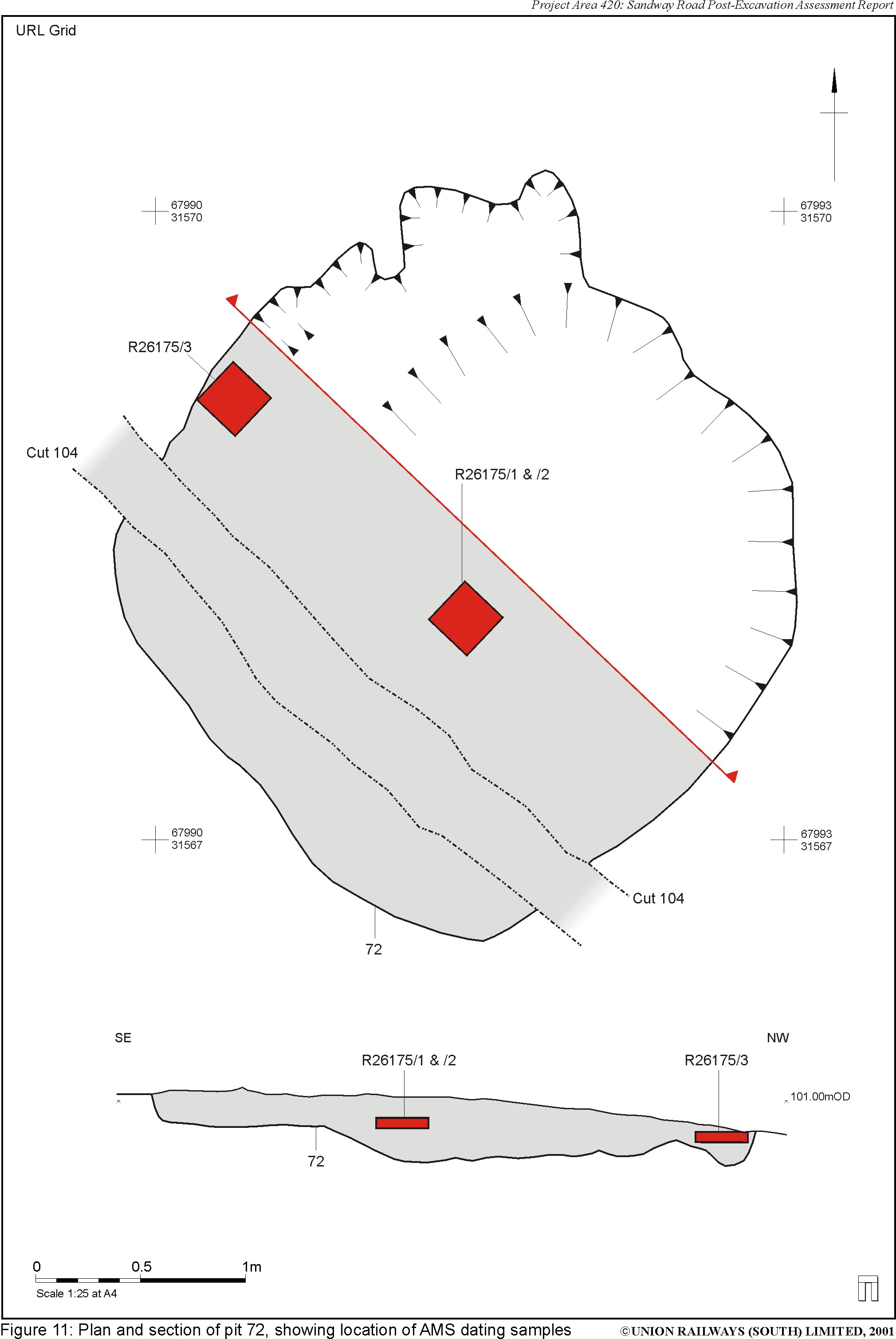
| Figure 11: Plan and section of pit 72, showing location of AMS dating samples (SWR_PXAssessment_Fig011.pdf) |
36 Kb |
Spreadsheets
| SWR_PXassessment_site_data | ||
| Archive (Site Data) | CSV | 1 Kb |
| Bulk (Site Data) | CSV | 13 Kb |
| Context (Site Data) | CSV | 24 Kb |
| Environmental (Site Data) | CSV | 12 Kb |
| Event (Site Data) | CSV | 5 Kb |
| Finds (Site Data) | CSV | 3 Kb |
| Graphical (Site Data) | CSV | 13 Kb |
| Group (Site Data) | CSV | 1 Kb |
| Phase (Site Data) | CSV | 1 Kb |
| Site (Site Data) | CSV | 1 Kb |
| Sub-group (Site Data) | CSV | 320 Kb |
| SWR_PXAssessment_specialist_data | ||
| Burnt Flint (Specialist Data) | CSV | 4 Kb |
| CBM (Specialist Data) | CSV | 1 Kb |
| Fired Clay (Specialist Data) | CSV | 1 Kb |
| Flint (Specialist Data) | CSV | 143 Kb |
| Flint Tools (Specialist Data) | CSV | 1 Kb |
| Metal (Specialist Data) | CSV | 1 Kb |
| Pottery (Specialist Data) | CSV | 5 Kb |
| Stone (Specialist Data) | CSV | 1 Kb |
Drawings
|
Figure 1: Site location plan with geophysical survey results (SWR_PXAssessment_Fig001) |
364 Kb | |
| DXF | 3 Mb | |
| DWG | 512 Kb | |
|
Figure 2: Sandway Road results (exclusing geophysics results) (SWR_PXAssessment_Fig002) |
531 Kb | |
| DXF | 811 Kb | |
| DWG | 145 Kb |
Images
 as a JPG image")
|
Figure 11: Plan and section of pit 72, showing location of AMS dating samples (SWR_PXAssessment_Fig011.jpg) |
JPG | 353 Kb |
