
Ager Tarraconensis Field Survey Project
S J Keay, Martin Millett, 2003. https://doi.org/10.5284/1000351. How to cite using this DOI
Data copyright © Prof S J Keay, Prof Martin Millett unless otherwise stated
This work is licensed under the ADS Terms of Use and Access.


Primary contact
Prof
Martin
Millett
Faculty of Classics
University of Cambridge
Sidgwick Avenue
Cambridge
CB3 9DA
England
Tel: 01223 337733
Resource identifiers
- ADS Collection: 355
- DOI:https://doi.org/10.5284/1000351
- How to cite using this DOI


Introduction
This archive is one of a number of key records submitted to the Archaeology Data Service as part of the ARENA project. ARENA is concerned with conservation and presentation of the European archaeological heritage through new information technologies. This project is carried out with the support of the European Community through the Culture2000 programme and has six partner organisations in Poland, Romania, Denmark, Iceland, Norway and the United Kingdom. The lead partner in the project is the Archaeology Data Service which is the Arts and Humanities Data Service Centre for Archaeology and is located at the Department of Archaeology at the University of York in the UK.
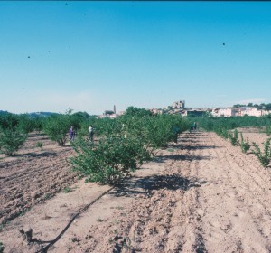
Fieldwalking in Ager Tarraconensis 1990
The Ager Tarraconensis archive represents data from a survey conducted between 1985 and 1990 in the territory of Tarragona in Spain. The survey used field-walking techniques to investigate the development of the classical landscape in the hinterland of Tarraco, the Roman provincial capital of Hispania Citerior (Tarraconensis). The survey demonstrated that the analysis of pottery scatters can make a positive contribution to a study of the relationship between Tarragona and its hinterland in antiquity. The evidence showed that the Roman landscape was heavily populated and densely exploited and also showed a predominence of smaller farmsteads over villas. The project was published in 1995 as a Journal of Roman Archaeology supplement.
The methodology used was designed to be systematic, it used two sets of methods. One to analyse distributions of finds so as to identify potential settlement sites in order to facilitate comparisons between periods and two to make inter-site comparisons of field-survey pottery assemblages. The methodolgy was also designed to investigate potential bias caused by field-walking in different environmental conditions such as varied natural light.
The Archive
The archives from the Ager Tarraconensis project consist of:
- A data base containing the documentary record of each field (campo) recorded, and the documentary record outlining the method of survey in each field and the conditions at the time of survey.
- A set of plans showing transects accross the landscape used to sample the region. These transects also have a sets of maps showing the location of each field contained in the data base above. Lastly the archive contains and a set of maps showing the fields walked shaded according to pottery types. The transects can be accessed through the connection above as can a map showing the location of the sites discovered by the survey.
