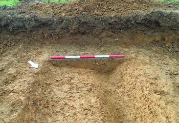
Data from a Trial Trench Evaluation at Kings Pond Cottages, Buckinghamshire, 2019 (HS2 Phase One)
High Speed Two Ltd., INFRA Archaeology, 2024. https://doi.org/10.5284/1119068. How to cite using this DOI
Data copyright © High Speed Two Ltd. unless otherwise stated
This work is licensed under a The Open Government Licence (OGL).
Primary contact
High Speed Two Ltd.
2 Snowhill
Queensway
Birmingham
B4 6GA
United Kingdom
Tel: 08081 434 434
Resource identifiers
- ADS Collection: 4450
- DOI:https://doi.org/10.5284/1119068
- How to cite using this DOI
Introduction

This collection comprises site data (digital photographs, reports, scanned trench and context sheets, registers and drawings) from a trial trench evaluation by INFRA Archaeology on land at Kings Pond Cottage, near Great Missenden, Buckinghamshire. The evaluation, comprising 19 trenches, was undertaken during February 2019.
Project Summary
The evaluation forms part of Phase One of the High Speed 2 (HS2) rail project, which will involve the construction of a new railway approximately 230km (143 miles) in length between London and the West Midlands. Powers for the construction, operation and maintenance of Phase One are conferred by the High-Speed Rail (London - West Midlands) Act 2017.
The aims of the trial trenching were to:
- Confirm the presence/absence, extent and depth of any surviving archaeological remains within the Site
- Determine the nature, date, condition, state of preservation, complexity and significance of any archaeological remains
- Determine the likely range, quality and quantity of artefactual and environmental evidence present
- Suggest measures, if appropriate and feasible, for further archaeological investigation to mitigate identified significant impacts
The evaluation also contributed to the delivery of the following GWSI: HERDS Specific Objectives:
- KC5: Identifying settlement location and developing models for settlement patterns for the Mesolithic, Neolithic and Early Bronze Age.
- KC34: Undertake research and investigation into medieval manorial complexes. What was their origin, development and impact on the landscape?
- KC40: Identify patterns of change within medieval rural settlement from the 11th to mid-14th century.
Of the 19 trenches excavated, 7 contained archaeological features, including 2 pits and 8 linear features interpreted as field boundaries and drainage ditches. The results of the evaluation identified agricultural exploitation, likely removed from a settlement. Only one feature was able to be dated with any certainty, a field boundary ditch from the late 13th to early 15th century.
Further work on the site is recommended as it could clarify the extent of the linear features and pits identified during this evaluation, and hopefully provide further dating evidence for these features. This could take the form of a small-scale open-area excavation targeted on the area south of centre where the evaluation detected a slightly increased concentration of features. Any further work, or other archaeological interventions in the immediate area, would benefit from the results and data provided by this archive.
Re-Use Value Statement
The results of the evaluation on land at Kings Pond Cottage identified agricultural exploitation, likely removed from a settlement. Only one feature was able to be dated with any certainty, a field boundary ditch from the late 13th to early 15th century.
Further work on Site is recommended as it could clarify the extent of the linear features and pits identified during this evaluation, and hopefully provide further dating evidence for these features. This could take the form of a small-scale open-area excavation targeted on the area south of centre where the evaluation detected a slightly increased concentration of features. Any further work, or other archaeological interventions in the immediate area, would benefit from the results and data provided by this archive.


