
Images from a Building Recording Survey of the Rugby Radio Station Masts at DIRFT III, Northamptonshire July 2014
Cotswold Archaeology, 2022. https://doi.org/10.5284/1100080. How to cite using this DOI
Data copyright © Cotswold Archaeology unless otherwise stated
This work is licensed under a Creative Commons Attribution 4.0 International License.

Primary contact
Cotswold Archaeology
Building 11
Kemble Enterprise Park
Cirencester
GL7 6BQ
UK
Tel: 01285 771022
Fax: 01285 771033
Resource identifiers
- ADS Collection: 4758
- DOI:https://doi.org/10.5284/1100080
- How to cite using this DOI
Introduction
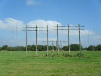
This collection comprises images from a building recording survey of the remaining radio masts at the site of the former Rugby Radio Station to the east of Watling Street (A5), within the Northamptonshire County boundary. The survey recorded the part of the site that lies within the area designated for the development of Daventry International Rail Freight Terminal (DIRFT III). Work was commissioned by CgMs Consulting and was carried out by Cotswold Archaeology in July 2014 in accordance with the English Heritage guidelines for a Level I survey.
The masts in this area were erected in the 1950s to support the antennas for the new radio station ('B' Building) that was built to cater for the increased demand for radio telephone transmission in the post-war years. At this time, with fifty-seven transmitters, the former Rugby Radio Station was the largest radio transmitting station in the world. The survey recorded forty-three masts of three types (Types I, II and III) still standing within the site; reference to historic mapping shows that many of the masts, particularly in the northern part of the site, have been removed. A variety of timber pylons associated with the former radio station was also recorded.
