Data from an Archaeological Monitoring at Three Bears Cottage, South Heath Cutting, Buckinghamshire, 2021 (HS2 Phase One)

High Speed Two Ltd., INFRA Archaeology, 2023. https://doi.org/10.5284/1124524. How to cite using this DOI

Digital Object Identifiers

Digital Object Identifiers (DOIs) are persistent identifiers which can be used to consistently and accurately reference digital objects and/or content. The DOIs provide a way for the ADS resources to be cited in a similar fashion to traditional scholarly materials. More information on DOIs at the ADS can be found on our help page.

Citing this DOI

The updated Crossref DOI Display guidelines recommend that DOIs should be displayed in the following format:

https://doi.org/10.5284/1124524
Sample Citation for this DOI

High Speed Two Ltd., INFRA Archaeology (2023) Data from an Archaeological Monitoring at Three Bears Cottage, South Heath Cutting, Buckinghamshire, 2021 (HS2 Phase One) [data-set]. York: Archaeology Data Service [distributor] https://doi.org/10.5284/1124524

Data copyright © High Speed Two Ltd. unless otherwise stated

This work is licensed under a The Open Government Licence (OGL).


High Speed Two Ltd. logo

Primary contact

High Speed Two Ltd.
2 Snowhill
Queensway
Birmingham
B4 6GA
United Kingdom
Tel: 08081 434 434

Send e-mail enquiry

Resource identifiers

Digital Object Identifiers

Digital Object Identifiers (DOIs) are persistent identifiers which can be used to consistently and accurately reference digital objects and/or content. The DOIs provide a way for the ADS resources to be cited in a similar fashion to traditional scholarly materials. More information on DOIs at the ADS can be found on our help page.

Citing this DOI

The updated Crossref DOI Display guidelines recommend that DOIs should be displayed in the following format:

https://doi.org/10.5284/1124524
Sample Citation for this DOI

High Speed Two Ltd., INFRA Archaeology (2023) Data from an Archaeological Monitoring at Three Bears Cottage, South Heath Cutting, Buckinghamshire, 2021 (HS2 Phase One) [data-set]. York: Archaeology Data Service [distributor] https://doi.org/10.5284/1124524

INFRA Archaeology logo

Overview

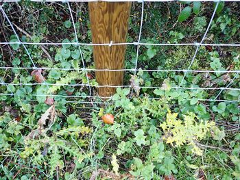
Example of completed fence post and its relationship to the soil horizon Copyright HS2 Ltd.

Re-use Value Statement

The Archaeological Monitoring was undertaken on the excavation of 12 fence posts, these were installed to the eastern edge of the Site and the works did not intrude into the Scheduled protection area. All of the monitored fence posts were excavated to a depth that penetrated into the underlying geological substrate.

The proximity of the Site to the Grim's Ditch Scheduled Monument and to known archaeological activity recorded to the east meant that there was potential for the fencing works to encounter archaeological deposits.

Despite the potential of the Site, no archaeological deposits were identified, and no finds were recovered.

Although no archaeological deposits were identified, the relatively small sample size of the monitored fence posts should be noted however.

The negative results of the monitoring works do not contribute to informing HERDS objectives for the Site, and no further monitoring is required in the area of the fencing works.

Due to the lack of results and very constrained area of analysis the dataset presented here does not help answer wider research framework questions, and does not add to the wider archaeological work completed in this area.


ADS logo
Data Org logo
University of York logo