
ACCORD: Archaeology Community Co-production of Research Data
Stuart Jeffrey, Alex Hale, Cara Jones, Mhairi Maxwell, Siân Jones, 2017. https://doi.org/10.5284/1042733. How to cite using this DOI
Data copyright © ACCORD project unless otherwise stated
This work is licensed under the ADS Terms of Use and Access.

Primary contact
Dr
Stuart
Jeffrey
Research Fellow
Glasgow School of Art
Digital Design Studio
The Hub
Pacific Quay
Glasgow
G51 1EA
Scotland
Tel: +44 (0) 141 566 1465
Resource identifiers
- ADS Collection: 1963
- DOI:https://doi.org/10.5284/1042733
- How to cite using this DOI

Overview
|
ACCORD Research Aims
Expert forms of knowledge and/or professional priorities, rather than community ones, have to date informed the vast majority of digital recording and visualisation activity. Consequently the resulting outputs can be difficult to access and re-use and may seem disconnected, clinical, and irrelevant to non-professional communities of interest. Furthermore these technologies have so far failed to engage communities as a means of researching and representing their heritage. In addition digital records and visualisations have rarely integrated any form of community-based social value relating to the historic environment. Such data has the potential to increase both the perceived authenticity and the value of the digital outputs, including academic value.
The ACCORD project sought to further understand the uses and value of digital visualisation technologies in community heritage activities and research. The research questions were:
- What are the barriers to digital 3D recording and modelling technologies in the domain of community heritage?
- How are forms of existing community-based social value and significance associated with heritage sites and places addressed and transformed through engagement with 3D digital technologies?
- How does the co-design and co-production of 3D records and models change peoples’ relationship to heritage sites? For example, does it allow people a different or enhanced sense of ownership over their heritage?
- How are the results engaged with by the community partners? For what purposes or in what contexts are they considered useful or valuable?
- Are the co-produced results considered to be authentic? What forms of significance do these 3D models acquire?
In order to address the above questions, a series of focus groups were held with each group of community partners, and then together with the project team photogrammetry, Reflectance Transformation Imaging (RTI), and in some cases terrestrial LiDAR, were deployed to record sites/ places/ objects chosen by the community partners. The digital outputs from each project were integrated with expressions of community-based social value and additional contextual information such as old photographs, stories and memories. An archive of this material has been deposited with the Archaeology Data Service under a CC-BY license, meaning they are free for all forms of re-use as long as the community group and the ACCORD project are given attribution as the original data creators.
A full description of the ACCORD methodology has been published in the Proceedings of the CAA: Jeffrey, S., Hale, A., Jones, C., Jones, S., Maxwell, M. 2015. The ACCORD project: Archaeological Community Co-Production of Research Resources. In (2015) F. Giligny, F. Djindjian, L. Costa, P. Moscati and S. Robert, Eds., Concepts, methods and tools. Proceedings of the 42nd Annual Conference on Computer Applications and Quantitative Methods in Archaeology, Paris, April 2014, Archaeopress, I SBN 978-1-78491-100-3, ISBN 978-1-78491-101-0, http://www.archaeopress.com/Public/download.asp?id={5CACE285-4C48-41AE-809E-E98B65C9E4CD}.
A discussion of the participatory process of making 3D digital visualisations of heritage and its power as a medium for inclusion, exploration and expression has been published in Internet Archaeology: Maxwell, M. (2017). Power is in the Process: The ACCORD project, Internet Archaeology 44. https://doi.org/10.11141/ia.44.10.
Project Partners
- Dr Stuart Jeffrey – Digital Design Studio (DDS), Glasgow School of Art (PI)
- Prof Sian Jones – University of Manchester (Co-I)
- Dr Alex Hale – the Royal Commission for Ancient and Historical Monuments in Scotland (RCAHMS) (Co-I)
- Cara Jones – Archaeology Scotland (ACCORD project partner)
- Dr Mhairi Maxwell – ACCORD project Post-Doctoral Research Assistant
- Archaeology Data Service
Community Partners
- The Colintraive and Glendaruel Development Trust (http://cgdt.org/), Argyll.
- The Friends of the Glasgow Necropolis (http://www.glasgownecropolis.org/), City of Glasgow.
- Climbers at Dumbarton Rock (an informal community of interest http://www.dumby.info/), Dumbartonshire.
- The Access Archaeology group (https://www.facebook.com/pages/Access-Archaeology/220567611416105?fref=ts), the Uists, Western Isles.
- Ardnamurchan Community Archaeology Group, Highlands.
- The Rhynie Woman group (https://www.facebook.com/RhynieWomanOnline?fref=ts), Aberdeenshire
- The How Old Are Yew? group (https://www.facebook.com/events/633171993413744/?fref=ts), Castlemilk, City of Glasgow.
- Kirkcudbright History Society (http://www.kirkcudbrighthistorysociety.org.uk/), Dumfries and Galloway.
- Bressay History Group, Shetland Isles.
- Tarbet Isle Project, Tarbet, Argyll.
ACCORD Technical Information
Where possible, low-cost or free software was used by ACCORD:
- Photogrammetry –Agisoft Photoscan standard edition stand-alone license. Version 1.0.2.1824.
- Image manipulation – Gimp 2 (free). Version 2.8.
- 3D dissemination - Adobe Acrobat 3D PDF (free). Version 11.0.09.
- RTIbuilder – available at the Cultural Heritage Imaging website (free). Version 2.0.2. (http://culturalheritageimaging.org/What_We_Offer/Downloads/Process/)
- RTIviewer – available at the Cultural Heritage Imaging website (free). Version 2.0.2. (http://culturalheritageimaging.org/What_We_Offer/Downloads/Process/)
Photogrammetry
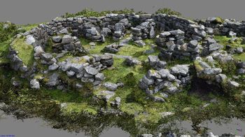
Photogrammetry is a digital 3D visualisation technology based in the principles of photography and trigonometry. Often a range of cameras, smartphones, tablets were used in the data-capture as part of the ACCORD co-production methodology. Processing used Agisoft photoscan software. All images were captured as high resolution JPEGs, aligned at high accuracy and generic pair selection. Sometimes visual markers were required for manual image alignment. A dense point cloud was then generated at medium or high quality. An arbitrary high polygon count surface mesh was then generated using the dense point cloud data. These meshes were then textured using the original JPEG images with generic and mosaic settings.
These models are available in 3D PDF format as well OBJ format (with associated material files), where avaiable X3G (3D print files) formats are also available from individual project pages.
Three-dimensional printing
Many of the models generated as part of ACCORD were 3D printed from exported Agisoft photoscan in OBJ format. The project used a Makerbot Replicator 2 printer which prints in PLA plastic. 3D print ready files are available for a number of the photogrammetric and LiDAR models created by the communities with ACCORD. They are provided in OBJ format, but in some cases as X3G and THING formats are available.
Reflectance Transformation Imaging (RTI)
Reflectance Transformation Imaging (RTI) is an interactive digital imaging tool based in photography. Data collection consisted of digital images captured using an 18-55mm Nikkor lens on a Nikon D5300 DSLR camera in controlled lighting conditions. Before any images were taken, the camera and lens settings were fixed so that each image was taken with the same focus (with no flash and images captured as high resolution JPEG) using a remote shutter release to minimise camera shake. A series of digital images were taken from a fixed position using the highlight capture technique; a static highly reflective black sphere is captured in each frame. To minimise the interference of daylight data capture sometimes took place under a tarpaulin. We used the highlight based data capture technique, requiring hand-held light sources, and processed our images using the RTI builder software available from Cultural Heritage Imaging and a polynomial texture mapping (PTM) plugin. The software RTI Builder was used to combine images into one file, which can then be viewed using the free to download RTI viewer.
Terrestrial Laser Scanning
For some projects ACCORD also used time of flight laser scanning, this requires expensive hardware and proprietary software to capture the data. Equipment was supplied through the project’s lead institution, the Glasgow School of Art and operated by Alastair Rawlinson, Head of Visualisation at the school’s Digital Design Studio. For reasons of equipment cost and the specialist knowledge required for the use laser scanners, it was not a preferred technology as part of ACCORD’s co-production process for most projects.
- Hardware used - Leica C10
- Scan data processing – Leica Cyclone
- Scan data processing and modelling - Blender, Meshlab (both open-source freeware)
Data available from the ADS
The co-produced digital outputs of the ACCORD project are archived here in folders arranged by sub-project, named after each community group. Each folder is comprised of digital images in JPEG format, 3D digital models of a range of monument types in PDF and OBJ format (from which 3D prints can be generated), RTI files in PTM format of a range of monuments and associated metadata in a spreadsheet file. Digital documents (co-written summary statements and blog articles written by community participants originally published on https://accordproject.wordpress.com) are also included in the archives.

All ACCORD datasets provided via the ADS are licensed under a Creative Commons CC BY 3.0 license
