
Croome Court, High Green, Worcestershire Archaeological Observation
Border Archaeology, 2019. https://doi.org/10.5284/1050908. How to cite using this DOI
Data copyright © Border Archaeology unless otherwise stated
This work is licensed under a Creative Commons Attribution 4.0 International License.

Primary contact
Border Archaeology
The Plaza
Owen Way
Leominster Enterprise Park
Leominster
HR6 0LA
UK
Resource identifiers
- ADS Collection: 3353
- DOI:https://doi.org/10.5284/1050908
- How to cite using this DOI

Introduction
Border Archaeology Ltd (BAL) carried out an archaeological observation of trenching excavations relating to a new heating system at Croome Court High Green Severn Stoke Worcestershire. With the exception of a small brick-built drain or culvert, no features of significance were present on the south side of the house.
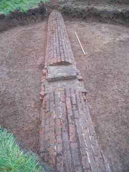
Close to the buildings, considerable disturbance was noted relating to drainage serving the converted Stable Block, which was probably installed at some point after the mid-1990s. On the north side of the house, two walls on a northwest/southeast alignment were identified. The difference in alignment suggests these structures may represent an earlier phase, predating the present buildings at Croome. Additionally, wall foundations of local blue lias stone were interpreted as the remains of the building linking the Red Wing and Stable Block, which was demolished in the late 20th century. Three substantial brick culverts and a smaller stone drain were also recorded forming part of the drainage system installed by 'Capability' Brown in the mid-18th century. One of these sections of culvert appeared to represent a continuation of the substantial brick culvert previously identified and recorded by BAL during installation of the LPG tanks on the North Lawn. Cobbles revealed beneath the existing driveway almost certainly formed part of the original surface of the North Courtyard.
Later, Border Archaeology Ltd (BA) was commissioned by Janine Young Archaeological Consultant National Trust Attingham Park Shrewsbury to carry out a programme of archaeological excavation associated with the installation of two LPG tanks on the North Lawn of Croome Court, a Grade I Listed mid-18th -century National Trust property at High Green Severn Stoke Worcestershire.
The work took place in two stages and involved the excavation of two 6m square trenches. The first of these revealed a substantial culvert crossing the trench diagonally and probably forming part of the drainage system for the landscape parkland begun in 1751 by Lancelot 'Capability' Brown. The culvert was fully recorded and the area backfilled to avoid any potential damage to this feature. An alternative location was identified 2m to the east and a second area was opened, also measuring 6m × 6m. The trench was excavated to natural deposits and, with the exception of a layer of rubble and rubbish on the south side of the trench, no features or deposits of archaeological significance were seen.
