
Defence of Britain Archive
Council for British Archaeology, 2002. (updated 2006) https://doi.org/10.5284/1000327. How to cite using this DOI
Data copyright © Council for British Archaeology unless otherwise stated
This work is licensed under the ADS Terms of Use and Access.

Primary contact
Council for British Archaeology
92 Micklegate
York
YO1 6JX
England
Tel: +44 (0)1904
Fax: 671417
Resource identifiers
- ADS Collection: 324
- DOI:https://doi.org/10.5284/1000327
- How to cite using this DOI
Pillbox - site marked on map supplied by recorder, John Guy.
(Source: Field Visit )
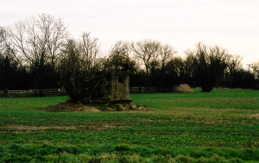
Small hexagonal type 22 pillbox, a variant inasmuch as there are two rifle ports, one each side of the entrance. Concrete-faced. Square, stepped embrasures. Faces W. Stands on small mound with thin concrete base partly exposed. Overgrown on one side. On private land and no access.
(Source: Field Visit 2004/02/10)
Pillbox plotted from German defences map. It is surrounded by a barbed wire perimeter.
(Source: Map 1940/09/03)
Hexagonal pillbox. Faces W. Plotted from air photograph.
(Source: Air Photograph 1946/09/10)
| Type of site | PILLBOX (TYPE FW3/22) |
|---|---|
| Location | SW of Bolingbroke Bridge on the S side of the River Wantsum, Sarre. |
| Area |
Sarre, Kent, England |
| Grid reference |
TR 2517 6480
(Scale: 1:10000
)
|
| Period | WW2 |
| Condition | Fair |
| Materials | Reinforced Concrete |
| Threats |
Type: Plant growth (Long Term) Detail: The pillbox is partly overgrown. |
| Recorder | Guy, John A. (Defence of Britain Project) |
| Defence grouping |
Sarre nodal point - Defences of Sarre Category 'A' nodal point. Cassini ref. R7083. [Source: List of Nodal Points in Eastern Command, 1940 - PRO WO 199/544]. |
| Attached Sheets | (1) - site location map. |
| Photographs |
|
| DOB site reference: | S0013475 |
| Reference |
1946/09/10 106G/UK/1724 (fr.3044) 1940/09/03 Sheet (Blatt) 40 |
| Event |
Construction, In the period 1940 1941 Field Visit, On 2004/02/10 |
