
Defence of Britain Archive
Council for British Archaeology, 2002. (updated 2006) https://doi.org/10.5284/1000327. How to cite using this DOI
Data copyright © Council for British Archaeology unless otherwise stated
This work is licensed under the ADS Terms of Use and Access.

Primary contact
Council for British Archaeology
92 Micklegate
York
YO1 6JX
England
Tel: +44 (0)1904
Fax: 671417
Resource identifiers
- ADS Collection: 324
- DOI:https://doi.org/10.5284/1000327
- How to cite using this DOI
Site in an old quarry with remains of army huts and other concrete bases. It is possible that tunnels to a known Brigade underground battle headquarters lead off from this site. [see also UORN 14957].
(Source: Field Visit 2001/01/23)
The quarry still contains five huts, three Nissens and two Turners, and was clearly once the site of an army camp or other establishment.
(Source: Field Visit 2004/02/10)
Report from web site of Subterranea Britannica - 1998.
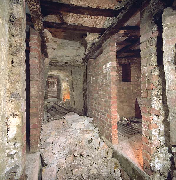
In late 1940 a network of underground battle headquarters was established by South East Army Command with tunnels excavated at Tunbridge Wells, Canterbury and Reigate. There was also an underground brigade HQ located in a disused quarry at Sarre on the Isle of Thanet in Kent which was subordinate to the Battle HQ at Canterbury. The area was fortified by Canadians who would help form the defence force if needed to reinforce South East Command forces on invasion.The brigade headquarters consisted of three parallel stairways cut into the chalk quarry face in the north side of the quarry, these descended fifty feet into a small complex of tunnels and rooms. Two of the stairways lead directly into the main spine corridor. This is brick lined for most of its length but the western end is unlined with rotting timber pit props; this section appears to be unfinished. There are two brick lined rooms on either side of the corridor with a third room at the eastern end. Two of these rooms still retain lettering on the brick work, one is labeled 'Sigs' indicating that it was a signals room and the other is labeled 'Clerks Int Sec'. Four of the rooms have small rectangular alcoves set into the walls. One of the rooms has three metal pipes protruding from the ceiling, these carried cables to the surface. There is a fourth cable duct in the corridor. The third stairway leads to a 35 metre long tunnel supported with inverted steel hoops and lined with corrugated steel sheets, similar to the many coast battery deep shelters found along the Kent Coast. The floor is littered with rubble from minor roof falls but the brick lined sections of the tunnels are generally in good condition although timber door frames are rotting or have gone altogether. After the war, the three entrances were bricked up but when visited in 1998 access to the eastern stairway was possible as the corrugated steel lining that protruded some distance out from the quarry face had largely rotted away. The other two stairways had been backfilled with rubble. Since that date the three entrance tunnels have been bulldozed and all evidence of their position has now been lost.
Five Nissen huts and several other hut bases can still be seen on the quarry floor but these may be the domestic camp for a heavy anti-aircraft gun battery located nearby.
(Source: Report 1998)
| Type of site | ARMY BATTLE HEADQUARTERS |
|---|---|
| Location | On the N side of a disused quarry off the A28 road on the NE side of Sarre. |
| Area |
Sarre, Kent, England |
| Grid reference |
TR 2585 6514
(Scale: 1:10000
)
|
| Period | WW2 |
| Condition | Good |
| Materials | Unknown |
| Recorder | Guy, John A. (Defence of Britain Project) |
| Defence grouping |
Sarre nodal point - Defences of Sarre Category 'A' nodal point. Cassini ref. R7083. [Source: List of Nodal Points in Eastern Command, 1940 - PRO WO 199/544]. |
| Attached Sheets | (1) - site location map. |
| Photographs |


|
| DOB site reference: | S0013476 |
| Event |
Construction, In the period 1940 1941 Field Visit, On 2001/01/23 Field Visit, On 2004/02/10 Field Visit, During 1998/01 |
