
Defence of Britain Archive
Council for British Archaeology, 2002. (updated 2006) https://doi.org/10.5284/1000327. How to cite using this DOI
Data copyright © Council for British Archaeology unless otherwise stated
This work is licensed under the ADS Terms of Use and Access.

Primary contact
Council for British Archaeology
92 Micklegate
York
YO1 6JX
England
Tel: +44 (0)1904
Fax: 671417
Resource identifiers
- ADS Collection: 324
- DOI:https://doi.org/10.5284/1000327
- How to cite using this DOI
Concrete pillbox.
(Source: Field Visit 1997/09)
Concrete type 24 pillbox facing E: narrow wall version with brick skin.
(Source: SMR )
Pillbox plotted from air photograph. [It appears to have a pitched roof, perhaps remaining camouflage].
(Source: Air Photograph 1950/06/29)
Pillbox plotted from OS 1:2500 sheet.
(Source: Map 1974)
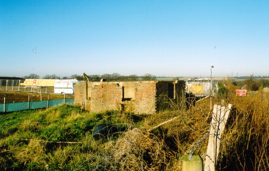
Brick-shuttered type 24 pillbox, with no brickwork above embrasures. Faces NE. Interior access possible. This pillbox is to be destroyed by road works.
(Source: Field Visit 2003/12/18)
| Type of site | PILLBOX (TYPE FW3/24) |
|---|---|
| Location | On NW corner of junction between Ratcliffe Highway (A228), Dux Court Road, and Bell's Lane.
|
| Area |
Hoo St. Werburgh, Medway Council, England |
| Grid reference |
TQ 77655 73352
(Scale: 1:2500
, 197)
|
| Period | WW2 |
| Condition | Removed |
| Materials | Clay Brick, Reinforced Concrete |
| Threats |
Type: Road construction (Immediate) Detail: The pillbox is to be destroyed by work to build a roundabout at this junction. |
| Recorder | Fray, A.E. |
| Defence grouping |
GHQ Line (North West Kent) - GHQ Line running from Leigh to River Thames via Medway valley. |
| Photographs |
|
| DOB site reference: | S0002706 |
| Associated Identifier | Kent SMR (ref: KE15171: TQ 77 SE 99) |
| Original Reference | 8053 |
| Reference |
1977 A Handbook of Kent's Defences 1950/06/29 541/591 (fr.4026) |
| Event |
Field Visit, On 1997/09 Construction, In the period 1940 1941 Removal, During 2004 Field Visit, On 2003/12/18 |
