
Defence of Britain Archive
Council for British Archaeology, 2002. (updated 2006) https://doi.org/10.5284/1000327. How to cite using this DOI
Data copyright © Council for British Archaeology unless otherwise stated
This work is licensed under the ADS Terms of Use and Access.

Primary contact
Council for British Archaeology
92 Micklegate
York
YO1 6JX
England
Tel: +44 (0)1904
Fax: 671417
Resource identifiers
- ADS Collection: 324
- DOI:https://doi.org/10.5284/1000327
- How to cite using this DOI
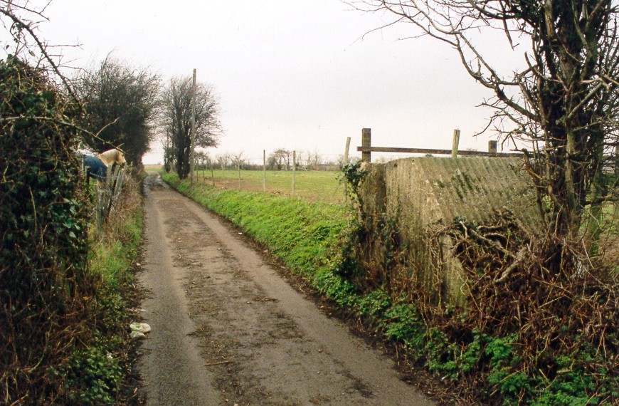
2 anti-tank blocks.
(Source: Field Visit 1997/09)
Roadblock plotted from German map.
(Source: Map 1940/11/20)
Blocks each side of track plotted from air photograph show site of roadblock.
(Source: Air Photograph 1946/05/01)
Two anti-tank blocks constructed with corrugated-iron shuttering, one each side of trackway, with sloping faces on S side and slot to take horizontal rails.
(Source: Field Visit 2004/03/04)
| Type of site | ANTI TANK HORIZONTAL RAIL |
|---|---|
| Location | Either side of trackway to Tile Barn Farm, one hundred yards N of Stoke Road, E of Hoo. |
| Area |
Hoo St. Werburgh, Medway Council, England |
| Grid reference |
TQ 78911 72837
|
| Period | WW2 |
| Condition | Good |
| Materials | Concrete |
| Recorder | Fray, A.E. |
| Defence grouping |
GHQ Line (North West Kent) - GHQ Line running from Leigh to River Thames via Medway valley. |
| Photographs |
|
| DOB site reference: | S0002707 |
| Original Reference | 8054 |
| Reference |
1940/11/20 Sheet (Blatt) 116 1946/05/01 106G/UK/1444 (fr.3042) |
| Event |
Field Visit, During 1997/09 Construction, In the period 1940/11 Field Visit, On 2004/03/04 |
