
Defence of Britain Archive
Council for British Archaeology, 2002. (updated 2006) https://doi.org/10.5284/1000327. How to cite using this DOI
Data copyright © Council for British Archaeology unless otherwise stated
This work is licensed under the ADS Terms of Use and Access.

Primary contact
Council for British Archaeology
92 Micklegate
York
YO1 6JX
England
Tel: +44 (0)1904
Fax: 671417
Resource identifiers
- ADS Collection: 324
- DOI:https://doi.org/10.5284/1000327
- How to cite using this DOI
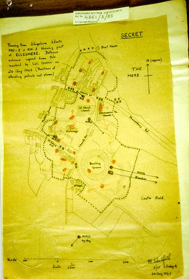
Ellesmere was given all-round defence as shown by plan attached. Plan from Shropshire records 4861/3/33
Fieldwork has failed to show any trace of the features marked on the map. The map has been DIGITISED on to the record.
Field work undertaken on 1 December 1998
(Source: Document 1943/10/03)
| Type of site | DEFENDED LOCALITY |
|---|---|
| Location | Ellesmere, Shropshire. Centred on area bounded by 12c castle mound, church, vicarage and The Mere. |
| Area |
Ellesmere, Shropshire, England |
| Grid reference |
SJ 403 348
(Scale: 1:50000
, 1994)
|
| Period | WW2 |
| Condition | Unknown |
| Materials | Unknown |
| Recorder | Lowry, Bernard (Defence of Britain Project) |
| Attached Sheets | (2) - additional notes and map |
| Photographs |
(1) - photographed map of defence plan (DIGITISED) |
| DOB site reference: | S0005965 |
| Reference |
1942/03/19 Shropshire Archives 4861/3/33 |
| Event |
Construction, In the period 1940 1942 Field Visit, On 1998/12/01 |
