
Defence of Britain Archive
Council for British Archaeology, 2002. (updated 2006) https://doi.org/10.5284/1000327. How to cite using this DOI
Data copyright © Council for British Archaeology unless otherwise stated
This work is licensed under the ADS Terms of Use and Access.

Primary contact
Council for British Archaeology
92 Micklegate
York
YO1 6JX
England
Tel: +44 (0)1904
Fax: 671417
Resource identifiers
- ADS Collection: 324
- DOI:https://doi.org/10.5284/1000327
- How to cite using this DOI
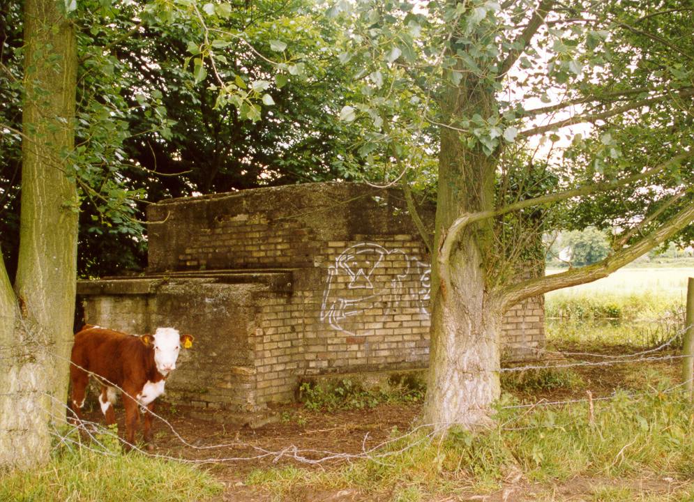
Type 27 pillbox. Octagonal pillbox with creep through entrance and small embrasures in each wall. In the middle is an LAA chamber with mounting intact.
(Source: Field Visit 1999/06/03)
Type 27 pillbox. Octagonal pillbox with creep through entrance and small embrasures in each wall. In the middle is an LAA chamber with mounting intact.
(Source: Field Visit 1999/06/03)
Large pillbox, of a type common in this area. Octagonal, with central chamber with mounting for anti-aircraft gun. Pit is 6-sided, each side with a small hole leading downwards into the main part of the pillbox. Small embrasures. 'Creep-through' entrance on W side with raised lip at entrance to keep out floodwater. The inside is now full of broken bottles, beer cans, etc. The yellow brick cladding is mostly gone. There are the remains of two vertical metal bars, cut off flush with the roof, which probably held up camouflage netting.
(Source: Field Visit 1999/06/03)
Type 27 pillbox. Most of the brick shuttering is in place. Faces river - NE. Some graffiti on exterior walls. Access possible owing to collapsed barbed wire.
(Source: Field Visit 2002/06/12)
Octagonal structure plotted from OS 1:2500 sheet.
(Source: Map 1964)
Pillbox with 1ft 3ins walls. Serial no. S. 106. Cassini ref. 317606.
(Source: Document 1940)
| Type of site | PILLBOX (TYPE FW3/27) |
|---|---|
| Location | In Sudbury Meadows, on the SW bank of the River Stour, some 350m SE of Brundon Mill. |
| Area |
Sudbury, Suffolk, England |
| Grid reference |
TL 86739 42143
(Scale: 1:2500
, 1964)
|
| Period | WW2 |
| Condition | Good |
| Materials | Clay Brick, Reinforced Concrete, Steel |
| Threats |
Type: Deterioration (Medium Term) Detail: Remaining brick shuttering threatened by further weathering. Type: River bank erosion (Medium Term) Detail: Base of pillbox being undermined by river bank erosion. Type: Vandalism (Immediate) Detail: Some graffiti spray-painted onto exterior walls. |
| Recorder | Silverlock, R.A. |
| Defence grouping |
Eastern Command: Corps and Command Stop Lines - One of three Eastern Command Corps stop lines, this one running from the River Colne in Essex via Wakes Colne and Bures, along the River Stour to Sudbury and Long Melford, and thence to Bury St. Edmunds and the River Lark at Mildenhall. Its final stretch (known now as the Command Line) was via Littleport along the line of the River Great Ouse to King's Lynn. Sudbury nodal point - Defences of Sudbury category 'A' nodal point in No.4 region. Cassini ref. M3259. [Source: List of Nodal Points in Eastern Command, 1940 - PRO WO 199/544]. |
| Attached Sheets | Additional SRF by Sue Burden |
| Photographs |
(2) - external views |
| Adjacent sites | Sites (RS.8/18) 350m to NW and (RS.8/20) 200m to SSE. |
| DOB site reference: | S0006432 |
| Reference |
1985 Pillboxes: A Study of UK Defences 1941/11/14 Suffolk Sub Area Defence Scheme |
| Event |
Construction, In the period 1940 1941 Field Visit, On 1996/06/21 Field Visit, On 2002/06/12 Field Visit, On 1999/06/03 |
