
Defence of Britain Archive
Council for British Archaeology, 2002. (updated 2006) https://doi.org/10.5284/1000327. How to cite using this DOI
Data copyright © Council for British Archaeology unless otherwise stated
This work is licensed under the ADS Terms of Use and Access.

Primary contact
Council for British Archaeology
92 Micklegate
York
YO1 6JX
England
Tel: +44 (0)1904
Fax: 671417
Resource identifiers
- ADS Collection: 324
- DOI:https://doi.org/10.5284/1000327
- How to cite using this DOI
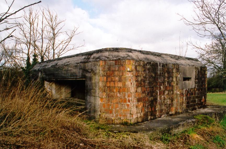
Type 28a anti-tank gun emplacement.
(Source: Field Visit 1999/05)
Structure plotted from OS 1:2500 sheet.
(Source: Map 1989)
Square structure plotted from air photograph.
(Source: Air Photograph 1959/07/14)
Anti-tank gun emplacement (type 28a, with separate infantry chamber). Part brick faced, part concrete-faced. Chamfered roof edge. Stands on thick concrete base. Three embrasures for light machine gun and rifle fire in addition to main 2pdr anti-tank gun embrasure. Interior lined with breeze blocks. Brick work uses an unusual end-on hollow brick. Main embrasure faces SW commanding road. No proper access as in private field.
(Source: Field Visit 2003/02/04)
Anti-tank gun emplacement. Ref. 60.
(Source: Document 1940/12)
| Type of site | PILLBOX (TYPE FW3/28A) |
|---|---|
| Location | In field on E side of A350 High Street, just N of its junction with St. George's Road, Semington. |
| Area |
Semington, Wiltshire, England |
| Grid reference |
ST 89745 60400
|
| Period | WW2 |
| Condition | Good |
| Materials | Breeze Block, Clay Brick, Concrete, Reinforced Concrete |
| Recorder | Dennett, David |
| Defence grouping |
GHQ Line: Blue - Section of GHQ Stop Line running from near Melksham to Reading. Semington centre of resistance - The defences of Semington on the GHQ Blue Line. After 1940 the defences were developed as a Centre of Resistance (Nodal Point) manned by the 4th Bn. Wiltshire Home Guard. (South Wiltshire Sub Area, 1942 - PRO WO 166/6785). |
| Photographs |
(3) - external views |
| DOB site reference: | S0008113 |
| Reference |
1999 Ironside's Line 1940/12 [copy of map of 4th Bn. Wiltshire Home Guard showing defence positions on the Kennet & Avon Canal] 1959/07/14 58/3021 (fr.44) |
| Event |
Construction, In the period 1940 1941 Field Visit, During 1999/05 Field Visit, On 2003/02/04 |
