England's Historic Seascapes: Liverpool Bay Pilot Area

Wessex Archaeology, 2006. https://doi.org/10.5284/1000010. How to cite using this DOI

Digital Object Identifiers

Digital Object Identifiers (DOIs) are persistent identifiers which can be used to consistently and accurately reference digital objects and/or content. The DOIs provide a way for the ADS resources to be cited in a similar fashion to traditional scholarly materials. More information on DOIs at the ADS can be found on our help page.

Citing this DOI

The updated Crossref DOI Display guidelines recommend that DOIs should be displayed in the following format:

https://doi.org/10.5284/1000010
Sample Citation for this DOI

Wessex Archaeology (2006) England's Historic Seascapes: Liverpool Bay Pilot Area [data-set]. York: Archaeology Data Service [distributor] https://doi.org/10.5284/1000010

Data copyright © Historic England unless otherwise stated

This work is licensed under the ADS Terms of Use and Access.
Creative Commons License


Aggregates Levy Sustainability Fund logo
Historic England logo

Primary contact

Wessex Archaeology
Portway House
Old Sarum Park
Salisbury
SP4 6EB
UK
Tel: 01722 326867
Fax: 01722 337562

Send e-mail enquiry

Resource identifiers

Digital Object Identifiers

Digital Object Identifiers (DOIs) are persistent identifiers which can be used to consistently and accurately reference digital objects and/or content. The DOIs provide a way for the ADS resources to be cited in a similar fashion to traditional scholarly materials. More information on DOIs at the ADS can be found on our help page.

Citing this DOI

The updated Crossref DOI Display guidelines recommend that DOIs should be displayed in the following format:

https://doi.org/10.5284/1000010
Sample Citation for this DOI

Wessex Archaeology (2006) England's Historic Seascapes: Liverpool Bay Pilot Area [data-set]. York: Archaeology Data Service [distributor] https://doi.org/10.5284/1000010

Interactive Map

Map Viewer

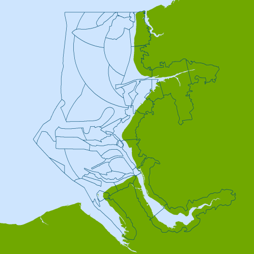
The map below shows the Liverpool Bay study area divided into Character Areas. Use the buttons below to view the map divided into Character Types. Click on an area of the map to view more information on the geographic character area.
character map
Character Areas

Character Types

          Key:

legendCoastal environment
legendCoastal industry
legendCoastal military
legendCoastal recreation
legendCoastal settlement
legendFisheries
legendIntrusive industry
legendMaritime safety
legendNavigation activity
legendNavigation feature
legendNavigation hazard
legendNon-intrusive industry
legendPorts and harbours
legendPrehistoric land surface
legendUK coast
 
Gut Channel Upper Ribble Formby Light Hamilton Gas Field Liverpool Bay Dredging Area Little Burbo Zebra Flats Rossall Patches Rossall Point Shell Flat Lune Deep Mockbeggar Wharf Hilbre Swash Hilbre Swash Crusader Bank South Gut Great Bank Dee Estuary Upper Mersey Jordans Spit Off Southport Taylors Bank Formby Bank Off Heysham Off Blackpool North Shore Rossall Oyster Grounds Mad Wharf Sands River Ribble Great Burbo Flats North Bank East Hoyle Spit East Hoyle Bank Lime Wharf Morecambe Light Liverpool Bay Burbo Bank Blackpool Marshside Sands Formby Spit Off Formby Crosby Channel Bootle Bay River Mersey and Docks
 

Copyright information

Derived from 1:250,000 scale BGS Digital Data under licence No. 2004/167.

British Geological Survey © NERC This product has been derived in part from material obtained from the UK Hydrographic Office with the permission of the Controller of Her Majesty's Stationery Office and UK Hydrographic Office www.ukho.gov.uk

© British Crown and SeaZone Solutions Ltd, 2004. All rights reserved. Data Licence No. 122004.007. NOT TO BE USED FOR NAVIGATION.

Digital Map Data © (2004) XYZ Digital Map Company.


ADS logo
Data Org logo
University of York logo