
England's Historic Seascapes: Scarborough to Hartlepool
Cornwall Council, 2007. https://doi.org/10.5284/1000201. How to cite using this DOI
Data copyright © Historic England unless otherwise stated
This work is licensed under the ADS Terms of Use and Access.


Primary contact
Charlie
Johns
Cornwall Council
Kennall Building, Old County Hall
Station Road
Truro
TR1 3AY
UK
Tel: 01872 322056
Resource identifiers
- ADS Collection: 744
- ALSF Project Number: 4731
- DOI:https://doi.org/10.5284/1000201
- How to cite using this DOI
Introduction | Seascapes Character Types
Introduction
The content of the web-pages below are the result of an English Heritage initiative to preserve and disseminate the results of the full scope of work undertaken under the Seascapes ALSF grant. Data copyright for all material presented on these pages is retained by the depositor and English Heritage.
These HTML pages present the results of a pilot project commissioned by English Heritage and undertaken by Cornwall County Council's Historic Environment Service (Projects) in 2006-7, to apply Historic Seascape Characterisation (HSC) to the coastal, inter-tidal and marine zones of North Yorkshire, Cleveland and Teesside, from Scarborough to Hartlepool, as part of England's Historic Seascapes Programme. Sponsored by the Aggregates Levy Sustainability Fund (ALSF), it is one of four pilot projects of varying coastal and marine contexts designed to test the methodology developed by Wessex Archaeology in an initial pilot in Liverpool Bay.
The whole study area is an historic seascape altered, transformed and affected by human activities. Seeking an archaeological understanding of the historical and cultural development of the present marine, inter-tidal and coastal areas, this pilot project maps historic character and sea-use within a GIS, using historic charts, maps and associated documentary sources alongside modern marine data.
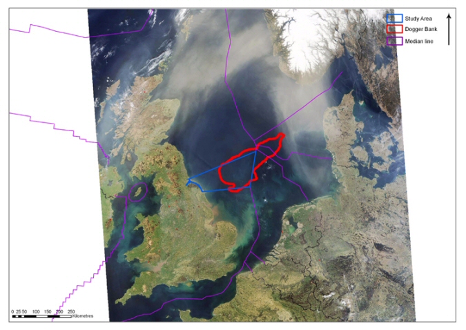
Scarborough to Hartlepool Study Area. © Cornwall Historic Environment Services and Wikipedia page http://upload.wikimedia.org/wikipedia/commons/5/59/Doggerbank.jpg
Source-led and guided by current terrestrial multi-mode HLC methodology it defines areas that share similar and repeating historic character as Historic Seascape Character 'Types', allowing historic trends and processes to inform and frame the broader sustainable management of change, through marine spatial planning, outreach and research projects.
To reflect the multi-dimensional or multi-layered nature of the marine environment (ie. the seabed, seafloor, water column and surface) a fine grid of cells, with tiered attributes, is used in this HSC to record the present and dominant historic character for each marine layer. Inter-tidal and coastal areas, whose sources are those of the established terrestrial HLC, are captured as polygons. From this complex database a single, conflated HSC layer is derived. To assist the wide variety of users of HSC, texts have been prepared for each HSC Type, describing different aspects of the historic character including identifying distinguishing attributes and principal locations; their constituent components, features and variability; the values and perceptions that people have of these areas; the research, amenity and education potential they offer; their present condition and forces for change affecting them, which in turn inform statements on their rarity and vulnerability allowing broad recommendations to be suggested for their management.
Copyright Information
This product has been derived in part from material obtained from the OS maps with the permission of the Controller of Her Majesty's Stationery Office and Ordnance Survey www.ordnancesurvey.co.uk
This product has been derived in part from material obtained from the UK Hydrographic Office with the permission of the Controller of Her Majesty's Stationery Office and UK Hydrographic Office www.ukho.gov.uk.
© British Crown and SeaZone Solutions Ltd. All rights reserved. Data Licence No. 062006.003. NOT TO BE USED FOR NAVIGATION.
